
Carrickfergus Borough Council facts for kids
Quick facts for kids Carrickfergus Borough (historical)
|
|
|---|---|
 |
|
| Area | 82 km2 (32 sq mi) |
| Country | Northern Ireland |
| Sovereign state | United Kingdom |
| EU Parliament | Northern Ireland |
| Councillors |
|

The Carrickfergus Borough Council was a local government group in County Antrim, Northern Ireland. Think of it like a team of people who helped manage the town of Carrickfergus and the areas around it. This council was based at Carrickfergus Town Hall.
The area it looked after stretched from Greenisland in the southwest to Whitehead in the east. It was about 82 square kilometers (32 square miles) and had a population of just over 39,000 people.
In May 2015, the Carrickfergus Borough Council joined up with two other councils, Ballymena Borough Council and Larne Borough Council. Together, they formed a new, bigger council called the Mid and East Antrim Borough Council. This change happened because of a plan to reorganize local government in Northern Ireland.
The Carrickfergus area, along with nearby Larne and small parts of Newtownabbey and Moyle, formed the East Antrim area. This area is important for choosing people to represent them in the Westminster Parliament (the main government in the UK) and the Northern Ireland Assembly (the local government in Northern Ireland).
Contents
Who Were the Mayors of Carrickfergus?
A mayor is like the leader of a town or city council. They are chosen to represent the area and lead the council's meetings. Carrickfergus has had mayors for a very long time!
Mayors Since 1949
Here is a list of the mayors of the Carrickfergus Borough Council from 1949 until it merged in 2015.
During the time of King George VI
- 1949–1951 Thomas John Patterson
- 1951–1952 William McCullough
During the time of Queen Elizabeth II
- 1952–1973 Thomas John Patterson
- 1973–1978 Hugh McLean
- 1978–1979 Samuel Murphy
- 1979–1981 Samuel Simms
- 1981–1983 Ken McFaul
- 1983–1984 Samuel Murphy
- 1984–1986 Charles Johnston
- 1986–1990 Jim Brown
- 1990–1991 Charles Johnston
- 1991–1992 W. A. Haggan
- 1992–1993 Stewart Dickson
- 1993–1994 Sean Neeson
- 1994–1995 J. Crowe
- 1995–1996 W. S. Hamilton
- 1996–1997 S. Y. McCamley
- 1997–1998 David Hilditch
- 1998–1999 B. J. Crampsey (She was the first woman to be mayor!)
- 1999–2000 T. Creighton
- 2000–2001 Jim Brown
- 2001–2002 Billy Ashe
- 2002–2003 Eric Ferguson
- 2003–2004 May Beattie (She was the second woman mayor!)
- 2004–2008 David Hilditch
- 2008–2010 Patricia McKinney (She was the third woman mayor!)
- 2010–2012 Jim McClurg
- 2012–2014 Billy Ashe
- 2014–2015 Charles Johnston (He was the very last mayor of the Carrickfergus Borough Council before it merged.)
- Source: Carrickfergus Borough Council
Honorary Freemen of Carrickfergus
Being an "Honorary Freeman" is a special award given to people or groups who have done great things for the town. It's like giving them the "keys to the city" as a sign of respect and thanks.
Here are some of the people and groups who received this special honor from the Carrickfergus Borough Council since 1949:
- Alderman William McCullough JP (October 6, 1952)
- Alderman Walter McKeown MBE (October 15, 1956)
- Alderman Thomas John Patterson OBE JP (March 7, 1960)
- Councillor Hugh McLean OBE (January 16, 1978)
- Samuel Murphy MBE JP (November 4, 1986)
- Samuel Simms (November 4, 1986)
- Joan Catherine Tomlin (November 4, 1986)
- The Ulster Defence Regiment (October 1, 1988)
- The Royal Irish Regiment (April 17, 1993)
- Raymond Boyd ACIS (April 12, 2001)
- William Hume (April 12, 2001)
- Charles Johnston (April 12, 2001)
- Terence Murtagh JP (April 12, 2001)
- The Northern Ireland Fire & Rescue Service (August 4, 2006)
- Source: [PDF] CBC Compass 18 Spring/Summer 09 v4 Carrickfergus Borough
How Many People Lived There?
According to a count of the population in 2011 (called the Northern Ireland census), there were 39,114 people living in the area that the Carrickfergus Borough Council looked after.
Images for kids
-
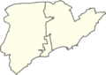
A map showing the areas of the Carrickfergus borough from 1993 to 2014.
