Carroll County, Kentucky facts for kids
Quick facts for kids
Carroll County
|
|
|---|---|

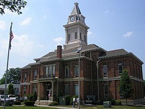
Carroll County Courthouse in Carrollton
|
|

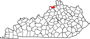
Location within the U.S. state of Kentucky
|
|
 Kentucky's location within the U.S. |
|
| Country | |
| State | |
| Founded | 1838 |
| Named for | Charles Carroll of Carrollton |
| Seat | Carrollton |
| Largest city | Carrollton |
| Area | |
| • Total | 137 sq mi (350 km2) |
| • Land | 129 sq mi (330 km2) |
| • Water | 8.7 sq mi (23 km2) 6.4%% |
| Population
(2020)
|
|
| • Total | 10,810 |
| • Estimate
(2023)
|
10,987 |
| • Density | 78.9/sq mi (30.47/km2) |
| Time zone | UTC−5 (Eastern) |
| • Summer (DST) | UTC−4 (EDT) |
| Congressional district | 4th |
Carroll County is a special area called a county in the northern part of Kentucky. Its main town, or county seat, is Carrollton. The county was started in 1838. It was named after Charles Carroll of Carrollton. He was the very last person alive who signed the Declaration of Independence. Carroll County is unique because the Kentucky River flows into the Ohio River right here.
Contents
Exploring Carroll County: Geography
Carroll County covers a total area of about 137 square miles. Most of this area, about 129 square miles, is land. The rest, about 8.7 square miles, is water. This makes it the third smallest county in Kentucky by size.
Nearby Counties
Carroll County shares its borders with several other counties:
- Jefferson County, Indiana (to the north)
- Switzerland County, Indiana (to the northwest)
- Gallatin County (to the east)
- Owen County (to the southeast)
- Henry County (to the south)
- Trimble County (to the west)
People of Carroll County: Demographics
| Historical population | |||
|---|---|---|---|
| Census | Pop. | %± | |
| 1840 | 3,966 | — | |
| 1850 | 5,526 | 39.3% | |
| 1860 | 6,578 | 19.0% | |
| 1870 | 6,189 | −5.9% | |
| 1880 | 8,953 | 44.7% | |
| 1890 | 9,266 | 3.5% | |
| 1900 | 9,825 | 6.0% | |
| 1910 | 8,110 | −17.5% | |
| 1920 | 8,346 | 2.9% | |
| 1930 | 8,155 | −2.3% | |
| 1940 | 8,657 | 6.2% | |
| 1950 | 8,517 | −1.6% | |
| 1960 | 7,978 | −6.3% | |
| 1970 | 8,523 | 6.8% | |
| 1980 | 9,270 | 8.8% | |
| 1990 | 9,292 | 0.2% | |
| 2000 | 10,155 | 9.3% | |
| 2010 | 10,811 | 6.5% | |
| 2020 | 10,810 | 0.0% | |
| 2023 (est.) | 10,987 | 1.6% | |
| U.S. Decennial Census 1790-1960 1900-1990 1990-2000 2010-2020 |
|||
In 2000, about 10,155 people lived in Carroll County. There were nearly 4,000 households. Many families lived together. The population density was about 78 people for every square mile.
About 95% of the people were White. A smaller number were Black or African American, Native American, or Asian. Some people identified with two or more races. About 3% of the population was of Hispanic or Latino background.
Many households had children under 18 living with them. Over half of the households were married couples. Some households were led by a female without a husband. About a quarter of all households were individuals living alone. This included people aged 65 or older.
The average household had about 2.5 people. The average family had nearly 3 people. The median age in the county was 36 years old. This means half the people were younger than 36 and half were older.
Towns and Villages: Communities
Carroll County is home to several towns and one unincorporated community.
Cities
- Carrollton (This is the county seat, where the main government offices are)
- Ghent
- Prestonville
- Sanders
- Worthville
Unincorporated Community
See also
 In Spanish: Condado de Carroll (Kentucky) para niños

