Caruthersville, Missouri facts for kids
Quick facts for kids
Caruthersville, Missouri
|
|
|---|---|

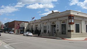
Ward Avenue downtown
|
|

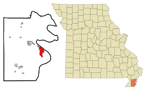
Location within Pemiscot County and Missouri
|
|
| Country | United States |
| State | Missouri |
| County | Pemiscot |
| Incorporated | May 18, 1874 |
| Named for | Samuel Caruthers (U.S. Congressman) |
| Area | |
| • Total | 5.24 sq mi (13.56 km2) |
| • Land | 5.16 sq mi (13.36 km2) |
| • Water | 0.08 sq mi (0.20 km2) |
| Elevation | 269 ft (82 m) |
| Population
(2020)
|
|
| • Total | 5,562 |
| • Density | 1,078.32/sq mi (416.37/km2) |
| Time zone | UTC-6 (Central (CST)) |
| • Summer (DST) | UTC-5 (CDT) |
| ZIP code |
63830
|
| Area code(s) | 573 |
| FIPS code | 29-11692 |
| GNIS feature ID | 2393761 |
Caruthersville is a city located in the southeastern part of Missouri, along the Mississippi River. It is the main town and county seat of Pemiscot County. This area is often called the "Bootheel" because of its shape on the map. In 2020, about 5,562 people lived in Caruthersville.
Contents
History of Caruthersville
Caruthersville is in a unique part of Missouri known as the Bootheel. This area is very flat and close to the Mississippi River. The name "Pemiscot" comes from a Native American word meaning "liquid mud." This is because the river often floods the land, leaving behind very rich soil for farming.
Early Settlements and Native Americans
For thousands of years, Native American tribes lived in the Caruthersville area. The Mississippian culture built large mounds of earth throughout the Mississippi Valley. One of these mounds, called Murphy Mound, is still in Pemiscot County. It stands about 270 feet tall, much higher than the flat land around it.
Founding the City
The town of Caruthersville was officially planned and mapped out in 1857. This was done by John Hardeman Walker and G. W. Bushey. The town was named after Samuel Caruthers, who was a US Congressman for the area.
The City of Caruthersville became an official city on May 18, 1874. Early records, like the Sanborn Maps, show how the town grew. These maps recorded details about buildings, like who owned them and what they were made of.
Protecting the Land from Floods
Because the area is so flat and near the river, floods were a big problem. In 1893, Missouri's government created the Saint Francis Levee District. This group was in charge of building and taking care of levees. Levees are like big walls built to hold back river water and protect the land.
Building the Caruthersville Bridge
In 1969, construction started on a bridge over the Mississippi River at Caruthersville. This bridge was finished in 1976. It is very important because it's the only bridge that crosses the Mississippi River between Cairo, Illinois and Memphis, Tennessee. The bridge carries Interstate 155 and U.S. Route 412.
Recent Events
On April 2, 2006, a series of tornadoes hit the Midwestern United States. About 60% of Caruthersville was badly damaged or destroyed. Many homes, churches, and schools were affected. For example, Caruthersville High School and Middle School were damaged. The storm caused a lot of damage and many people had to leave their homes. Electricity and water services were also stopped for a time. Luckily, there were no deaths reported within the city limits.
Geography and Climate
Caruthersville is located at 36°11′5″N 89°39′41″W / 36.18472°N 89.66139°W. The city covers about 5.24 square miles, with most of it being land and a small part being water. It sits on the western bank of the Mississippi River in the Bootheel region. The area is also part of the New Madrid Seismic Zone, which means it can experience earthquakes.
Weather in Caruthersville
Caruthersville has a humid subtropical climate. This means it has hot and humid summers. The winters are generally mild to cool. You can see more details about the weather in the table below.
| Climate data for Caruthersville, MO | |||||||||||||
|---|---|---|---|---|---|---|---|---|---|---|---|---|---|
| Month | Jan | Feb | Mar | Apr | May | Jun | Jul | Aug | Sep | Oct | Nov | Dec | Year |
| Record high °F (°C) | 76 (24) |
82 (28) |
88 (31) |
93 (34) |
102 (39) |
109 (43) |
109 (43) |
111 (44) |
108 (42) |
98 (37) |
87 (31) |
79 (26) |
111 (44) |
| Mean daily maximum °F (°C) | 43 (6) |
49 (9) |
59 (15) |
69 (21) |
78 (26) |
87 (31) |
91 (33) |
89 (32) |
82 (28) |
72 (22) |
59 (15) |
48 (9) |
69 (21) |
| Mean daily minimum °F (°C) | 27 (−3) |
32 (0) |
40 (4) |
49 (9) |
60 (16) |
67 (19) |
71 (22) |
69 (21) |
62 (17) |
50 (10) |
40 (4) |
32 (0) |
50 (10) |
| Record low °F (°C) | −15 (−26) |
−8 (−22) |
5 (−15) |
21 (−6) |
34 (1) |
45 (7) |
54 (12) |
48 (9) |
37 (3) |
27 (−3) |
5 (−15) |
−9 (−23) |
−15 (−26) |
| Average precipitation inches (mm) | 3.46 (88) |
3.76 (96) |
4.82 (122) |
5.00 (127) |
5.02 (128) |
4.60 (117) |
3.93 (100) |
3.01 (76) |
3.06 (78) |
3.56 (90) |
4.85 (123) |
4.78 (121) |
49.85 (1,266) |
| Average snowfall inches (cm) | 3.70 (9.4) |
2.90 (7.4) |
0.90 (2.3) |
0 (0) |
0 (0) |
0 (0) |
0 (0) |
0 (0) |
0 (0) |
0 (0) |
0.20 (0.51) |
1.50 (3.8) |
9.20 (23.4) |
| Source: http://www.intellicast.com/Local/History.aspx?location=USMO0151 | |||||||||||||
Population and People
The population of Caruthersville has changed over the years. Here's how it has grown and shrunk:
| Historical population | |||
|---|---|---|---|
| Census | Pop. | %± | |
| 1890 | 230 | — | |
| 1900 | 2,315 | 906.5% | |
| 1910 | 3,655 | 57.9% | |
| 1920 | 4,750 | 30.0% | |
| 1930 | 4,781 | 0.7% | |
| 1940 | 6,612 | 38.3% | |
| 1950 | 8,614 | 30.3% | |
| 1960 | 8,643 | 0.3% | |
| 1970 | 7,350 | −15.0% | |
| 1980 | 7,958 | 8.3% | |
| 1990 | 7,389 | −7.2% | |
| 2000 | 6,760 | −8.5% | |
| 2010 | 6,168 | −8.8% | |
| 2020 | 5,562 | −9.8% | |
| U.S. Decennial Census | |||
2020 Census Information
| Race | Num. | Perc. |
|---|---|---|
| White | 3,169 | 56.98% |
| Black or African American | 1,922 | 34.56% |
| Native American | 7 | 0.13% |
| Asian | 17 | 0.31% |
| Pacific Islander | 1 | 0.02% |
| Other/Mixed | 297 | 5.34% |
| Hispanic or Latino | 149 | 2.68% |
In 2020, there were 5,562 people living in Caruthersville. There were 2,360 households and 1,352 families.
2010 Census Information
In 2010, the city had 6,168 people. There were 2,454 households, and 1,567 of those were families. The city had about 1,195 people per square mile.
Most people in Caruthersville were White (63.89%) or Black/African American (33.09%). About 2.35% of the population was Hispanic or Latino.
The average age of people in Caruthersville was 34.2 years old. About 29.5% of residents were under 18. About 14.1% were 65 years old or older.
Education in Caruthersville
The Caruthersville 18 School District runs the schools in the city. There is one elementary school, one middle school, and Caruthersville High School. The town also has a public library called the Caruthersville Public Library.
Economy and Jobs
The economy in Caruthersville relies heavily on the Mississippi River and farming. About 60% of the local economy comes from agriculture. Farmers in the area grow crops like rice, soybeans, and cotton. These crops are often sent by river barges to other places.
A riverboat casino in Caruthersville has also helped the local economy. It brings in tourists and provides new jobs.
Cool Architecture
Caruthersville has a special building called the Caruthersville Water Tower. It was built between 1902 and 1903. This water tower looks like a lighthouse! It's one of only three in the entire country that looks this way. The other two are in Indiana and Louisiana. The Caruthersville Water Tower is listed on the National Register of Historic Places.
Famous People from Caruthersville
Many interesting people have come from Caruthersville, including:
- Eddie Acuff, an actor
- John B. England, a World War II fighter pilot
- Donna Hightower, a singer and songwriter
- Cedric Antonio Kyles, also known as Cedric the Entertainer, a famous comedian and actor
- Wendell Mayes, a screenwriter
- James Oliver, a zoologist who studied animals
- Clarke Reed, a businessman
- John M. Riggs, a US Army General
- Margaret Scoggin, a librarian
- Reggie Young, a musician
See also
 In Spanish: Caruthersville (Misuri) para niños
 | Jewel Prestage |
 | Ella Baker |
 | Fannie Lou Hamer |

