Casey Creek (Illinois) facts for kids
Quick facts for kids Casey Fork |
|
|---|---|

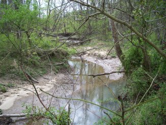
Headwaters of Casey Fork Creek in Southern Illinois
|
|
| Physical characteristics | |
| Main source | Haines Township, Marion County, Illinois 38°29′12″N 88°54′50″W / 38.4867155°N 88.9139508°W |
| River mouth | Confluence with Big Muddy River in Rend Lake 38°05′27″N 88°57′24″W / 38.0908831°N 88.956736°W |
| Length | 39 mi (63 km) |
Casey Fork is a stream in Illinois, United States. It flows into the Big Muddy River. The stream is about 39 miles (63 km) long. It gets its name from Zadok Casey, who was a congressman from Illinois a long time ago.
On official maps, it's called Casey Fork. This name was decided in 1967 by the U.S. Board on Geographic Names.
Contents
Where Casey Fork Flows
Casey Fork starts in Marion County. This is between the towns of Iuka and Kell. It flows south right through the middle of Kell as a small stream.
Ancient Lake Bed
Casey Fork flows through an old lake bed. This lake formed during the Wisconsin glaciation, which was a time when glaciers covered much of North America. This old lake bed makes the land around the creek very flat.
When there is a lot of rain, this flat area can fill with shallow water. The flat valley starts about 10 miles (16 km) north of Mt. Vernon. It is only a few hundred feet wide at first, but it gets wider as it goes south.
Railroads and Bluffs
The Union Pacific Railroad follows Casey Fork from Kell down to Mt. Vernon. This railroad was built around 1909. It crosses the creek many times as it goes downhill to Mt. Vernon.
The railroad route cuts into the hills next to the creek. This creates steep cliffs, also called bluffs. Another railroad, the Norfolk Southern, also enters the Casey Fork valley north of Mt. Vernon.
Near Mt. Vernon, Casey Fork flows between the two railroad tracks. When the creek floods, it can rage between these two railroad banks. There is a large bluff next to the Norfolk Southern tracks. Here, Casey Fork has worn away the rock, showing shale. This rock is part of the Pennsylvanian period, which has coal layers under Mt. Vernon.
Rend Lake Connection
South of Mt. Vernon, Casey Fork used to flow into an area called the Bakerville Bottoms. This was a natural swamp with hardwood trees that flooded often. Today, this area is part of Rend Lake.
Rend Lake was formed by building dams near where the Big Muddy River and Casey Fork meet. The eastern part of the lake used to be the Casey Fork bottomland. There is also a special dam called the Casey Fork Subimpoundment Dam. It creates a swamp upstream of Rend Lake. This swamp helps protect the lake from getting filled with dirt and mud.
Cities and Towns Along Casey Fork
Casey Fork helps drain water from these cities and towns:
Counties Drained by Casey Fork
Parts of these counties are drained by Casey Fork:
Lakes and Other Streams
Artificial Lakes
These lakes were made by people and are in the Casey Fork area:
- Jaycee Lake (also called Heil Lake)
- Miller Lake
- Rend Lake
Major Tributaries
The main streams that flow into Casey Fork are:
- Limestone Creek
- Seven Mile Creek
- Dodds Creek
- Atchison Creek
Gun Creek, which enters Rend Lake on the east side, might also be considered a part of the Casey Fork system.

