
Cashmere, Washington facts for kids
Quick facts for kids
Cashmere, Washington
|
|
|---|---|
 |
|

Location of Cashmere, Washington
|
|
| Country | United States |
| State | Washington |
| County | Chelan |
| Government | |
| • Type | Mayor–council |
| Area | |
| • Total | 1.21 sq mi (3.12 km2) |
| • Land | 1.16 sq mi (3.01 km2) |
| • Water | 0.04 sq mi (0.11 km2) |
| Elevation | 879 ft (268 m) |
| Population
(2020)
|
|
| • Total | 3,248 |
| • Estimate
(2019)
|
3,172 |
| • Density | 2,725.09/sq mi (1,052.44/km2) |
| Time zone | UTC-8 (Pacific (PST)) |
| • Summer (DST) | UTC-7 (PDT) |
| ZIP code |
98815
|
| Area code | 509 |
| FIPS code | 53-10495 |
| GNIS feature ID | 2409405 |
| Website | City of Cashmere |
Cashmere is a small city located in Chelan County, Washington, in the United States. It is part of the larger Wenatchee area. In 2020, about 3,248 people lived there.
Contents
History of Cashmere

Early People and the Land
Before 1850, a village called Ntuatckam existed where Cashmere is now. About 400 people lived there. These were the Wenatchi people, an Native American group. They lived off the land, hunting game and catching fish like coho, chinook, and sockeye salmon from the Wenatchee River. The river was very important to them.
Over time, dams on the Columbia River affected the fish. The Wenatchi people were later moved to the Colville Indian Reservation. However, they still have some rights to fish in the area.
First European Settlers
In the 1850s, a Catholic missionary named Father Respari was the first European to visit the Mission Valley. He lived with the Wenatchi people for 20 years, teaching them his religion. Later, in the 1870s, Father Urban Grassi built the St. Francis Xavier Mission in 1873.
After the missionaries left, ranchers and other settlers began to arrive in the 1880s. They built a one-room schoolhouse in 1886. This early settlement was known as Old Mission. In 1888, George Kline opened the first store, and a post office was set up. The town was then called "Mission."
Railroad and Water for Farms
In 1892, people learned that the Great Northern Railroad would build its main line through the valley. The town of Mission was planned near the railroad tracks, hoping for a train station. It didn't get a station right away, but by 1900, trains started making stops there. A small building for railroad workers was built, which you can still see today at the Cashmere Museum.
The railroad brought new life to the area. People wanted to bring water to the dry valley for farming. In 1892, a group was formed to dig the Peshastin Ditch. Many local men worked hard to dig this ditch, which was finished in 12 years. After the ditch brought water, the town and the whole area began to grow.
By the 1900s, Mission became a place where fruit and farm products were shipped out. As more people used the train, a bigger train station was built in 1903. This building is also still standing today.
Cashmere Gets Its Name
By 1903, the town had over 200 people. To avoid confusion with another town, Mission was renamed "Cashmere" that same year. A local judge thought the area looked like the foothills of Kashmir in Asia. The spelling was changed to "Cashmere" to sound more American.
Cashmere officially became a city in 1904. It continued to grow when the Mission Canal opened, turning dry land into rich farmland. Investors from Seattle bought land and built the town's first hotel and a saloon in 1905. A library was started in 1908 by the town's Woman's Club. By 1909, Cashmere had three banks. Telephone service came in 1909, followed by paved sidewalks in 1913, electric lights in 1914, and paved streets in 1919.
A Time of Change (1920s–1930s)
.jpg)
In August 1931, a special event called a pow wow took place in Cashmere. It lasted for three days. This gathering was held to remind people about promises made to the Wenatchi people that had not been kept, especially about their fishing rights. It also helped the local economy.
Many Native Americans attended, including about 250 Wenatchi people who traveled from other reservations. They set up tipis (traditional cone-shaped tents) in Yaksum canyon. Important leaders from other tribes and the state governor also came. Money raised from the event helped restore a local cemetery.
Farming and Timber
The Cashmere area is known for growing fruit, especially apples. When the Peshastin irrigation ditch was built in the 1890s, dry land became green orchards. Besides apples, the area is also great for growing pears, like Bartlett and D'Anjou varieties. Many orchards were opened in Cashmere starting in the 1910s because of the good climate.
Even though some orchards have been replaced by new buildings, you can still see many orchards and old fruit warehouses. The area's nice weather and beautiful scenery attract many people.
The area also has a history of timber production. Cashmere used to have a large sawmill. The first settlers found many ponderosa pine and Douglas-fir trees. These trees grew slowly in the dry climate, making their wood very strong and high quality.
Geography and Climate

Cashmere covers about 1.07 square miles (2.77 square kilometers). Most of this area is land, with a small part being water.
Weather in Cashmere
Cashmere has warm, dry summers. In recent years, summers have become even hotter. For example, on July 4, 2015, the temperature reached 106 degrees Fahrenheit (41 degrees Celsius). This type of weather is called a "warm-summer Mediterranean climate."
Economy
Cashmere is home to Liberty Orchards, a famous company that makes candies like Aplets & Cotlets. In 1997, the city even renamed two of its main streets to Aplets Way and Cotlets Avenue to support the company.
Cashmere is also where Cashmere Valley Bank started. It was founded in 1932 during the Great Depression when many banks were struggling. Today, it is one of the biggest banks in Central Washington.
Population Changes
| Historical population | |||
|---|---|---|---|
| Census | Pop. | %± | |
| 1910 | 625 | — | |
| 1920 | 1,114 | 78.2% | |
| 1930 | 1,473 | 32.2% | |
| 1940 | 1,465 | −0.5% | |
| 1950 | 1,768 | 20.7% | |
| 1960 | 1,891 | 7.0% | |
| 1970 | 1,976 | 4.5% | |
| 1980 | 2,240 | 13.4% | |
| 1990 | 2,544 | 13.6% | |
| 2000 | 2,965 | 16.5% | |
| 2010 | 3,063 | 3.3% | |
| 2020 | 3,248 | 6.0% | |
| U.S. Decennial Census | |||
Over the years, Cashmere's population has steadily grown. In 1910, there were 625 people, and by 2020, the population had reached 3,248.
Life in Cashmere
In 2010, there were 3,063 people living in Cashmere. The average age of people in the city was about 37.6 years old. About 25.9% of the residents were under 18, and 16% were 65 or older. The city had slightly more females (51.5%) than males (48.5%).
Arts and Culture
In downtown Cashmere, you can find the 9/11 Spirit of America Memorial. This monument honors the victims and first responders of the September 11, 2001 terrorist attacks. It includes pieces from the Twin Towers and The Pentagon. The memorial was dedicated in 2015 and is located next to Cashmere's Veterans War Memorial.

Fun Things to Do
Cashmere is surrounded by the eastern foothills of the Cascade Mountains, offering many outdoor activities. The Alpine Lakes Wilderness Area is only about 10 miles away to the west.
The Peshastin Pinnacles is a popular place for rock climbing, located just a few miles from town. Some of America's first technical climbing routes were set up here. The Devil's Gulch mountain bike trail, known as one of the best downhill rides in Washington, is also nearby. It attracts many mountain bikers every year.
The Wenatchee River flows right through Cashmere and is a great spot for whitewater rafting and kayaking. In the spring, when the snow melts, the river offers exciting rapids for adventurers.
Images for kids
-
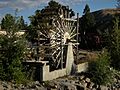
The Burbank Homestead Waterwheel at the Cashmere Museum, listed in the National Register of Historic Places (NRHP)
See also
 In Spanish: Cashmere (Washington) para niños
