
Castle Rock (Chelan County) facts for kids
Quick facts for kids Castle Rock |
|
|---|---|

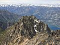
Castle Rock from Lake Chelan
|
|
| Highest point | |
| Elevation | 8,137 ft (2,480 m) |
| Prominence | 537 ft (164 m) |
| Parent peak | Flora Mountain 8320 ft |
| Geography | |

Castle Rock
Location in Washington (state)

Castle Rock
Location in the United States
|
|
| Parent range | North Cascades Cascade Range |
| Topo map | USGS Stehekin |
| Climbing | |
| First ascent | 1917 by Geodetic Surveyr |
| Easiest route | Scrambling class 2-3 |
Castle Rock is an 8,137-foot (2,480-metre) mountain peak in Washington state. It sits on the edge of the Glacier Peak Wilderness and the Lake Chelan National Recreation Area. This amazing peak is part of the North Cascades mountain range.
You can find Castle Rock above the western shore of Lake Chelan in Chelan County. The land around it is managed by the Wenatchee National Forest. The closest taller mountain is Flora Mountain, which is about 0.7 mi (1.1 km) to the south. Water from the peak flows into Lake Chelan through Castle Creek, Canyon Creek, and Bridal Veil Creek.
Understanding the Weather at Castle Rock
Most weather systems start over the Pacific Ocean. They then travel northeast towards the Cascade Mountains. When these weather systems reach the North Cascades, the tall mountains force the air upwards. This process, called orographic lift, makes the air cool down and drop its moisture. This means a lot of rain or snow falls on the Cascades.
Because of this, the North Cascades get a lot of precipitation, especially snow in winter. Winter days are often cloudy. However, during summer, high-pressure systems over the Pacific Ocean become stronger. This often leads to clear skies and sunny weather.
How Castle Rock Was Formed
The North Cascades mountains have some of the most rugged land in the Cascade Range. You can see sharp peaks, tall spires, long ridges, and deep valleys carved by glaciers. These different shapes and huge changes in height were created by geological events millions of years ago. These events also led to the different climates we see across the Cascade Range.
The Cascade Mountains began to form millions of years ago, during a time called the late Eocene Epoch. This happened because the North American Plate was slowly moving over the Pacific Plate. This movement caused many periods of volcanic activity, where molten rock came to the surface. For example, Glacier Peak, a large stratovolcano, started forming about 21 mi (34 km) southwest of Tupshin Peak during the mid-Pleistocene period.
Also, small pieces of the Earth's crust, called terranes, came together to form the North Cascades about 50 million years ago.
During the Pleistocene period, which was over two million years ago, glaciers repeatedly moved across the land. As they advanced and retreated, they scraped and shaped the landscape. They left behind piles of rock and debris. The "U"-shaped valleys you see today were formed by these glaciers. The combination of land being pushed upwards (called uplift) and cracks forming in the Earth's crust (called faulting), along with the action of glaciers, created the tall peaks and deep valleys of the North Cascades.
Images for kids
-
Castle Rock summit view

