Castle Rock (Utah) facts for kids
Quick facts for kids Castle Rock |
|
|---|---|

Southwest aspect
|
|
| Highest point | |
| Elevation | 4,321 ft (1,317 m) |
| Prominence | 701 ft (214 m) |
| Isolation | 1.63 mi (2.62 km) |
| Parent peak | Point 4380 |
| Geography | |
| Location | Glen Canyon National Recreation Area Kane County, Utah, U.S. |
| Parent range | Colorado Plateau |
| Topo map | USGS Warm Creek Bay |
| Geology | |
| Age of rock | Jurassic |
| Type of rock | Entrada Sandstone |
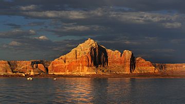
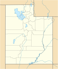
Castle Rock is a tall rock formation in southern Utah. It stands 4,321 feet (1,317 meters) high. You can find it in the Glen Canyon National Recreation Area. This area is part of Kane County.
Castle Rock is about 6.5 miles north of Page. It is also 2.5 miles northeast of the Wahweap marina. The rock towers over 600 feet above Lake Powell. When the lake is full, Castle Rock becomes an island!
This amazing landmark is mostly made of a rock called Entrada Sandstone. This sandstone formed about 160 million years ago. That was during the Jurassic period, when dinosaurs roamed the Earth. Back then, this area was a huge sand sea. It was the biggest sand sea in Earth's history.
Contents
Exploring Castle Rock's Location
Castle Rock is a well-known spot. It is easy to see from many places around Lake Powell. The rock is a popular sight for visitors. Many people enjoy boating near it.
Where is Castle Rock?
Castle Rock is in Utah, a state in the western United States. It is part of the Colorado Plateau. This is a large area of high desert. The plateau is known for its unique rock formations.
Nearby Towns and Water
The town of Page, Arizona, is close by. It is a good starting point for visiting the area. The Wahweap marina is also very near. This is where many boats launch onto Lake Powell. Lake Powell is a large man-made lake. It was created by damming the Colorado River.
Weather at Castle Rock
The weather around Castle Rock is usually dry. It has a desert climate. This means summers are hot and very dry. Winters are chilly, but there is not much snow.
Best Times to Visit
Spring and fall are the best times to visit Castle Rock. The weather is mild and pleasant then. It is perfect for exploring the area.
Average Temperatures
The data below shows the typical weather. It is from the Wahweap climate station. This station is just two miles from Castle Rock.
| Climate data for Wahweap, AZ | |||||||||||||
|---|---|---|---|---|---|---|---|---|---|---|---|---|---|
| Month | Jan | Feb | Mar | Apr | May | Jun | Jul | Aug | Sep | Oct | Nov | Dec | Year |
| Record high °F (°C) | 69 (21) |
78 (26) |
85 (29) |
94 (34) |
104 (40) |
110 (43) |
120 (49) |
115 (46) |
105 (41) |
96 (36) |
80 (27) |
70 (21) |
120 (49) |
| Mean daily maximum °F (°C) | 47.2 (8.4) |
53.8 (12.1) |
63.0 (17.2) |
72.8 (22.7) |
83.8 (28.8) |
94.1 (34.5) |
98.8 (37.1) |
95.7 (35.4) |
87.7 (30.9) |
73.7 (23.2) |
58.3 (14.6) |
47.1 (8.4) |
73.0 (22.8) |
| Mean daily minimum °F (°C) | 26.9 (−2.8) |
31.8 (−0.1) |
37.8 (3.2) |
44.6 (7.0) |
54.9 (12.7) |
64.1 (17.8) |
71.3 (21.8) |
69.3 (20.7) |
60.7 (15.9) |
48.9 (9.4) |
36.9 (2.7) |
27.4 (−2.6) |
47.9 (8.8) |
| Record low °F (°C) | −2 (−19) |
4 (−16) |
21 (−6) |
16 (−9) |
29 (−2) |
40 (4) |
48 (9) |
51 (11) |
36 (2) |
24 (−4) |
15 (−9) |
3 (−16) |
−2 (−19) |
| Average precipitation inches (mm) | 0.59 (15) |
0.56 (14) |
0.63 (16) |
0.37 (9.4) |
0.36 (9.1) |
0.17 (4.3) |
0.51 (13) |
0.75 (19) |
0.59 (15) |
0.85 (22) |
0.57 (14) |
0.41 (10) |
6.36 (160.8) |
| Average snowfall inches (cm) | 0.2 (0.51) |
0.2 (0.51) |
0 (0) |
0 (0) |
0 (0) |
0 (0) |
0 (0) |
0 (0) |
0 (0) |
0 (0) |
0 (0) |
0.3 (0.76) |
0.7 (1.78) |
| Source: http://www.wrcc.dri.edu/cgi-bin/cliMAIN.pl?az9114 | |||||||||||||
Gallery
 | Victor J. Glover |
 | Yvonne Cagle |
 | Jeanette Epps |
 | Bernard A. Harris Jr. |


