
Catoosa, Oklahoma facts for kids
Quick facts for kids
Catoosa, Oklahoma
|
|
|---|---|
.jpg)
Aerial view of Catoosa
|
|

Location of Catoosa, Oklahoma
|
|
| Country | United States |
| State | Oklahoma |
| Counties | Rogers, Wagoner |
| Government | |
| • Type | Council-Manager |
| Area | |
| • Total | 11.96 sq mi (30.98 km2) |
| • Land | 11.94 sq mi (30.92 km2) |
| • Water | 0.02 sq mi (0.06 km2) |
| Elevation | 669 ft (204 m) |
| Population
(2020)
|
|
| • Total | 7,440 |
| • Density | 623.12/sq mi (240.59/km2) |
| Time zone | UTC-6 (Central (CST)) |
| • Summer (DST) | UTC-5 (CDT) |
| ZIP code |
74015
|
| Area code(s) | 539/918 |
| FIPS code | 40-12900 |
| GNIS feature ID | 2409413 |
Catoosa is a city in the state of Oklahoma, USA. It is located in Rogers and Wagoner counties. In 2020, about 7,440 people lived there. This was a small increase from 7,159 people in 2010.
Contents
History of Catoosa
Early Days and Name Origin
The Cherokee Nation used to control this area in the 1800s. When the Atlantic and Pacific Railroad built train tracks in the early 1880s, Catoosa became a "cow town." This meant it was a place where cattle were gathered and shipped. A post office opened here in 1883.
The name Catoosa comes from the Cherokee language. It sounds like "Ga-du-si" or "Ga-tu-si." People have different ideas about what it means. Some think it means "between two hills" or "on the hill." It might also mean a special hill or a place on it.
Growth and the Port
Catoosa started with 241 people in 1900. By 1910, its population grew to 410. The town's economy included a grain elevator and a cotton mill. There were also some coal mines nearby.
A big change happened in 1971 when the Tulsa Port of Catoosa opened. This port helped the town's economy grow a lot. The port has a large industrial park. By the 2000s, over 2,600 people worked there. By 2013, it had 70 businesses and over 4,000 workers. The port connects to the Mississippi River and the Gulf of Mexico. This is through the McClellan-Kerr Arkansas River Navigation System.
Weather Event
On April 24, 1993, a very strong tornado hit Catoosa. It was an F4 tornado, which means it was very powerful. The tornado caused a lot of damage, estimated at $500,000. After the tornado, 100 National Guard troops came to help the town.
Geography and Location
Catoosa is about 14 miles (23 km) northeast of Tulsa, Oklahoma. It is in Rogers County, Oklahoma. This location is great because it gives mid-America access to river shipping. This happens at the Tulsa Port of Catoosa. The city covers about 7 square miles (18 km2) of land. Only a very small part is water.
The Inland Seaport
Catoosa has an inland seaport. It is the end point of the Kerr-McClellan Arkansas River Navigation System. The Port of Catoosa is one of the farthest inland seaports in the United States. It links Tulsa to the Arkansas River. From there, ships can reach the Mississippi River and then the Gulf of Mexico.
Transportation Links
Catoosa is connected by the South Kansas and Oklahoma Railroad. This railroad goes through Owasso to Tulsa and other places north. The city is also located along historic Route 66.
Population Changes
| Historical population | |||
|---|---|---|---|
| Census | Pop. | %± | |
| 1900 | 241 | — | |
| 1910 | 404 | 67.6% | |
| 1920 | 363 | −10.1% | |
| 1930 | 264 | −27.3% | |
| 1940 | 405 | 53.4% | |
| 1950 | 438 | 8.1% | |
| 1960 | 638 | 45.7% | |
| 1970 | 970 | 52.0% | |
| 1980 | 1,561 | 60.9% | |
| 1990 | 2,954 | 89.2% | |
| 2000 | 5,449 | 84.5% | |
| 2010 | 7,159 | 31.4% | |
| 2020 | 7,440 | 3.9% | |
| U.S. Decennial Census | |||
In 2010, there were 7,151 people living in Catoosa. There were 2,581 homes. The population density was about 639 people per square mile (247 per km2). The city's population has grown a lot over the years. For example, it grew from 241 people in 1900 to 7,440 in 2020.
Education in Catoosa
In 2000, the Catoosa School District had 2,416 students. By 2011, Catoosa High School had 609 students. There were about 13 students for every teacher.
Local Media
Catoosa used to have a newspaper called the Catoosa Times. It was published every Wednesday. The newspaper stopped publishing at the end of 2013.
Fun Places to Visit
- The Blue Whale of Catoosa is a very famous landmark on Route 66. It is just east of the downtown area.
- The Hard Rock Casino (also known as Cherokee Casino and Resort) is in Catoosa. The Cherokee Nation runs it. It has hotels, restaurants, a golf course, and a concert hall. It also hosts art and film festivals.
- The Catoosa Historical Museum looks like an old train station. It has many old items from Catoosa and railroad things. You can spot it by the Burlington Northern Railroad caboose outside.
- The D.W. Correll Museum has old cars and a large collection of rocks and minerals. Mr. D.W. Correll started it, and now the City of Catoosa runs it.
- Gazebo Park
- Hathaway Park
- J.B. Hamby Park
- Redbud Valley Nature Preserve Center and Hiking Trails
- Rodger Berry Sports Complex
Images for kids
-
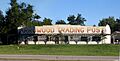
Arrowood Trading Post
-
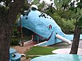
The Blue Whale of Catoosa


See also
 In Spanish: Catoosa (Oklahoma) para niños
