
Centerville, Utah facts for kids
Quick facts for kids
Centerville, Utah
|
|
|---|---|
|
City
|
|
| City of Centerville | |

Centerville City Hall, August 2008
|
|
| Nickname(s):
C-Ville
|
|
| Motto(s):
Making Life Better
|
|

Location in Davis County and the state of Utah.
|
|
| Country | United States |
| State | Utah |
| County | Davis |
| Area | |
| • Total | 6.03 sq mi (15.61 km2) |
| • Land | 5.96 sq mi (15.45 km2) |
| • Water | 0.06 sq mi (0.17 km2) |
| Elevation | 4,246 ft (1,294 m) |
| Population
(2010)
|
|
| • Total | 15,335 |
| • Estimate
(2019)
|
17,587 |
| • Density | 2,948.86/sq mi (1,138.52/km2) |
| Time zone | UTC-7 (Mountain (MST)) |
| • Summer (DST) | UTC-6 (MDT) |
| ZIP code |
84014
|
| Area codes | 385, 801 |
| FIPS code | 49-11980 |
| GNIS feature ID | 2409425 |
Centerville is a city in southeastern Davis County, Utah, United States. It is part of the larger Ogden-Clearfield Metropolitan Statistical Area. In 2010, about 15,335 people lived here. Centerville is located right next to the eastern part of the Great Salt Lake.
Contents
History of Centerville
Centerville was first settled in the fall of 1847 by Thomas Grover. The community was first called Deuel Settlement. Later, it was renamed Cherry Creek after the Cherry family moved there. In 1850, a survey found the town was exactly between Farmington and Bountiful. Because of its central location, it became known as Centerville, and that name stuck.
- In 1849, Shadrach Roundy and his family farmed near Centerville. He built a mill on Deuel Creek in the winter of 1849. He also made molasses from corn plants at this mill.
- A log school house was built in Centerville in 1851. It was replaced by a building made of adobe in 1854. A much larger building was built in 1862.
- B. H. Roberts, an important leader in the Latter-day Saint church, lived in Centerville.
- In 1869, the Utah Central Rail Road reached Centerville. This helped the town grow.
- Centerville officially became a city on May 4, 1915, when the State of Utah approved it.
- In 1983, a lot of rain caused mudslides and floods in Centerville and other parts of Northern Utah.
- In December 2011, a very strong wind storm hit the area. It caused power outages and over $8 million in damage.
Church History in Centerville
The first group of the Church of Jesus Christ of Latter-day Saints (LDS Church) in Centerville was formed in 1850. In 1852, Centerville became a ward, which is a local church congregation. Today, there are four larger church groups, called stakes, of the LDS Church in Centerville.
Geography and Climate
Centerville covers about 6 square miles (15.6 square kilometers) of land.
Centerville's Climate
Centerville has hot and dry summers. Its winters are cool and snowy. The climate is often described as Mediterranean or humid continental.
| Climate data for Centerville, Utah, USA | |||||||||||||
|---|---|---|---|---|---|---|---|---|---|---|---|---|---|
| Month | Jan | Feb | Mar | Apr | May | Jun | Jul | Aug | Sep | Oct | Nov | Dec | Year |
| Record high °F (°C) | 62 (17) |
72 (22) |
79 (26) |
86 (30) |
96 (36) |
102 (39) |
106 (41) |
102 (39) |
99 (37) |
90 (32) |
77 (25) |
79 (26) |
106 (41) |
| Mean daily maximum °F (°C) | 37.8 (3.2) |
43.2 (6.2) |
52.3 (11.3) |
62.7 (17.1) |
72.8 (22.7) |
82.4 (28.0) |
91.5 (33.1) |
89.1 (31.7) |
79.1 (26.2) |
66.2 (19.0) |
50.8 (10.4) |
40.1 (4.5) |
64.0 (17.8) |
| Daily mean °F (°C) | 28.6 (−1.9) |
33.5 (0.8) |
41.1 (5.1) |
49.8 (9.9) |
58.4 (14.7) |
66.6 (19.2) |
74.9 (23.8) |
72.8 (22.7) |
63.1 (17.3) |
52 (11) |
39.6 (4.2) |
31.1 (−0.5) |
51 (11) |
| Mean daily minimum °F (°C) | 19.1 (−7.2) |
23.8 (−4.6) |
29.9 (−1.2) |
37 (3) |
44 (7) |
50.8 (10.4) |
58.3 (14.6) |
56.5 (13.6) |
47.1 (8.4) |
37.9 (3.3) |
28.4 (−2.0) |
22.1 (−5.5) |
37.9 (3.3) |
| Record low °F (°C) | −20 (−29) |
−20 (−29) |
1 (−17) |
12 (−11) |
26 (−3) |
30 (−1) |
36 (2) |
36 (2) |
23 (−5) |
16 (−9) |
−8 (−22) |
−16 (−27) |
−20 (−29) |
| Average precipitation inches (mm) | 2.2 (56) |
2.1 (53) |
2.2 (56) |
2.3 (58) |
2.2 (56) |
1.1 (28) |
0.5 (13) |
1.1 (28) |
1.0 (25) |
1.6 (41) |
1.8 (46) |
1.9 (48) |
20 (508) |
| Average snowfall inches (cm) | 19 (48) |
11.2 (28) |
11.4 (29) |
3.2 (8.1) |
.5 (1.3) |
0 (0) |
0 (0) |
0 (0) |
0 (0) |
0.7 (1.8) |
5.6 (14) |
12.5 (32) |
64.1 (162.2) |
| Average rainy days | 9 | 9 | 9 | 8 | 8 | 4 | 3 | 4 | 4 | 5 | 7 | 9 | 79 |
| Average snowy days | 5.6 | 3.3 | 1.6 | .6 | 0 | 0 | 0 | 0 | 0 | .1 | 2 | 4.3 | 17.5 |
Population of Centerville
| Historical population | |||
|---|---|---|---|
| Census | Pop. | %± | |
| 1860 | 475 | — | |
| 1870 | 544 | 14.5% | |
| 1880 | 529 | −2.8% | |
| 1890 | 532 | 0.6% | |
| 1900 | 640 | 20.3% | |
| 1910 | 791 | 23.6% | |
| 1920 | 787 | −0.5% | |
| 1930 | 670 | −14.9% | |
| 1940 | 691 | 3.1% | |
| 1950 | 1,263 | 82.8% | |
| 1960 | 2,361 | 86.9% | |
| 1970 | 3,268 | 38.4% | |
| 1980 | 8,069 | 146.9% | |
| 1990 | 11,500 | 42.5% | |
| 2000 | 14,585 | 26.8% | |
| 2010 | 15,335 | 5.1% | |
| 2020 | 16,884 | 10.1% | |
| U.S. Decennial Census | |||
In 2000, there were 14,585 people living in Centerville. About 51.5% of homes had children under 18. Most households (76.1%) were married couples living together. The average household had about 3.52 people.
The population was spread out by age. About 35.9% were under 18 years old. The median age was 27 years. This means half the people were younger than 27 and half were older.
Economy and Businesses
Parrish Lane is a very busy road in Centerville. It connects I-15 to SR-106. In 2008, it was extended to connect to the new Legacy Parkway.
Today, Parrish Lane is Centerville's main business area. You can find large stores and many smaller shops and restaurants there. There are also many local businesses like dentists, doctors, and chiropractors. Other businesses, such as real estate and insurance offices, are also located in the city.
Schools in Centerville
Centerville has five public schools. The closest high school is Viewmont High School. It is located south of Centerville in Bountiful. There are four elementary schools: Jennie P. Stewart, J.A. Taylor, Reading, and Centerville Elementary. There is also one junior high school, Centerville Junior High, for grades 7-9.
Gallery
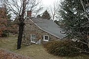
Some sites in Centerville are listed on the National Register of Historic Places.
-
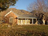
Barnard-Garn-Barber House
-
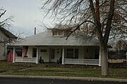
Thomas and Margaret Brandon House
-
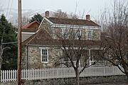
William Capener House
-
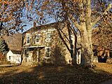
Osmyn and Emily Deuel House
-
John, Harriet, and Eliza Jennett Duncan House


See also
 In Spanish: Centerville (Utah) para niños
