Cerro Toco facts for kids
Quick facts for kids Cerro Toco |
|
|---|---|

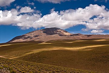
Cerro Toco lies at the NE end of the Purico complex. Camera location: 22° 55.411'S 7° 50.699'W Heading: 112° Alt.: 4,351 m (14,275 ft)
|
|
| Highest point | |
| Elevation | 5,604 m (18,386 ft) |
| Geography | |
| Location | Chile |
| Parent range | Andes |
| Geology | |
| Mountain type | Stratovolcano |
Cerro Toco is a stratovolcano, which is a tall, cone-shaped volcano. It is found in the eastern part of the Atacama desert in Chile. This area is known as Chile's II Region, or Antofagasta. Cerro Toco is about 6 km (4 mi) south of the border between Bolivia and Chile. It is also about 12 km (7 mi) southeast of the Juriques and Licancabur volcanoes. Cerro Toco marks the northeastern end of the Purico Complex. This complex is a large area made of several volcanoes, lava domes, and a maar (a type of wide, flat-bottomed volcanic crater).
Where is Cerro Toco Located?
Cerro Toco is part of the Chajnantor Scientific Reserve. Most of the Purico Complex is also within this special reserve. This area is very high and dry, making it perfect for studying space.
Observatories on Cerro Toco
On the western side of Cerro Toco, at about 5,200 m (17,100 ft) elevation, you can find important telescopes. These include the Atacama Cosmology Telescope and the Huan Tran Telescope. Scientists use these telescopes to learn more about the universe.
See also
 In Spanish: Cerro Toco para niños

- List of volcanoes in Chile
- Purico Complex
- Licancabur
- Juriques
- Laguna Verde (Bolivia)
 | Emma Amos |
 | Edward Mitchell Bannister |
 | Larry D. Alexander |
 | Ernie Barnes |


