Purico complex facts for kids
Quick facts for kids Puricó complex |
|
|---|---|
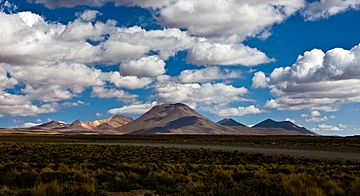
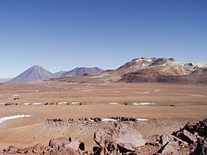
The southwest part of the complex is formed by the cinder cone Cerro Negro and the stratovolcano Cerros de Macón.
|
|
| Highest point | |
| Elevation | 5,703 m (18,711 ft) |
| Geography | |
| Location | Chile |
| Geology | |
| Age of rock | Holocene |
| Mountain type | Pyroclastic shield, volcanic complex |
The Purico complex is a group of volcanoes in Chile, near the border with Bolivia. It formed a long time ago, during the Pleistocene epoch. This complex includes a large sheet of volcanic rock called an ignimbrite, several lava domes, and stratovolcanoes. It also has one maar, which is a wide, flat volcanic crater.
Purico is part of the Central Volcanic Zone, which is one of four main volcanic areas in the Andean Volcanic Belt. This zone stretches across Peru, Bolivia, Chile, and Argentina. It has 44 active volcanoes and many large calderas, which are huge bowl-shaped volcanic craters.
The Purico complex looks like a shield, made mostly of the Purico ignimbrite. Many smaller volcanoes grew on top of this shield. Long ago, during the ice ages, glaciers covered parts of the shield. These glaciers left behind piles of rock and dirt called moraines.
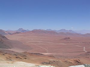
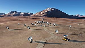
The Purico ignimbrite is very large, with a volume of about 80 to 100 cubic kilometers. After this huge eruption, new lava domes and stratovolcanoes formed on the shield. One part, the Alitar maar, still has active fumaroles, which are vents that release steam and gases. In the past, people mined sulfur here. Today, the Llano de Chajnantor Observatory, a famous place for looking at space, is located on the Purico ignimbrite shield.
Contents
Where is Purico and What Does It Look Like?
The Purico complex is in Chile, close to the border with Bolivia. It is east of San Pedro de Atacama and northeast of Toconao. You can even see the volcanic complex from San Pedro de Atacama. A road goes around the northern and eastern sides of Purico. A gas pipeline also crosses through the complex. Scientists first learned about the Purico complex by looking at satellite images.
Purico's Volcanic Neighbors
The Licancabur volcano sits just north of Purico, built on top of Purico's ignimbrites. To the east is Guayaques volcano. The La Pacana caldera is southeast of Purico. Its Filo Delgado ignimbrite even covers some parts of the Purico ignimbrite. Other well-known volcanoes like Lascár and El Tatio are further away.
Purico is part of the Central Volcanic Zone (CVZ). This volcanic belt is about 1,500 kilometers long. It runs along the western side of South America. The CVZ is one of four separate volcanic belts in the Andean Volcanic Belt. These belts are separated by areas where no recent volcanoes exist. The CVZ has 44 active volcanoes and 18 smaller volcanic spots. It also has over 6 large systems of ignimbrites or calderas. One of these volcanoes, Ojos del Salado, is the highest volcano in the world. The biggest eruption in the CVZ happened in 1600 at Huaynaputina in Peru. Lascár is the most active volcano in this zone, with a major eruption in 1993.
Inside the Purico Complex
Purico is a round, shield-shaped volcano about 15 to 25 kilometers wide. Its slopes gently go down from a center that is about 5,000 meters high. This shield forms a flat area called the Chajnantor Plateau. Other flat areas like Llano de Chajnantor are also found here. Unlike many volcanoes of this type, there is no sign of a large caldera here. To the west, the shield slopes down towards the Salar de Atacama salt flat. A system of cracks and faults runs across the western edge of the Purico complex.
On top of this shield, there is a group of lava domes and lava flows. These reach heights of over 5,800 meters above sea level. The main vent that erupted the ignimbrite might be buried under this group of domes. This group forms a semicircle about 10 by 20 kilometers wide. It opens to the southwest, which might show where a ring-shaped crack in the ground is.
Going clockwise from the west, this semicircle includes several peaks. There is 5,016-meter-high Cerro Negro and Cerro Purico. Then there is "dacite dome D" and 5,639-meter-high El Cerillo, also called Cerro Chajnantor. Next is 5,703-meter-high Cerro El Chascon. To the south are 5,262-meter-high Cerro Aspero and 5,462-meter-high Cerro Putas. Most of these domes are cone-shaped, except for the flat "dacite dome D". Aspero, El Cerillo, and El Chascon seem to have formed after the last ice age.
The Chascon dome is made of lava flows and has a clear summit crater at its top. Cerro Purico is a stratovolcano, also known as Cerro Toco. Other smaller features in the main complex include 5,058-meter-high Cerro Agua Amarga. There is also the Cordon Honor with Cerro Purico Sur in the "opening" of the semicircle. Mudflows and debris flows from the volcanoes have covered parts of the ignimbrite shield with gravel. A spring fed by melting snow on Cerro Toco is called Aguada Pajaritos. A small lake called Laguna de Agua Amarga is south of Chascon. The Purico complex now acts as a water divide. It separates water flowing towards the Salar de Atacama from water flowing to the Salar de Pujsa. The 5,130-meter-high Macon stratovolcano, Alitar maar, and 5,346-meter-high Alitar volcano are south of the main complex. The Alitar maar is 500 meters wide and 50 meters deep.
How Purico Formed
The Nazca Plate is slowly sliding under the South America Plate off the coast of South America. This process, called subduction, causes volcanoes to form in the Andean Volcanic Belt.
Volcanic activity in the Central Volcanic Zone has been happening for 200 million years. About 23 million years ago, huge ignimbrite eruptions began in the area. Later, around 17-15 million years ago, more eruptions happened. However, most of the volcanic activity until the late Miocene involved slow flows of andesitic lava.
Purico and the Andes Volcanoes
Purico seems to be part of a group of large volcanoes. These volcanoes formed huge calderas and erupted dacitic ignimbrites. This group is known as the Altiplano-Puna volcanic complex. It includes volcanoes like Cerro Guacha and La Pacana. These volcanoes are clustered around the point where Argentina, Bolivia, and Chile meet. The dry climate here means that most volcanoes are well preserved.
This whole complex sits on top of a large body of molten rock, or magma. This magma body is about 15 to 35 kilometers deep. It is where magma from deep inside the Earth mixes with the Earth's crust. This mixing creates the different types of magma that erupt from these volcanoes. Scientists have seen this magma body using special imaging techniques.
Large ignimbrite eruptions in these systems happen in bursts. These bursts are separated by quieter times with less volcanic activity. The eruption of the Purico ignimbrite was the most recent large ignimbrite eruption in the Altiplano-Puna volcanic complex. The complex is currently in a quieter phase. However, active hot springs show that magma is still moving underground.
What is Purico Made Of?
The Purico complex has erupted different types of molten rock. These range from the dacitic Purico ignimbrite to rhyolitic pumices and andesitic-dacitic rocks that formed after the ignimbrite. Dacite is the most common type of rock. It is rich in crystals and potassium. The rocks from Purico contain various crystals. These include minerals like biotite, quartz, and plagioclase.
Small pieces of darker, mafic rock are also found in the Purico ignimbrite. These are common in rocks from volcanic arcs. They are even more common in rocks from Chascon. This might mean that mafic magma was present before Chascon formed.
Scientists have figured out some properties of the Purico magmas. The dacite magma was about 750 to 810 degrees Celsius. The andesite and rhyolite magmas were hotter, up to 800 to 880 degrees Celsius. The magma contained a small amount of water, but very little carbon dioxide.
Weather and Life Around Purico
The climate at Purico is very cold, with average temperatures around -3 to -4 degrees Celsius. The air is thin because of the high elevation. There is also a lot of ultraviolet radiation from the sun. Not much rain falls here, about 200 millimeters per year on the higher parts. Closer to the Salar de Atacama, it's even drier, with less than 10 millimeters per year. Most rain happens in the summer due to the South American monsoon. Snow also falls in winter, but it mostly evaporates. Summer snow melts. This dry climate is caused by several factors, including the Humboldt Current in the Pacific Ocean and the rain shadow from the Andes mountains. However, in the past, there were wetter periods.
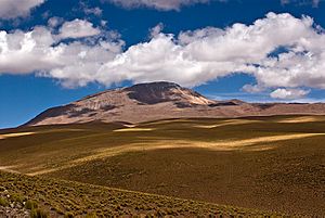
Because of the dry climate and high elevation, there isn't much plant life. You can find cacti like Echinopsis atacamensis and grasses at lower elevations. The few plants that are there grow in different zones based on height. There's a lower "Prepuna" zone with shrubs, a middle "Puna" zone with grasses and shrubs, and a "high Andean steppe" with bunch grass. In 1993, a report noted red-brown cacti and brown grass growing around the base of Purico.
Even though it's a harsh environment, the soils on the Purico complex have many different microbes. These microbes can survive extreme conditions. Some bacteria found here include Amycolatopsis vastitatis and Streptomyces aridus. Some of these microbes produce compounds that could be useful in medicine.
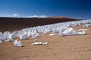
During the ice ages, there was more moisture, which led to glaciers forming on Purico. At times, an ice cap covered an area of 200 to 250 square kilometers at 5,000 meters elevation. It seems there were three different periods of glaciation. The most recent was about 30,000–25,000 years ago. These glaciations left behind moraines on Purico. These moraines are piles of rock and dirt that stretch for many kilometers. They are found at altitudes of 4,400 to 4,600 meters, sometimes even lower. The moraines can be 10 meters high on the eastern side and 2 to 5 meters high on the western side. They are covered with large rocks and have scratched surfaces from the moving ice. Tall, thin snow formations called Penitentes still appear on Purico today.
Purico's Volcanic Past
The Purico complex is the source of the huge Purico ignimbrite. This ignimbrite erupted around the time of the Jaramillo reversal, a period when Earth's magnetic field flipped. The Purico ignimbrite covers an area of 1,500 square kilometers. Its volume is estimated to be 80 to 100 cubic kilometers. It is up to 250 meters thick near the center. It gets thinner further away, reaching 25 meters thick in some places. Scientists have used Potassium-argon dating to find its age, which is between 1.38 million and 0.87 million years old. The "dacitic dome D," which is 2 cubic kilometers large, is about 0.98 million years old. It might have formed at the same time as the ignimbrites. The eruption of the Purico ignimbrite was part of a burst of activity in the Altiplano-Puna volcanic complex about 1 million years ago.
The Purico ignimbrite has three main layers, or flow units. These are the two Lower Purico Ignimbrites and the Upper Purico Ignimbrite. The Upper ignimbrite is 10 to 12 meters thick. The two lower ones together are about 30 meters thick on average, up to 80 meters thick. The very bottom layer is a single flow. The upper Lower Purico Ignimbrite is more mixed. It starts with a fast-moving cloud of gas and ash, then a layer of pumice, and then another flow. This last flow is the largest part. The Lower Purico Ignimbrite covers 800 square kilometers, mostly on the western side of Purico. Finally, the Upper Purico Ignimbrite is a dense, welded flow. It is found mainly near the top of the Purico complex. It has six flow units and special textures called fiamme. A unique feature of the Purico ignimbrite is its "banded" pumice. These pumice pieces have alternating dark and bright parts. The eruption of the Purico ignimbrite also released a lot of tephra (ash and rock fragments). Some of this tephra fell as far away as the Chilean Coast Range to the west.
After the eruption, rivers carved winding channels into the ignimbrites. Unlike other ignimbrites in the area, there is little sign of wind erosion on the Purico ignimbrite. Wind erosion takes a long time, so the Purico ignimbrite might be too young to have been changed much by wind. Some parts of the ignimbrite have been smoothed by glaciers.
Scientists believe the structure of the ignimbrite tells us about the magma chamber below. Before the Purico ignimbrite erupted, a dacitic magma chamber already existed. When new, andesitic magma entered this chamber, it pushed the dacitic magma upwards. This caused the eruption of the lowermost Lower Purico Ignimbrite. The new magma quickly heated the dacite and added more gas. This led to a powerful Plinian eruption with a tall eruption column. As the eruption continued, it pulled up denser dacitic magma. This caused the column to collapse, forming the Upper Purico Ignimbrite and the "dacite dome D".
Volcanoes After the Big Blast
Volcanic activity after the main ignimbrite eruption is divided into two groups. The older group is the andesitic Purico group. It includes Cerro Negro, Cerro Purico, Putas, and Cerro Toco. These are polygenetic volcanoes, meaning they formed from many eruptions. The younger group is the Chascon group. It includes Aspero, El Cerillo/Chajnantor, and El Chascon. These are lava dome and lava flow structures. The Chascon group is also the only one that contains mafic xenoliths, which are pieces of darker, older rock.
The Cerro Purico and Macon volcanoes formed soon after, or even before, the ignimbrites. They are old volcanoes and have been heavily eroded. They show signs of moraines from glaciers. Their rocks also show hydrothermal alteration from fumarolic activity. This alteration, along with sulfur from fumaroles, created the sulfur deposits at Purico.
Aspero, Cerro El Chascon, Cerros El Negro, and Putas are younger. They do not show signs of glaciation. El Chascon, in particular, might be only tens of thousands of years old. It has a clear summit crater and fresh-looking lava flows. Aspero was once thought to be from the Holocene period because it and Chascon lie on top of moraines. Later, scientists dated Aspero and Chascon to about 180,000 years ago. There are no other dates for the volcanoes that formed after the ignimbrite. The Alitar volcano is thought to be from the Plio-Pleistocene age. This period of eruptions was more recent than the Purico ignimbrite. It might have been caused by mafic magma entering the Purico system. These later eruptions were much smaller, with volumes ranging from 0.36 to 4 cubic kilometers.
This change in eruption style, from huge ignimbrites to smaller domes, shows a change in how magma was supplied. Before, there was a large flow of magma that mixed a lot with the Earth's crust, leading to the ignimbrites. Later, there were smaller flows in a colder, more brittle crust. These smaller flows did not build up as much or mix as much with the crust. So, the later volcanic rocks seem more basic and less changed by crustal material.
Is Purico Still Active?
The Macon stratovolcano is considered to be from the Holocene period (our current geological period). The Alitar maar still has active fumaroles and hot springs. There are no known historical eruptions from Alitar. There are also no signs of seismic activity (earthquakes) in the Purico area. If Alitar were to become active again, it would likely be small phreatic eruptions. These are steam explosions that happen when magma heats groundwater.
The fumaroles at Alitar are mainly in its northern and eastern parts. The hot springs are in the Quepiaco creek area, about 250 meters southwest of Alitar. They have six small vents. The temperatures of the Alitar vents are between 54 and 57 degrees Celsius. The gases from the fumaroles are mostly water vapour, with some carbon dioxide. Sulfur also forms here. These gases seem to come from both magma and rainwater. Air from the atmosphere and a hydrothermal system also play a role.
What Else is Special About Purico?
Rocks from Purico have been used as building materials. Many buildings in San Pedro de Atacama were built with rocks from here. In 1984, Alitar was being studied as a possible source of geothermal power, which is energy from the Earth's heat.
There are two sulfur deposits at Purico. One is southeast of Cerro Toco, and the other is at Alitar. In 1968, the Purico deposit was estimated to have 4 million tons of caliche (a type of mineral deposit) with 50% sulfur. The Alitar deposit had 1.5 million tons of caliche with 60% sulfur. In the 1950s and as recently as 1993, sulfur was mined on Purico. It was then taken by truck to San Pedro de Atacama for processing. In 1993, about 200 tons of sulfur were produced each month.
The Purico complex is home to several astronomical observatories. These include the Llano de Chajnantor Observatory and the Atacama Large Millimeter Array (ALMA). In 1998, the Cerro Chascón Science Preserve was created on Purico. This preserve does not allow mining in its area. This Science Preserve covers most of the Purico complex.
See also
 In Spanish: Complejo de Puricó para niños
- List of volcanoes in Chile
- Ignimbrite
- Salar de Atacama
 | James Van Der Zee |
 | Alma Thomas |
 | Ellis Wilson |
 | Margaret Taylor-Burroughs |


