Chalfant, California facts for kids
Quick facts for kids
Chalfant, California
|
|
|---|---|

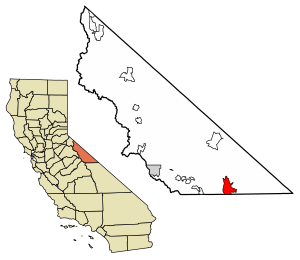
Location of Chalfant in Mono County, California.
|
|
| Country | United States |
| State | California |
| County | Mono |
| Area | |
| • Total | 28.06 sq mi (72.69 km2) |
| • Land | 28.04 sq mi (72.62 km2) |
| • Water | 0.03 sq mi (0.07 km2) 0.10% |
| Elevation | 4,258 ft (1,298 m) |
| Population
(2020)
|
|
| • Total | 660 |
| • Density | 23.54/sq mi (9.09/km2) |
| Time zone | UTC-8 (Pacific Time Zone) |
| • Summer (DST) | UTC-7 (PDT) |
| ZIP code |
93514
|
| Area code(s) | 442/760 |
| GNIS feature IDs | 1667693, 2582973 |
Chalfant (also called Chalfant Valley) is a small community in Mono County, California. It is known as a "census-designated place" (CDP). This means it's an area that the government counts for population, but it doesn't have its own official local government like a city or town.
Chalfant is located about 22 miles (35 km) south-southeast of Benton. It sits at an elevation of 4,258 feet (1,298 meters) above sea level. In 2020, about 660 people lived there.
The community is mainly a place where people live. It is located on U.S. Route 6, about 14 miles (23 km) north of the city of Bishop. Many people who live in Chalfant travel to Bishop for their jobs and to go to school.
The Chalfant post office was open from 1913 to 1928. The area's ZIP Code is 93514. Phone numbers in Chalfant use area codes 442 and 760.
The community is named after W.A. Chalfant. He moved to the area with his family in 1885. They started a newspaper called The Inyo Register. Mr. Chalfant was the editor of this newspaper for 55 years.
Earthquake in Chalfant Valley
On July 21, 1986, a strong earthquake happened near Chalfant. It had a magnitude of 6.2. This earthquake caused about $2.7 million in damage. Two people were also hurt.
Before the main earthquake, there was a smaller "foreshock." Ten days after the big quake, there was an "aftershock." Smaller aftershocks continued to happen until September 30, 1986.
Where is Chalfant?
Chalfant is located in the southeastern part of Mono County. It lies in the Chalfant Valley. This valley is at the western base of the White Mountains. The valley's water flows south into the Owens Valley in Inyo County.
The Chalfant CDP covers an area of about 28.1 square miles (72.8 square kilometers). Almost all of this area (99.90%) is land. A very small part (0.10%) is water.
People in Chalfant
| Historical population | |||
|---|---|---|---|
| Census | Pop. | %± | |
| 2010 | 651 | — | |
| 2020 | 660 | 1.4% | |
| U.S. Decennial Census | |||
The 2010 United States Census counted 651 people living in Chalfant. This means there were about 23.2 people per square mile (9.0 per square kilometer). Most of the people living there were White (91.2%). About 2.0% were Native American. People of Hispanic or Latino background made up 10.3% of the population.
All 651 people lived in homes. There were 264 households in Chalfant. About 25.8% of these households had children under 18 living in them. Most households (64.0%) were married couples.
The population was spread out by age. About 20.1% of people were under 18 years old. About 36.6% were between 45 and 64 years old. And 16.1% of the people were 65 years or older. The average age in Chalfant was 47.1 years.
There were 301 housing units in Chalfant. Most of these homes (87.5%) were owned by the people living in them. The rest (12.5%) were rented.
See also
 In Spanish: Chalfant Valley para niños


