
Chauga Mound facts for kids

Location in South Carolina
|
|
| Location | Westminster, South Carolina, Oconee County, South Carolina, |
|---|---|
| Region | Oconee County, South Carolina |
| Coordinates | 34°36′30.42″N 83°10′0.34″W / 34.6084500°N 83.1667611°W |
| History | |
| Founded | Middle Archaic |
| Abandoned | 18th century |
| Periods | Jarett Phase (1100 to 1200) Tugalo Phase (1500 to 1600) |
| Cultures | South Appalachian Mississippian culture |
| Site notes | |
| Excavation dates | 1953, 1958, 1959 |
| Archaeologists | Joseph R. Caldwell, Carl Miller, Arthur R. Kelly, Robert S. Neitzel |
| Architecture | |
| Architectural styles | platform mound, plaza |
| Architectural details | Number of temples: 1 |
The Chauga Mound was an ancient village and large dirt mound. It was located in what is now Oconee County, South Carolina. This important archaeological site was once on the bank of the Tugaloo River. Sadly, the entire site is now underwater. It was covered when Lake Hartwell was created in 1962. This happened after the Hartwell Dam was built on the Savannah River.
People lived at Chauga Mound as far back as the Middle Archaic era. But the large dirt mound and village were built much later. They were created in the 1100s by people of the South Appalachian Mississippian culture. This was a major Native American culture in the southeastern United States. The village was left empty for a while. Then, people moved back in during the 1500s.
It's possible that the historic Cherokee people lived there later. They might have occupied the site in the 1700s. The Cherokee had a village named Chauga in this area. Their homeland covered parts of what are now Virginia, North and South Carolina, Georgia, and Tennessee.
Contents
What Was Chauga Mound Like?
The Chauga Mound site included a large dirt mound and a village. It was built on a natural raised area. This spot was about 100 feet (30 meters) from the Tugaloo River. It was also about 1,200 feet (366 meters) north of where the Chauga River joins the Tugaloo.
When Was Chauga Mound Used?
Archaeologists have found four main periods when people lived at Chauga Mound:
- First Period: This was during the Middle Archaic era. Evidence shows scattered campsites from this time.
- Second Period: This includes the first six layers of the mound. It dates from 1100 to 1200 AD. This time is known as the Jarett Phase. It was part of the larger Etowah Culture.
- Third Period: The site was empty for some time. Then, people returned in the 1500s. This period includes the last four layers of the mound. It dates from 1500 to 1600 AD. This is called the Tugalo Phase, part of the Lamar Phase. The large mound suggests it was an important center for leaders during these times.
- Fourth Period: This final period was from the 1700s. It is linked to the historic Cherokee people. They are believed to have moved into this area from the north. However, archaeologists are not completely sure if this specific site was the historic Cherokee village of Chauga.
The Chauga Mound Structure

The Chauga Mound was a platform mound. This means it was a flat-topped mound, likely used for important buildings or ceremonies. Originally, it was about 12 feet (3.7 meters) tall. It was also about 115 feet (35 meters) wide at its base. The mound was built in 10 different stages or layers.
Over time, the mound was damaged by weather and people digging. Now, only the first four layers are clearly visible. The mound's height has been reduced to about 8 feet (2.4 meters).
- Stage 1: The mound started as a low, flat-topped pyramid. It was about 2.2 feet (0.7 meters) tall. It might have been used for dancing or special events. The dirt for this layer came from an older settlement. A thin layer of blue-grey clay was then added on top.
- Stages 2–6: These layers followed a similar pattern. The clay layer had a low edge and a ditch around the base. This helped protect the mound from rain. The dirt was carried to the mound in baskets. By Stage 2, the mound was 45 feet (13.7 meters) wide at the base. It had a flat top about 25 feet (7.6 meters) square. A building was placed on top of this mound. Smooth river rocks were also added to help keep the mound's shape.
- Stages 7–10: These final layers did not have the clay cap. It seems that dirt was added only to the south and east sides of the mound. This might have created a ramp or an extended area.
What Was Found at Chauga Mound?
Archaeologists found many interesting things at the Chauga village site. There were more than sixty burials in the village area. More than thirty burials were found inside the mound itself.
Many items were buried with people as grave goods. These included:
- Stone tools
- Pieces of pottery (called potsherds)
- Ornaments made from shells
- Copper plates
- Rocks and minerals
One special item found was a small plate made of steatite. It was about 1.2 inches (30 mm) long. It showed a figure that was part-human, part-animal, with a human head and wings. This style is often seen in the Southeastern Ceremonial Complex. This was a set of shared beliefs and art styles across the Southeast.
Who Explored Chauga Mound?
Several archaeologists explored Chauga Mound. Joseph R. Caldwell first dug there in 1953. Carl Miller followed in 1958.
The most detailed excavation happened from August 1958 to January 1959. This work was led by Arthur R. Kelly and Robert S. Neitzel. They worked with the U.S. National Park Service and the University of Georgia. Their goal was to save as many artifacts and as much information as possible. They knew the site would soon be flooded by Lake Hartwell after the Hartwell Dam was finished in 1962. This type of urgent digging is called salvage archaeology.
Images for kids
-
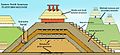
Diagram showing mound construction sequence
