Churchill River (Atlantic) facts for kids
Quick facts for kids Churchill River |
|
|---|---|

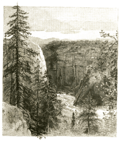
Churchill River and waterfalls, Labrador
|
|
| Native name | (Grand River, Mishtashipu) |
| Country | Canada |
| Province | Newfoundland and Labrador |
| Physical characteristics | |
| Main source | Smallwood Reservoir, Labrador 466 m (1,529 ft) |
| River mouth | Atlantic Ocean |
| Length | 856 km (532 mi) |
| Basin features | |
| Basin size | 79,800 km2 (30,800 sq mi) |
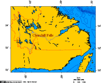
The Churchill River is a long river in Newfoundland and Labrador, Canada. It flows east from the Smallwood Reservoir all the way to the Atlantic Ocean. It passes through Lake Melville on its way.
This river is 856 km (532 mi) long. It also drains, or collects water from, a huge area of 79,800 km2 (30,800 sq mi). This makes it the longest river in Atlantic Canada.
Contents
River Names Through History
The Churchill River has had different names over time.
Original Names
The Indigenous Innu people have their own names for the river. The Labrador Innu call it Mishtashipu or Mishta-shipu. This means "Grand River." The Central Innu call it Patshishetshuanau-shipu. This means "Churchill Falls River." The Labrador Métis and Nunatsiavut people also use these names. The name "Grand River" was also used in English for a long time.
How the River Got its Current Name
In 1821, a British naval officer named Captain William Martin renamed the river. He called it the Hamilton River after Charles Hamilton. Hamilton was the governor of Newfoundland at that time.
This name was used for many years. But on February 1, 1965, the leader of Newfoundland and Labrador, Joey Smallwood, changed the name again. He renamed it the "Churchill River." This was done to honor Winston Churchill, who was a famous British prime minister. The renaming happened just before a big project to build a power plant on the river began.
River Geography

The Churchill River flows in a curved path. It starts in Ashuanipi Lake and first goes north. It then turns and flows mainly east through many lakes. Some of these lakes were flooded to create the large Smallwood Reservoir.
The river then goes through a deep, rocky canyon. This canyon is hundreds of feet deep. It flows over the famous Churchill Falls and then through many fast-moving rapids below the falls. Most of the water from the falls now flows underground. It goes through a giant power plant. The river then continues east until it reaches Lake Melville.
Hydroelectric Power Projects
The Churchill River is very important for making electricity.
Churchill Falls Power Plant
Churchill Falls is home to a huge power plant. This plant is called the Churchill Falls Generating Station. It uses almost all the water that used to flow over the natural falls. The water is sent underground to power giant turbines.
This power plant can produce 5,428 megawatts of electricity. There are plans for even more power plants on the river. These new projects could bring the total power to over 9,200 megawatts.
Sharing the Power
The Churchill Falls power plant has caused some disagreements between two Canadian provinces. Newfoundland and Labrador believes that Quebec gets too much of the profit from the power. Quebec's power company, Hydro-Québec, helped pay for the plant and provided access to the North American power grid. Hydro-Québec still buys power from the dam at prices set in an agreement from 1969.
Local Legend of a U-boat
In 2012, divers found something interesting in the river. They used special sonar equipment. They believe they found the wreck of a U-boat (a German submarine from World War II). This was found just downstream of Muskrat Falls. This finding seemed to support a local story about a U-boat in the river. However, old records do not show that a U-boat was ever there. Also, the sonar pictures were not very clear.
Images for kids
See also
 In Spanish: Río Churchill (Terranova) para niños
 | Jackie Robinson |
 | Jack Johnson |
 | Althea Gibson |
 | Arthur Ashe |
 | Muhammad Ali |


