Ciste Dhubh facts for kids
Quick facts for kids Ciste Dhubh |
|
|---|---|

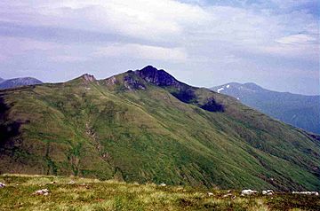
Ciste Dhubh seen from the Corbett Am Bàthach, three km to the south.
|
|
| Highest point | |
| Elevation | 979 m (3,212 ft) |
| Prominence | 388 m (1,273 ft) |
| Parent peak | Sgurr Fhuaran |
| Listing | Munro, Marilyn |
| Naming | |
| English translation | Black Chest |
| Language of name | Gaelic |
| Pronunciation | English approximation: kyisht-YƏ-goo |
| Geography | |
| Location | Kintail, Scotland |
| Parent range | Northwest Highlands |
| OS grid | NH062166 |
| Topo map | OS Landranger 33, OS Explorer 414 |
Ciste Dhubh is a mountain in the Scottish Highlands. It stands between Glen Shiel and Glen Affric. This area is quite remote. The town of Kyle of Lochalsh is about 30 kilometers (18 miles) away.
Contents
Discovering Ciste Dhubh
Ciste Dhubh is a tall mountain. It reaches a height of 979 meters (3,212 feet). In Scotland, mountains over 914 meters (3,000 feet) are called Munros. Ciste Dhubh is one of them! It is also a Marilyn, which means it stands out from the land around it.
The name Ciste Dhubh comes from Gaelic. It means "Black Chest." This might be because the rocks at the top often look dark. You can see this even on sunny days. Don't confuse it with Sgùrr na Ciste Duibhe. That's another Munro about 7 kilometers (4 miles) to the west.
Mountain Features
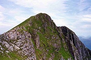
Ciste Dhubh has a sharp, pointed peak. Its sides are mostly covered in grass. But there are some rocky areas, especially on the northern slopes. The very top is rocky and steep. The ridge on the south side is also steep and narrow in places. It's generally safe for walkers. However, you need to be careful if it's windy or snowy.
The mountain also has ridges going north and northwest. These lead down to the upper part of Glen Affric. There are two small corries (bowl-shaped hollows) on either side of the northern ridge. Ciste Dhubh drops into deep valleys on most sides. But to the south, it connects to another Munro called Aonach Meadhoin. They are joined by a pass called Bealach a’ Choinich. This pass is 591 meters (1,939 feet) high. Its name means "Pass of the Bog," and it can be quite boggy! This pass is important for hikers. It also connects to the nearby Corbett called Am Bathach.
Water Flow from the Mountain
It's interesting to know where the water from Ciste Dhubh goes. All the water flows towards the east coast of Scotland. This is surprising because the mountain is only about 15 kilometers (9 miles) from Loch Duich on the west coast.
- Water from the north, east, and west sides flows into deep valleys. These valleys form the start of the River Affric. This river carries the water northeast to the Beauly Firth.
- Water from the southern slopes goes south to Loch Cluanie. From there, it flows east through the River Moriston and Loch Ness. Finally, it reaches the Moray Firth.
Climbing Ciste Dhubh
Most people start their climb of Ciste Dhubh from the A87 road. This road is just east of the Cluanie Inn, near Loch Cluanie. From there, you walk about 4 kilometers (2.5 miles) up a valley. This path leads to the Bealach a’ Choinich pass.
Another way to reach this pass is by climbing the Corbett of Am Bathach. This hill is to the east of the valley. From the Bealach a’ Choinich, it's a steep climb up grassy slopes. You then follow the southern ridge to reach Ciste Dhubh’s rocky summit. You can also climb the mountain from the youth hostel at Alltbeithe in upper Glen Affric. This route follows the northern ridge.
When you return to Loch Cluanie, you can also climb the nearby Munro of Aonach Meadhoin. This adds about 400 meters (1,312 feet) of climbing from the Bealach a’ Choinich. The view from the top of Ciste Dhubh is amazing! Even though there are higher peaks around, they aren't too close. You get great views of mountains like Mullach Fraoch-choire, A' Chràlaig, and Sgurr nan Ceathreamhnan.
 | Georgia Louise Harris Brown |
 | Julian Abele |
 | Norma Merrick Sklarek |
 | William Sidney Pittman |


