Clécy facts for kids
Quick facts for kids
Clécy
|
|
|---|---|

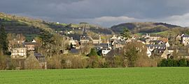
A general view of Clécy
|
|
| Country | France |
| Region | Normandy |
| Department | Calvados |
| Arrondissement | Caen |
| Canton | Le Hom |
| Intercommunality | Cingal-Suisse Normande |
| Area
1
|
24.63 km2 (9.51 sq mi) |
| Population
(2022)
|
1,301 |
| • Density | 52.822/km2 (136.81/sq mi) |
| Time zone | UTC+01:00 (CET) |
| • Summer (DST) | UTC+02:00 (CEST) |
| INSEE/Postal code |
14162 /14570
|
| Elevation | 31–261 m (102–856 ft) (avg. 80 m or 260 ft) |
| 1 French Land Register data, which excludes lakes, ponds, glaciers > 1 km2 (0.386 sq mi or 247 acres) and river estuaries. | |
Clécy is a small town, also called a commune, located in the Calvados area of the Normandy region in northwestern France. It's known for its beautiful natural scenery.
In 1932, Clécy was given a special title: The Capital of Suisse Normande. This name was given by the Tourism Minister at the time, Monsieur Gourdeau, because the area looks a lot like the mountains of Switzerland.
Contents
Exploring Clécy's Geography
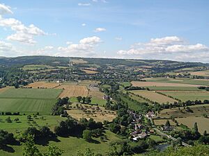
Clécy is nestled along the River Orne, right in the heart of a region called Norman Switzerland. It's about 35 kilometers (22 miles) south of the city of Caen.
This commune is quite large, covering about 24.63 square kilometers (9.5 square miles). It's the second biggest town in its local area, known as the canton of Le Hom.
Villages and Natural Features
Clécy is made up of several small villages and hamlets. These include Roche Taillis, Les Thomas, Le Clos d'Ailly, La Haute Bigne, La Faverie, Les Berthaumes, La Loterie, La Fresnée, and the main village of Clécy.
The land here is quite varied, with its highest point reaching 261 meters (856 feet) and its lowest point at 31 meters (102 feet). The area is famous for its rugged, green landscape, with valleys carved out by the Orne River. Two other streams, The Val Fournet and La Porte, also flow through the commune.
Outdoor Adventures
Because of its unique landscape, Clécy is a fantastic place for outdoor activities. You can go kayaking on the river, try paragliding from the hills, or enjoy climbing on the rocky cliffs. There are also many trails for hill walking and mountain biking.
Clécy is part of a special conservation area called the Vallée de l'Orne et ses affluents. This area covers 2,115 hectares (about 5,226 acres) and is protected under the Natura 2000 program, which helps preserve important natural habitats across Europe.
 |
Saint-Lambert | Saint-Rémy, | Le Vey |  |
| La Villette | Le Bô | |||
| Condé-en-Normandie | Pont-d'Ouilly & Saint-Denis-de-Méré | Cossesseville |
How Land is Used
A study from 2018 showed how the land in Clécy is used. Most of it, about 44%, is covered in meadows. Another 24% is used for various types of farming. Forests make up 16% of the land, and 12% is farmland where crops are grown. The remaining 3% is developed for buildings and towns.
A Look at Clécy's History
The name "Clécy" was first written down in the year 860, during the time of King Charles the Bald.
When French regions were first organized into "cantons," Clécy was actually the main town, or capital, of its canton. However, this changed after a reorganization in 1801.
Clécy has many old and interesting buildings. You can find Châteaux (castles) and manor houses scattered throughout the area. One of the oldest is the Château de la Landelle.
More recently, Clécy has been a source of inspiration for artists. Painters like Paul-Émile Pissarro, Moteley, and Andre Hardy have captured the beautiful landscapes of Clécy in their artworks.
Local Government
Clécy is run by a mayor and a local council. Here's a quick look at some of the mayors who have served the town:
| Election | Mayor | Party | |
|---|---|---|---|
| 1989 | Claude Hergault | Independent | |
| 2008 | Michel Bar | Independent | |
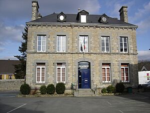
The current mayor, Raymond Carville, was elected in 2020 and will serve until 2026.
Clécy's Population Over Time
| Historical population | ||
|---|---|---|
| Year | Pop. | ±% p.a. |
| 1968 | 1,238 | — |
| 1975 | 1,187 | −0.60% |
| 1982 | 1,197 | +0.12% |
| 1990 | 1,182 | −0.16% |
| 1999 | 1,252 | +0.64% |
| 2009 | 1,238 | −0.11% |
| 2014 | 1,251 | +0.21% |
| 2020 | 1,305 | +0.71% |
| Source: INSEE | ||
The people who live in Clécy are called Clécyens in French. The population has stayed fairly steady over the years, with about 1,300 people living there in 2020.
Local Businesses
- Fromagerie Vallée: This is a local cheesemaker, producing delicious cheeses.
Places to See in Clécy
Clécy has several interesting sights to visit:
- The Château de La Landelle: This is one of the oldest buildings in the village. It was originally built in the shape of a cross and had one floor, but it was later changed to have two floors. During the Second World War, it was used by German forces.
- Musée André Hardy: A museum dedicated to the painter André Hardy.
- Musée du chemin de fer miniature: This is a museum all about miniature trains!
- Eglise St Pierre: A beautiful church from the 15th century.
- Clécy Viaduct: An impressive bridge built in 1866.
Sports and Recreation
If you enjoy golf, Clécy has an 18-hole golf course called Golf de Clecy Cantelou.
Famous People from Clécy
- Paul-Émile Pissarro (1884 – 1972): A famous French painter known for his impressionist and neo-impressionist styles. He passed away in Clécy.
Clécy's Sister Cities
Clécy has special connections with towns in other countries, known as "twin towns" or "sister cities."
 Ermington, United Kingdom (since 1980)
 Beyne-Heusay, Belgium (since 1976)
See also
 In Spanish: Clécy para niños


