Clayfield, Queensland facts for kids
Quick facts for kids ClayfieldBrisbane, Queensland |
|||||||||||||||
|---|---|---|---|---|---|---|---|---|---|---|---|---|---|---|---|

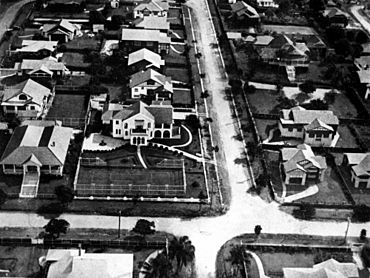
Aerial view of houses in the suburb in 1930
|
|||||||||||||||
| Population | 10,897 (2021 census) | ||||||||||||||
| • Density | 3,890/km2 (10,100/sq mi) | ||||||||||||||
| Postcode(s) | 4011 | ||||||||||||||
| Area | 2.8 km2 (1.1 sq mi) | ||||||||||||||
| Time zone | AEST (UTC+10:00) | ||||||||||||||
| Location | 7.4 km (5 mi) NE of Brisbane CBD | ||||||||||||||
| LGA(s) | City of Brisbane (Hamilton Ward) |
||||||||||||||
| State electorate(s) | Clayfield | ||||||||||||||
| Federal Division(s) | Brisbane | ||||||||||||||
|
|||||||||||||||
Clayfield is a suburb located in Brisbane, Queensland, Australia. It's a busy and well-known area. In 2021 census, about 10,897 people lived in Clayfield.
Contents
What is Clayfield Like?
Clayfield is about 7.4 kilometers (4.6 miles) northeast of the Brisbane CBD (the city center). It shares its borders with several other suburbs. To the north is Nundah, to the east are Ascot and Hendra, and to the west is Wooloowin. To the south, you'll find Albion.
Why is it Called Clayfield?
The name "Clayfield" comes from the fine, light-colored clay found and dug up in a nearby area called Albion. This clay was very important for making bricks. There used to be many brick factories in the area. This brick-making industry, known as "the clay fields," helped a lot of European settlers move into and build homes in inner-north Brisbane.
Parks and Localities
Kalinga Park is a large park on the northern edge of Clayfield. The area also includes a smaller locality called Eagle Junction.
A Look Back: Clayfield's History
Clayfield has a rich history, with many changes over the years.
Early Days and Land Sales
- In 1874, one of the first churches, a Baptist Church, opened in the area.
- In the 1880s, many large pieces of land were sold off to become smaller blocks for houses.
- For example, in 1885, the "Sefton Estate" offered 254 plots of land.
- The "Noble Estate" sold 392 plots in 1886.
- In 1888, the "Isleton Estate" was advertised, noting it was right across from the Eagle Junction Railway Station, with many trains passing by daily.
- Another sale in 1888 was "The Eagle Farm and Sandgate Estate," close to the railway line.
- In 1899, the "Albion Hill Estate" was sold, also highlighting its closeness to Albion Train Station.
Churches and Community
- A United Methodist Free Church was built around 1889 on Bonney Avenue.
- In 1901, this church became the Eagle Junction Congregational Church. A Sunday School hall was added next to it.
- The Wooloowin Methodist Church started building in 1901 but was destroyed by a cyclone. It was rebuilt and opened in 1902.
- Later, in 1975, these two churches joined together to form the Bonney Avenue Cooperative Parish.
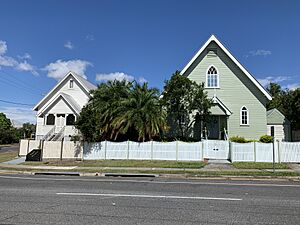
- After a larger church merger in Australia in 1977, it became Clayfield Uniting Church. The old Eagle Junction Congregational Church building was sold but still stands today.
Schools Open Their Doors
- Clayfield State School first opened its doors on 8 July 1895.
- In July 1901, its name was changed to Eagle Junction State School.
- St Agatha's Catholic Primary School welcomed its first students on 27 January 1925.
- St Rita's College, a school for girls, opened on 31 January 1926.
- Clayfield College, another well-known school, began on 9 February 1931.
Who Lives in Clayfield?
Clayfield is a diverse suburb with people from many backgrounds.
- In 2011 census, there were 10,006 people living here. Most were born in Australia (70.3%).
- Other common birthplaces included New Zealand (3.7%) and England (3.6%).
- Most people spoke only English at home (81.9%).
- By 2021 census, the population had grown to 10,897 people.
Important Historic Places
Clayfield has many buildings and sites that are important for their history. These are called heritage-listed sites. They include:
- Old homes like Casa Mara, Tresco, Mardan, and Rangemoor on Adelaide Street East.
- The railway footbridge near Alexandra Road.
- Historic schools like Eagle Junction State School, with its memorial gates.
- Several churches, including the former Congregational Church and Hall on Bonney Avenue.
- Large estates like Stanley Hall and Ralahyne on Enderley Road.
- The old Telephone Exchange on Reeve Street.
- The historic Tram Shelter and Fig Trees on Sandgate Road.
- Many beautiful old houses with unique names like "Cotswold," "Moortangi," and "Bunburra."
Education in Clayfield
Clayfield is home to several schools, offering education from primary to secondary levels.
- Eagle Junction State School is a government primary school (Prep-Year 6) for both boys and girls. In 2018, it had 877 students.
- St Agatha's Primary School is a Catholic primary school (Prep-Year 6) for boys and girls. In 2018, it had 338 students.
- St Rita's College is a Catholic secondary school (Year 7-12) for girls. In 2018, it had 1005 students.
- Clayfield College is a private school (Prep-Year 12) for boys and girls. In 2018, it had 565 students.
Local Services and Transport
Clayfield has various services and ways to get around.
Churches
You can find several churches in Clayfield:
- Clayfield Baptist Church
- Clayfield Gospel Hall
- St Agatha's Catholic Church
- St Mark's Anglican Church
- Scots Presbyterian Church
- The Clayfield Uniting Church is actually located just next door in Wooloowin.
Getting Around
- Clayfield used to have an electric tram line along Sandgate Road, which closed in 1969.
- Today, people use buses and trains from the nearby Clayfield railway station and Eagle Junction railway station.
- Along Alexandra Road, you can see beautiful poinciana and oak trees that create a lovely, leafy canopy.
Famous People From Clayfield
Some notable people have lived in Clayfield:
- Charles Evans: He was a Commissioner of Railways.
- Timothy Joseph O'Leary: A flying doctor who helped people in remote areas.
- Richard Frank Tunley: He created educational resources for children who are blind.
- Mary Hyacinthe Petronel White: She was a campaigner for women's rights and a local government councilor.
 | Victor J. Glover |
 | Yvonne Cagle |
 | Jeanette Epps |
 | Bernard A. Harris Jr. |


