Clear Fork Mohican River facts for kids
Quick facts for kids Clear Fork Mohican River |
|
|---|---|

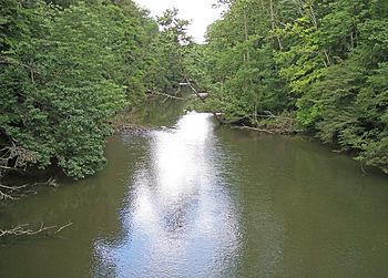
The Clear Fork in Mohican State Park in southern Ashland County, Ohio
|
|
| Country | United States |
| State | Ohio |
| Physical characteristics | |
| Main source | Morrow County, Ohio 40°46′31″N 82°38′26″W / 40.77528°N 82.64056°W |
| River mouth | near Loudonville, Ohio 40°36′30″N 82°15′14″W / 40.60833°N 82.25389°W |
| Length | 36.6 mi (58.9 km) |
| Basin features | |
| Basin size | 219 sq mi (570 km2) |
The Clear Fork is an important river in north central Ohio, United States. It is about 36.6 miles (58.9 km) long. This river is a main branch of the Mohican River.
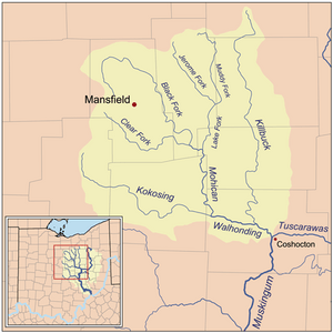
The Clear Fork is part of a much larger water system. Its water eventually flows into the Mohican River, then the Walhonding River, the Muskingum River, and finally the Ohio River. From there, it joins the mighty Mississippi River. The area of land that drains water into the Clear Fork is about 219 square miles (567 km²). Historically, people have also called it "Clear Creek" or "Clear Fork Mohecan Creek."
The River's Journey
The Clear Fork starts in the northeastern part of Morrow County, Ohio. It then flows generally towards the east. As it travels, it passes through southern Richland County, Ohio and Ashland County, Ohio.
Along its path, the river flows past several towns. These include Lexington, Ohio, Bellville, Ohio, and Butler, Ohio. It also winds its way through the beautiful Mohican State Park. The Clear Fork eventually meets another river, the Black Fork Mohican River. They join together to form the Mohican River. This meeting point is in Ashland County, about 2 miles (3.2 km) southwest of Loudonville, Ohio.
Lakes and Dams Along the River
Dams are structures built across a river to hold back water. They can create lakes or reservoirs. These can be used for things like drinking water or controlling floods.
One important dam was built in 1949 upstream from Lexington. This dam created the Clear Fork Reservoir. This reservoir is a very important source of drinking water for the city of Mansfield.
Another dam was built in Ashland County in 1936. This one was built by the United States Army Corps of Engineers. This dam created Pleasant Hill Lake. Lakes like Pleasant Hill are often used for recreation, like boating and fishing, as well as flood control.
 | Emma Amos |
 | Edward Mitchell Bannister |
 | Larry D. Alexander |
 | Ernie Barnes |


