
Cofitachequi facts for kids

Cofitachequi was a powerful Native American chiefdom. It was like a small kingdom led by a main chief. This chiefdom started around the year 1300.
European explorers first found Cofitachequi in 1540. The Spanish explorer Hernando de Soto and his group met them in what is now South Carolina. Later, other explorers like Juan Pardo and Henry Woodward also visited. Cofitachequi stopped being a political group before 1701.
Contents
Where Was Cofitachequi Located?
People have searched for Cofitachequi's exact spot for a long time. This search is linked to finding the path of Hernando de Soto. The Spanish said Cofitachequi was about 10 days' travel east from a place called Ocute. This journey was through an empty wilderness.
Cofitachequi was on a large river. It was about 100 miles from the coast. Other towns were nearby, like Talimeco. Talimeco was about 3 miles away. It sat on a high spot overlooking the river. This description suggests Cofitachequi was near the Atlantic Seaboard fall line. This is where rivers drop from hills to flat coastal lands. Another town, Ilapi, was on a second river to the east.
Cofitachequi was a big town and a special religious center. De Soto's 600 men took over half the houses there. This shows how large the town was. So, archaeologists expect to find many ruins from Cofitachequi.
First Meetings with Europeans
The Spanish might have learned about Cofitachequi as early as 1521. Two Spanish ships explored the South Carolina coast then. Near Winyah Bay (close to modern Georgetown), they captured about sixty people. These people said they were subjects of a ruler named Datha or Duhare. Datha might have been the chief of Cofitachequi. This area was about 90 miles inland from Georgetown.
One captive, named Francisco Chicora, learned Spanish. He even visited Spain. He told a writer named Peter Martyr about Datha. Chicora said Datha was "white" and tall. His people carried him on their shoulders. Datha ruled many towns with earthen mounds. These mounds were used for religious events. Chicora also said that many pearls and jewels could be found at Xapira. This was a town or chiefdom near Datha.
In 1526, these stories inspired Lucas Vázquez de Ayllón. He led 600 people to start a colony. They hoped to find the riches of Datha. At Winyah Bay, one of his ships sank. Chicora and others escaped from the Spanish. Ayllón started a settlement near Sapelo Sound in today's Georgia. But he died, and the colony was left after three months. The 150 survivors went back to the Caribbean. Ayllón's colony likely left behind European items. De Soto later found these items in Cofitachequi.
De Soto and the Lady of Cofitachequi
_(page_8_crop).jpg)
While de Soto was with the Apalachee people in Florida, he captured a boy named Perico. Perico told him about a rich land called "Yupaha." He said a woman ruled this land and it had much gold. De Soto decided to go to Yupaha. It turned out to be another name for Cofitachequi.
In the spring of 1540, de Soto and his army traveled north. They went through central Georgia. They reached the Oconee River town of Cofaqui. This town was in the chiefdom of Ocute. The people of Cofaqui knew about Cofitachequi. But they did not know its exact location. De Soto forced 700 people from Cofaqui to join him. He then went east into a large empty area. This area separated the chiefdoms of Ocute and Cofitachequi. He reached Cofitachequi after two weeks.
A woman met de Soto. The Spanish writers called her the Lady of Cofitachequi. She was carried from the town to the river on a special chair. It was covered with a fine white cloth. The Spanish saw her as the leader of the villages. She ruled over thousands of people as a "paramount chief." This means she was the main chief over many smaller chiefs.
After staying several weeks, the Spanish took the "Lady" as a prisoner. They then headed to the next chiefdom, Joara, to the northwest. She eventually escaped. The Spanish found no gold in Cofitachequi. They also found none nearby.
Later Explorers Visit Cofitachequi
Juan Pardo visited Cofitachequi (which he also called Canosi). He came with 125 Spanish soldiers. He made two trips between 1566 and 1568. Juan de Torres led 10 Spanish soldiers and 60 native allies to Cofitachequi. This happened on two trips in 1627–1628. He was "well entertained by the chief." The chief was highly respected by other chiefs. They all obeyed him.
In 1670, an Englishman named Henry Woodward traveled inland. He came from Charlestown, South Carolina. He reached Cofitachequi. He called the chief "the emperor." He said the town had 1,000 bowmen (archers). The "emperor" of Cofitachequi visited Charleston in 1670 and 1672. Sometime after that, Cofitachequi was left empty. By 1701, when John Lawson passed through, only small groups of Congaree lived there.
What Was Cofitachequi Like?
Cofitachequi was a typical Mississippian chiefdom. These were common in the American South during de Soto's time. They had a main town at the center. This town often had special mounds and temples. It controlled many smaller settlements. The main town's power reached for many miles.
These chiefdoms often had empty areas around them. These were like buffer zones between groups that sometimes fought. The people mainly grew maize (corn) for food. Cofitachequi was perhaps the easternmost of these chiefdoms. It was also one of the newer ones, starting after 1300 A.D.
Cofitachequi had different levels of leaders. The orata was a lesser noble. They seemed to be in charge of one or a few villages. The mico was a great noble. They lived in one of the chiefdom's main centers. These centers likely had mounds. Above these was the gran cacique, the great chief or paramount chief. This was the most powerful leader.
Other helpers included ynihas or ynanaes. They were like assistants to the chiefs. The yatikas were interpreters and spokesmen. The culture of Cofitachequi was similar to the Lamar culture. This culture was also found among the Ocute people in Georgia.
The people of Cofitachequi are often thought to have spoken Muskogean languages. But this is not certain. The area Cofitachequi influenced likely included people who spoke Siouan and Iroquoian languages (like the Cherokee).
Some experts believe Cofitachequi controlled towns around present-day Camden. This was an 80 to 100-mile stretch of the Wateree River. It also included parts of the Pee Dee River. Towns farther away in North Carolina and South Carolina might have paid tribute to Cofitachequi. But they still had some freedom. One expert, Charles Hudson, listed over 30 towns. These towns might have been under Cofitachequi's control. This suggests the chiefdom had tens of thousands of people.
Cofitachequi might have been losing power when de Soto visited in 1540. De Soto's army caused much damage. De Soto found little corn in the town for his soldiers. He also saw signs that a disease, possibly from Europe, had killed many people. Yet, Cofitachequi's fame lasted another 100 years. It was still known when Woodward visited.
Why Cofitachequi disappeared is not fully known. European diseases were likely a big reason. The remaining Muskogean-speaking people of Cofitachequi probably joined the Siouan people. These Siouan people lived in the area in 1701 when Lawson visited.
Images for kids
-
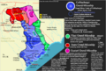
A map showing the Cofitachequi kingdom/paramountcy and its political structure in detail in the year 1538
-
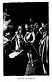
The Lady of Cofachiqui, in the book "De Soto in the land of Florida"
