Ocute facts for kids

Ocute, also known later as Altamaha or La Tama, was a powerful Native American group in the hilly Piedmont region of Georgia during the 1500s and 1600s. It was centered in the Oconee River valley. The main Ocute group was in charge of other nearby groups like Altamaha and Cofaqui.
People lived in the Oconee valley area for thousands of years. The main Ocute groups grew stronger after the Mississippian culture started around the year 1100. In 1539, the Spanish explorer Hernando de Soto and his team invaded Ocute. At that time, Ocute was in a long war with a rival group called Cofitachequi in what is now South Carolina.
Ocute remained an important power in the region into the 1600s. However, the Altamaha group became more important than Ocute. This led the Spanish to call the whole area "La Tama." In the 1660s, the group broke apart. This happened because the Westo people, who were allied with the English, attacked them and captured many people. Some towns from Ocute moved to Spanish Florida and became part of the Yamasee alliance.
Contents
What Was Ocute Like?
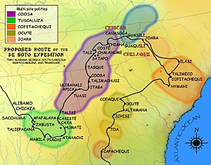
Ocute was a large "paramount chiefdom." This means it was a political group where several smaller Native American groups were controlled by one main leader. The main area of Ocute included three groups in the Oconee River valley in Georgia: Ocute, Altamaha, and Cofaqui. Each of these had a main town and special mounds (large earth hills built by people), along with smaller villages. The chief of Ocute was the most powerful leader.
Experts believe the main town of Ocute was at the Shoulderbone mound site, near Sparta, Georgia. However, later studies showed that fewer people lived there by the mid-1500s. Altamaha was located further south at the Shinholser site. Cofaqui was to the north, near Greensboro, Georgia. The people of Ocute spoke a language called Yamasee, which was similar to Hitchiti.
Another group possibly linked to Ocute was Ichisi. It was located southwest, along the Ocmulgee River at the Lamar Mounds and Village Site. Further southeast were smaller groups like Toa and Capachequi. The Guale people lived on the Georgia coast, southeast of Ocute. To the northwest of Ocute was the much larger Coosa group.
To the east of Ocute was a large empty area near the Savannah River. Spanish writers called it the "wilderness of Ocute." Beyond this wilderness were Ocute's big enemies, the Cofitachequi group in eastern South Carolina. The Savannah River area used to have many people and large groups. But it became completely empty by about 1450. This likely happened because of the fighting between Ocute and Cofitachequi. This empty area then became a protective zone against Cofitachequi.
How Ocute Began
The Oconee area first had many people around the year 150. During this time, at least three mound centers developed. People living there had similar ceramics (pottery) styles. There wasn't much evidence of corn farming back then. Later, the mound sites were left empty, and people spread out. They made simple pottery and lived in small farm homes in the Oconee valley, mostly growing corn.
Around 1100, the Mississippian culture became strong in the Oconee area. People left their old homes and moved to new settlements near the river. They used the rich soil near the river, which was great for growing corn. Pottery styles changed to "complicated stamped" pottery. People also built new mound centers. The first group in the Oconee valley started by using the old Cold Springs mound again. This group later moved to the Dyar site around 1200 and then to the Scull Shoals site around 1275.
Around 1275, a second, independent group developed at the Shinholser site, 55 miles south. This period of Mississippian culture is called the Savannah period. A third group appeared around 1325 at a new mound center, the Shoulderbone site. This site was about halfway between the other two. Experts believe this site was Ocute.
The Shoulderbone site was 8 miles east of the Oconee River, along an important path to the Savannah River. This suggests its location might have been chosen for trading or defending against people to the east. For a while, the Oconee groups traded with the Savannah Valley groups. These groups were strong in the 1300s and 1400s. But they were completely abandoned by 1450. It seems that growing conflict with the South Carolina group known as Cofitachequi was a main reason for people leaving the Savannah area. This created the "wilderness of Ocute," which acted as a protective zone against Cofitachequi.
Around 1350, farms grew quickly, and people started making more complex pottery. This marked the start of the Lamar phase of their culture. The growth of farming and the creation of the eastern protective zone might mean that all the Oconee groups were joining together into one powerful chiefdom during this time.
De Soto's Visit
By 1500, the number of people had grown a lot. There were at least five mound centers (though the Shoulderbone site had fewer people) and hundreds of smaller towns and settlements. Ocute first appeared in written history in the stories of the Spanish explorer Hernando de Soto. His team came through Ocute in 1539 on their way to Cofitachequi. They had learned about Ocute from two young men they had captured in Apalachee in Florida.
De Soto arrived at the Ichisi group on March 25, 1539. He told the local people he would be kind if their chief agreed to his rule. He visited two small towns and entered the main town of Ichisi, at the Lamar Mounds and Village Site, on March 30. The chief of Ichisi helped the Spanish fully. He told them about the powerful chief of Ocute nearby. De Soto put up a wooden cross on one of the mounds before heading to Ocute.
On April 3, the Spanish approached the Altamaha group. Their chief, Zamuno, always carried weapons in case of an attack from Cofitachequi. De Soto and Zamuno exchanged gifts. Zamuno asked if he should pay tribute directly to De Soto instead of his leader at Ocute. De Soto said their old relationship should stay the same. De Soto put up a cross and left a cannon somewhere in the area. He then called for the main chief of Ocute.
De Soto visited Ocute's main town, likely the Shoulderbone site, on April 9. He received gifts and put up another cross. His army rested for two days. On April 12, De Soto visited another group, Cofaqui. It was led by a young noble named Patofa, who ruled for his elderly uncle. Patofa showed friendship and gave the army food and people to carry their supplies.
De Soto then decided to go to Cofitachequi. The people of Ocute explained that a large wilderness separated them. They said no one alive had ever crossed it because of the war, even though De Soto's guide had claimed it was easy. Still, the army left on April 13. A group from Ocute first joined the Spanish to attack Cofitachequi. But De Soto sent them home when he realized there was no easy way through the wilderness.
La Tama and Later Years
The powerful Ocute group changed a lot in the late 1500s. A big reason was likely the Spanish founding of St. Augustine in 1565. This caused Native American groups to change their alliances because of the new Spanish power. People from Ocute moved away from the mound centers and spread out into smaller farm homes. Some even started moving into Spanish Florida. The mounds themselves were no longer used after about 1580. However, the total number of people kept growing until about 1600. During this time, Altamaha became the most important town, replacing Ocute. Spanish records from that time called the area "La Tama," which came from Altamaha.
The Spanish sent several trips to La Tama between 1597 and 1628. The first was a Franciscan mission hoping to teach Christianity. They were welcomed in Altamaha, where people seemed to accept Christianity. But at Ocute, the chief threatened to kill them if they continued, remembering De Soto's invasion. Altamaha also became unfriendly, so the mission returned to Spanish land. A military trip in 1602 found La Tama to be a rich, populated area. The chief of La Tama visited Spanish Governor Pedro de Ibarra in Guale in 1604. The Spanish thought La Tama would be a good place to settle, but they never did.
In the 1620s, the Spanish sent five military trips to look for mines and other Europeans inland. Only two reached La Tama, in 1625 and 1627. The first crossed the Wilderness of Ocute but was turned back at Cofitachequi because of the old war. The second was allowed into Cofitachequi. After this, the Spanish focused on expanding into the Timucua and Apalachee areas west of St. Augustine, rather than Georgia.
Decline and the Yamasee Alliance
Around 1630, European diseases hit the area, and the number of people started to drop quickly. In 1661 and 1662, Guale and Tama were attacked by the Westo people. The Westo were allied with the English and used flintlock muskets. They were very involved in capturing people to sell. Many La Tama people were captured, and the rest left the Oconee valley completely. Some survivors scattered to nearby Muskogean and Escamacu groups. Others fled to the Guale, Apalachee, and Timucua areas in Spanish Florida.
After this, they were among the people who became known as the Yamasee. There were about 700 to 800 Yamasee people in Florida in 1682. A mission called "Nuestra Señora de la Candelaria de Tama" was set up near San Luis, the capital of Apalachee Province, in 1675. There were 300 people at the mission in 1675, growing to 400 by 1689. But the number dropped after that as Yamasees moved closer to the English. The mission might have lasted until 1704. At that time, the remaining Yamasees moved to English territory after the destruction of the Apalachee Missions.
In the Guale and Timucuan Mocama areas, refugees from La Tama created four towns. These towns came from the old Georgia groups: Altamaha, Okatee (Ocute), Chechessee (Ichisi), and Euhaw (likely from Toa). Altamaha remained the main town. Within the Yamasee alliance, these towns formed the Lower Yamasee. Guale towns and some others formed the Upper Yamasee. The Yamasee changed alliances and later moved to what is now South Carolina in 1685. They remained an important power in the Southeast until British settlers defeated them in the Yamasee War of 1715–1717. After that, they joined other mixed groups in Spanish Florida.
 | Janet Taylor Pickett |
 | Synthia Saint James |
 | Howardena Pindell |
 | Faith Ringgold |


