Lamar Mounds and Village Site facts for kids
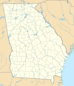
| Location | Macon, Georgia, Bibb County, Georgia, |
|---|---|
| Region | Bibb County, Georgia |
| Coordinates | 32°48′43.92″N 83°35′31.85″W / 32.8122000°N 83.5921806°W |
| History | |
| Founded | 1350 CE |
| Abandoned | 1600 CE |
| Periods | Lamar Phase |
| Cultures | South Appalachian Mississippian culture |
| Site notes | |
| Excavation dates | 1934, 1936, 1938, 1939-1940, 1996 |
| Archaeologists | James A. Ford, Arthur R. Kelly, Gordon Willey, Jesse D. Jennings, Charles Fairbanks, Mark Williams WPA, Lamar Institute |
| Architecture | |
| Architectural styles | platform mound |
| Architectural details | Number of temples: 2 |
|
Ocmulgee National Monument
|
|
| Location | 1207 Emory Hwy., E of Macon, Macon, Georgia |
| Area | 702.1 acres (284.1 ha) |
| NRHP reference No. | 66000099 |
| Added to NRHP | October 15, 1966 |
The Lamar Mounds and Village Site (also known as 9BI2) is a very important old place where people used to live. It's found next to the Ocmulgee River in Bibb County, Georgia, in the United States. It's a few miles southeast of another famous spot called the Ocmulgee Mound Site.
Both of these mound sites are part of the Ocmulgee Mounds National Historical Park. This park is a national park and historic area. It was created in 1936 and is managed by the U.S. National Park Service. Experts like historians and archaeologists think that the Lamar site was the main village of the Ichisi people. The Ichisi were met by the Hernando de Soto expedition in the year 1539.
Contents
What the Site Looks Like
The Lamar site has two big platform mounds. These are large, flat-topped hills made by people. There was also a village area next to them. This village was surrounded by a strong fence called a palisade.
The first settlement might have started on a natural raised area near the Ocmulgee River. This is where Mound A was built. The main part of the village spread out from here to the southeast. This area might have been like an island when people first settled there. It was the only high ground in a low, swampy place. The Ocmulgee River was on one side, and a curved lake (an oxbow lake) was on the other.
Village Homes and Walls
The houses in the village were shaped like rectangles. They were made using a method called wattle and daub. This means they used woven branches (wattle) covered with mud or clay (daub). Some of these houses were built on small, low mounds.
The palisade, or fence, was about 3,500 feet (1,067 meters) long. It was made of tall logs standing upright and covered in clay. This fence went around an area of about 25 acres (0.1 square kilometers). It followed the island shape of the raised land. Outside the palisade, there was a ditch that probably had water in it when the village was active.
Mounds A and B
Mound A is a large mound, about 33 feet (10 meters) across. On top of it, there's a shallow dip, about 4 to 6 inches (10 to 15 centimeters) deep. Experts believe this dip is what's left of a collapsed earth lodge. An earth lodge was a type of house with a floor dug into the ground and walls made of earth.
Unlike other Middle Mississippian culture mounds, which are often square, Lamar-style mounds are more rounded. Mound B is completely round. It has a very special feature that is rare in the southeastern United States: a spiral ramp leading up to its top. This ramp and other clues suggest that the mound was being made bigger with more earth when the work suddenly stopped.
Other Features
Unlike other Mississippian sites, there is no clear sign of a large, flat open area called a plaza at Lamar. Although, people once thought the big space between the mounds was a plaza.
Two large pits were found at the site. One was inside the palisade, and the other was outside. These pits were probably "borrow pits." This means they were dug to get earth for building the mounds. It's possible the villagers later used these pits as places to store clean water or to keep fish. This use was mentioned by people who traveled with the De Soto expedition when they passed through the area.
The Lamar Culture
People lived at the Lamar site from about 1350 CE to 1600 CE. This time period is known as the late prehistoric and early historic period in the region. The style of Mississippian culture pottery found at the site is so unique that it helped define this period. Because of this, the site is known as the type site for the Lamar culture. This period is also called the Lamar phase or Lamar period.
Digging Up the Past: Excavations
In 1936, the United States government bought the Lamar site. It became part of the new Ocmulgee National Monument. This was because of the many mounds found to the north at Ocmulgee Mounds.
The site was dug up extensively in the late 1930s. This was part of a government program during the Great Depression called the Works Progress Administration (WPA). The first digs were led by James A. Ford in 1934. Then, Arthur R. Kelly led digs in 1936. Gordon Willey worked there in 1938, and Jesse Jennings and Charles Fairbanks worked from 1939 to 1940.
To keep the site safe from floods from the Ocmulgee River, the government built a large levee (a protective wall) around it in 1941.
In 1996, archaeologist Mark Williams from the University of Georgia and the Lamar Institute did more test digs and mapped the site. These were the first archaeological explorations at Lamar since 1940.
Was This the Ichisi Village?
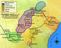
On March 29, 1539, the Hernando de Soto expedition was traveling north from Florida. They wrote about finding the area of Ichisi. This might have been part of a larger group of villages led by a powerful chief, called a paramount chief, named Ocute.
When de Soto's group arrived at the first village, they were met by women wearing white cloaks. The women offered them gifts of corn cakes and wild onions. On March 30, the Spanish explorers were taken across the Ocmulgee River in dugout canoes. There, they met the main chief of the area. They noticed he had only one good eye.
The Spanish expedition stayed at the village for several days as guests of this chief. He gave de Soto food and offered him people to carry things and translate. These helpers would assist de Soto in reaching the next chiefdom to the northeast, called Ocute. The people of Ocute were said to speak a different language than the Ichisi. Before leaving on April 1, the Spanish put up a large wooden cross on top of one of the village's platform mounds. They tried to explain what it meant to the villagers.
Debate Over Location
In the 1980s and 90s, a well-known historian and de Soto expert named Charles M. Hudson suggested something important. He thought that de Soto's group crossed the Ocmulgee River near where Macon, Georgia, is today. He also believed that the Lamar Mounds might have been the main town of the Ichisi chief. Archaeologists who have worked at the Lamar site agree with this idea.
However, new archaeological work in 2009 has raised questions. This work was done at a site in rural Telfair County, Georgia, near the town of McRae. Evidence from the Telfair site suggests that de Soto's crossing of the Ocmulgee River happened there. This location is about 90 miles (145 kilometers) further south than the Lamar Mounds. Because of this, archaeologists and historians are still discussing which of the two sites de Soto and his men actually visited.
How Lamar Got Its Name
The mounds are located on land that used to be a plantation. This plantation was owned by John Basil Lamar before the American Civil War. After he died during the war, his family kept the property. In 1936, they sold the part of the old plantation that included the mounds to the United States government.
 | William M. Jackson |
 | Juan E. Gilbert |
 | Neil deGrasse Tyson |


