Coldharbour, Tower Hamlets facts for kids

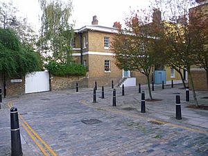
Isle House at the northern end of Coldharbour
|
|
| Location | Tower Hamlets, London |
|---|---|
| Postal code | E14 |
| Coordinates | 51°30′10″N 0°00′27″W / 51.5028°N 0.0075°W TQ383908 |
Coldharbour is a special street and a wider protected area in Blackwall, London. It sits on the north side of the River Thames, just east of Canary Wharf. People say it's the only part left of the old village of Blackwall. It's also one of the last examples of the narrow streets that used to run along the river.
Contents
History of Coldharbour
What's in a Name?
The name Coldharbour started being used in the early 1600s. People have wondered about its meaning for a long time. Some experts think a "cold harbour" was a simple shelter with just walls. Travelers would use it and bring their own beds and food, like a basic camping hut. These shelters were often found along old travel routes.
Other ideas suggest the name might come from old Roman boundary markers. These were often mounds of earth. The word could also come from old Latin or Anglo-Saxon words. These words might mean "hill with trees" or refer to "coal" or "ancient mounds." Some even think the name was a joke, named after a run-down fancy house in London. Another idea is that it was a place where goods were gathered for river transport.
How Coldharbour Grew
Coldharbour began as a path on top of a river bank in the Middle Ages. It connected Blackwall Stairs to an area near the West India Docks. The first buildings appeared in the early 1600s. This happened after the East India Company opened its shipbuilding yard in Blackwall in 1614.
Maps from the early 1700s show a line of buildings along the river at Coldharbour. These included houses, pubs, and warehouses. There were also wharves (places for ships to dock), yards, and even gardens.
A famous writer, John Betjeman, described Coldharbour as a place where "fine Georgian merchants' houses" had the river washing right up to their walls. Even though the oldest buildings still standing are from the early 1800s, many riverside spots still look much like they did in the 1600s and 1700s.
When the West India Docks opened in 1802, and the City Canal in 1805, Coldharbour became cut off. Traffic was sent to a new road called Bridge Road (now Preston's Road) in 1817. This is why Coldharbour is now a small loop road off Preston's Road. An archaeological study found signs of land being built up, probably from digging the docks.
Over time, the area between Coldharbour and Preston's Road grew. Houses were built at the north end. There were also many businesses related to ships, like shipbuilders, carpenters, and metalworkers.
Life in the Area
Someone studying poverty in London in the late 1800s wrote about Coldharbour. They noted that many people worked there but didn't live there. Those who did live there often stayed for their whole lives.
The Cold Harbour Hospital Station
In 1882, a group called the Metropolitan Asylums Board (MAB) moved its smallpox hospital ships. These ships went to a quiet part of the River Thames called Long Reach. This was about 27 km from London Bridge. To get patients to these ships, a River Ambulance Service was created. A pier was built at Long Reach in 1883 to receive patients.
The MAB bought a Cattle Wharf in Coldharbour in 1884. They wanted to build a new "North Wharf Receiving Station" there for people with infectious diseases. The local dock company was worried about sick patients being brought through the narrow streets of Coldharbour. Many of their dockmasters lived there.
To solve this, the MAB built a new road called Managers Street in 1884–85. This road connected Coldharbour to New Road (now Preston's Road). This made it easier to bring patients without disturbing the residents. At the wharf, a floating pier was built. This allowed patients to be transferred from boats at any time, no matter the tide. A metal roof was added in 1887 to protect patients from the rain while they waited for ambulances.
The Receiving Station had a room to check patients and a small ward for those too sick to travel. The pier opened in 1885. As fewer people got smallpox, the service changed. North Wharf was only for smallpox patients, while another wharf handled other fever cases. By 1921, North Wharf had 9 beds.
In 1930, the London County Council took over. By then, most patients were moved by road, not by river. The river service closed in May 1930. The buildings were torn down in 1992. In 1997, new homes were built on the land at 17 Coldharbour.
Famous People from Coldharbour

- Charles Dickens: This famous writer often visited the Fishing Smack, an old pub in Coldharbour. He wrote about the area after seeing it in 1853. The Fishing Smack pub was at 9 Coldharbour and was taken down around 1948.
- Horatio Nelson: A famous naval hero. A local story says Nelson stayed at Nelson House (3 Coldharbour). The pub called The Gun (27 Coldharbour) even claims Nelson met Emma, Lady Hamilton in an upstairs room!
- Walter Raleigh: He had a house in Blackwall, near Coldharbour. A road called Raleana Road remembers his trip to Guyana in 1595.
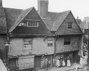
- Thomas Spert: He was in charge of the Navy for Henry VIII and the first leader of Trinity House. He lived in a large wooden house nearby when Coldharbour stretched further.
Coldharbour's Heritage
Today, Coldharbour is mostly a place where people live. The old industrial and shipping activities are gone. The Coldharbour conservation area was set up in 1975 to protect its history. It includes old buildings and structures from the former docks.
Important Buildings
Coldharbour is special because it's the only part left of the old Blackwall village. It's also one of the last examples of the narrow streets that used to line the river. With modern places like Canary Wharf and The O2 Arena nearby, this old area is even more valuable.
Several buildings in the area are "listed," meaning they are protected because of their history. Most of these are from the late 1700s and early 1800s:
- Blackwall Basin (Grade I)
- 24 Prestons Road (Grade II)
- 1 Coldharbour (Grade II)
- Isle House, at number 1, was built in 1825–1826. It was used by a dock master. It's known as the "finest house in Coldharbour." It has two floors above a basement and large curved windows. These windows gave great views of the Thames and the docks.
- 3 Coldharbour (Grade II)
- 5 Coldharbour (Grade II)
- 7 Coldharbour (Grade II)
- 15 Coldharbour (Grade II)
- 19 Coldharbour (Grade II)
- The Gun Tavern Public House, 27 Coldharbour
Important old engineering structures include the entrance to the West India Basin and the entrance to the old City Canal. This canal cut across the land and gave the "Isle" of Dogs its name. You can still visit the street, the lock entrances, and walk around the Blackwall Basin.
The Riverside View
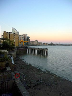
The Thames Path runs along Coldharbour. Buildings block some of the river view here. But you can get to the riverside at the old Blackwall Basin entrance and at Lockeryard Pier. From there, the path joins the Thames waterfront again.
One writer, Ian Nairn, said that this part of the river is very exciting. He noted how the curve of the river here makes sure you can see a lot of the fast-moving Thames water.
Where is Coldharbour?
Coldharbour is located in the London Borough of Tower Hamlets. It is surrounded by Landons Close to the north, Marsh Wall to the south, Preston Road and Wood Wharf to the west, and the River Thames to the east.
An editor from BBC World Service called it a "little hidden area of London by the river." He said it's very close to Canary Wharf but separated by dock basins, new buildings, and strong walls.
 |
Canary Wharf | Blackwall | East India Dock |  |
| Wood Wharf | Greenwich Peninsula | |||
| Millwall | Cubitt Town | East Greenwich |
Getting Around Coldharbour
Docklands Light Railway (DLR)
There are no DLR stations right in Coldharbour. The closest one is Blackwall DLR station in nearby Blackwall. This station is on the Docklands Light Railway and opened in 1994.
London Buses
| Route | Start | End | Served area since | Notes |
|---|---|---|---|---|
| D6 | Crossharbour ASDA | Ash Grove | 24.05.08 | |
| D7 | Mile End |
All Saints | 18.09.1999 | |
| N550 | Canning Town |
Trafalgar Square | 29.08.08 |
- Previous Bus Routes
- Route 56 (Mile End - Poplar Blackwall Tunnel) ran from 1942 to 1969.
- Route 106 (Finsbury Park - Crossharbour) ran from 1983 to 1989.
- Route 277 (Smithfield - Poplar Baths) ran from 1959 to 1989.
- Route N50 (Trafalgar Square - Gallons Reach Retail Park) ran from 1995 to 2008.
Roads
Coldharbour is connected to the main National Road Network by Prestons Road (A1206).
Education
Nearest Places
 | Leon Lynch |
 | Milton P. Webster |
 | Ferdinand Smith |


