Concord (CDP), Vermont facts for kids
Quick facts for kids
Concord, Vermont
|
|
|---|---|

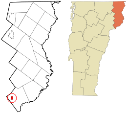
Location in Essex County and the state of Vermont.
|
|
| Country | United States |
| State | Vermont |
| County | Essex |
| Town | Concord |
| Area | |
| • Total | 1.13 sq mi (2.92 km2) |
| • Land | 1.10 sq mi (2.85 km2) |
| • Water | 0.03 sq mi (0.07 km2) |
| Elevation | 880 ft (270 m) |
| Population
(2010)
|
|
| • Total | 271 |
| • Density | 247/sq mi (95.2/km2) |
| Time zone | UTC-5 (Eastern (EST)) |
| • Summer (DST) | UTC-4 (EDT) |
| ZIP code |
05824
|
| Area code(s) | 802 |
| GNIS feature ID | 1456992 |
| FIPS code | 50-15175 |
Concord is a small community in Essex County, Vermont. It is known as a census-designated place (CDP). This means it's a specific area identified by the U.S. Census Bureau for collecting population data. Concord is the main settlement within the larger town of Concord.
In 2010, about 271 people lived in the Concord CDP. The entire town of Concord had a population of 1,235 people. For many years in the 1900s, Concord was an officially organized village. However, it stopped being an incorporated village in 1969.
Where is Concord Located?
The Concord CDP is in the western part of the town of Concord. It sits along the Moose River. This river flows west and joins the Passumpsic River. The Passumpsic River then flows into the Connecticut River. This means Concord is part of the large Connecticut River basin.
Travel and Roads in Concord
U.S. Route 2 is a major road that goes right through the middle of Concord. If you travel west on Route 2, you will reach St. Johnsbury in about 8 miles (13 km). If you head east on Route 2, you will arrive in Lancaster, New Hampshire after about 20 miles (32 km).
Concord's Size and Area
The Concord CDP covers a total area of about 2.9 square kilometers (1.1 square miles). Most of this area is land. Only a small part, about 0.07 square kilometers (0.03 square miles), is water. This water makes up about 2.5% of the CDP's total area.
See also
 In Spanish: Concord (condado de Essex) para niños
 | Selma Burke |
 | Pauline Powell Burns |
 | Frederick J. Brown |
 | Robert Blackburn |

