Congaree National Park facts for kids
Quick facts for kids Congaree National Park |
|
|---|---|
|
IUCN Category Ib (Wilderness Area)
|
|
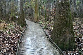
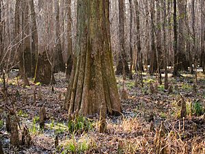
Boardwalk passes through old growth forest of bald cypress and water tupelo
|
|
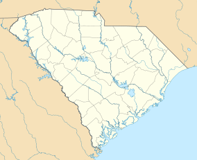
| Location | Richland County, South Carolina, United States |
| Nearest city | Eastover, South Carolina (town) |
| Area | 26,276 acres (106.34 km2) |
| Established | November 10, 2003 |
| Visitors | 145,929 (in 2018) |
| Governing body | National Park Service |
| Website | Congaree National Park |
| Designated: | 2 February 2012 |
| Reference #: | 2030 |
| Designated: | May 1974 |
Congaree National Park is a huge park in central South Carolina, USA. It covers about 26,276 acres (106 square kilometers). This special park protects the largest area of old-growth bottomland hardwood forest left in the United States.
What's a bottomland hardwood forest? It's a forest that grows in a floodplain, which is flat land next to a river that sometimes floods. The trees here are some of the tallest in the eastern United States. They form one of the highest forest canopies (the top layer of leaves and branches) in the world. The Congaree River flows right through the park. A big part of the park, about 15,000 acres, is a special wilderness area.
The park officially became a national park in 2003. This happened after many people worked hard to protect the area since 1969. In 2018, about 145,929 people visited Congaree National Park.
Contents
Park History: How it Became a Park
Early Efforts to Protect the Land
For a long time, people used the Congaree River area for logging, especially cutting down cypress trees. This started around 1898. A company owned by Francis Beidler and Benjamin F. Ferguson cut down trees until 1914. After that, the Beidler family still owned the land.
In the 1950s, a man named Harry R. E. Hampton loved this area. He worked with Peter Manigault to tell people how important it was to save the Congaree floodplain. Hampton even started a group in 1961 to protect the forest. Because of their efforts, the National Park Service studied the area in 1963 and thought it would be a good place for a national monument.
Becoming a National Monument
Not much happened for a few years. But in 1969, when logging started again, people got worried. So, in 1972, a new group called the Congaree Swamp National Preserve Association (CSNPA) was formed. They teamed up with other groups like the Sierra Club to push for federal laws to protect the land.
In 1975, South Carolina Senators Strom Thurmond and Ernest F. Hollings introduced a plan to make it a national preserve. Finally, on October 18, 1976, a law was passed. This created the Congaree Swamp National Monument. Later, in 1988, the monument was made even bigger, growing to about 22,200 acres.
From Monument to National Park
On October 24, 1988, most of the national monument became a special "wilderness area." This means it's kept as wild as possible. It also became an "Important Bird Area" in 2001, which means it's a great place for birds.
Then, on November 10, 2003, Congress changed its name to Congaree National Park. They dropped the word "swamp" because it didn't fully describe the amazing forest. They also made the park a bit larger. By 2011, the park covered about 26,021 acres.
Environment: A Special Place
Congaree National Park is a very important part of the Middle Atlantic coastal forests region. Even though people often call it a swamp, it's mostly a bottomland forest. This means it gets flooded sometimes by the river.
The park is known for its old-growth forest. This means the trees have been growing for a very long time without being cut down. It's also home to many champion trees. These are the tallest or biggest trees of their kind in the world! For example, you can find a loblolly pine that's 167 feet (51 meters) tall. There are also sweetgum, cherrybark oak, and American elm trees that are super tall. Some cypress trees in the park are more than 500 years old!
You might see many animals in the park. These include bobcats, deer, wild pigs, coyotes, and otters. The waters are full of interesting creatures too, like amphibians, turtles, snakes, and many kinds of fish. Some fish you might spot are bowfin, alligator gar, and catfish.
Things to Do and See
Congaree National Park is a special place for many reasons. It's a wilderness area, a UNESCO biosphere reserve, an important bird area, and a national natural landmark.
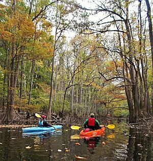
If you visit, you can go hiking on many trails. Some popular ones are the Bluff Trail (0.7 miles), Weston Lake Loop Trail (4.6 miles), and Oakridge Trail (7.5 miles). On these trails, you might see tracks from deer, raccoons, opossums, and even bobcats! You can also go canoeing or kayaking on Cedar Creek, which has a 20-mile (32 km) marked trail.
The park is a great spot for bird watching. In the summer, it's also famous for its amazing firefly displays at night. If you like camping, there are primitive campsites available.
Most visitors love walking on the Boardwalk Loop. This is an elevated walkway, about 2.4 miles (3.9 km) long, that goes through the swampy forest. It keeps you dry and protects the delicate plants and fungi on the ground. The park has the tallest and largest loblolly pines alive today.
The Harry Hampton Visitor Center is a good place to start your visit. It has exhibits that teach you about the park's nature and how people worked to protect it. Park rangers at the visitor center can tell you about current trail conditions. Sometimes, volunteers lead hikes on the longer trails, giving you a chance to explore off the boardwalk.
Climate
The climate at Congaree National Park is called a Humid subtropical climate. This means it has hot, humid summers and mild winters.
| Climate data for Harry Hampton Visitor Center, elevation 108 ft (33 m), 1981-2010 normals, extremes 1981-2019 | |||||||||||||
|---|---|---|---|---|---|---|---|---|---|---|---|---|---|
| Month | Jan | Feb | Mar | Apr | May | Jun | Jul | Aug | Sep | Oct | Nov | Dec | Year |
| Record high °F (°C) | 81.2 (27.3) |
84.1 (28.9) |
88.0 (31.1) |
91.6 (33.1) |
99.6 (37.6) |
105.3 (40.7) |
105.1 (40.6) |
104.8 (40.4) |
98.1 (36.7) |
98.5 (36.9) |
85.6 (29.8) |
81.5 (27.5) |
105.3 (40.7) |
| Mean daily maximum °F (°C) | 56.1 (13.4) |
60.1 (15.6) |
68.1 (20.1) |
75.3 (24.1) |
82.6 (28.1) |
88.9 (31.6) |
92.0 (33.3) |
90.0 (32.2) |
84.6 (29.2) |
76.0 (24.4) |
67.8 (19.9) |
58.5 (14.7) |
75.1 (23.9) |
| Mean daily minimum °F (°C) | 34.2 (1.2) |
36.8 (2.7) |
43.3 (6.3) |
50.4 (10.2) |
59.2 (15.1) |
67.1 (19.5) |
71.0 (21.7) |
70.6 (21.4) |
64.1 (17.8) |
51.9 (11.1) |
42.1 (5.6) |
35.5 (1.9) |
52.3 (11.3) |
| Record low °F (°C) | 1.2 (−17.1) |
13.2 (−10.4) |
17.6 (−8.0) |
27.5 (−2.5) |
37.5 (3.1) |
47.4 (8.6) |
56.5 (13.6) |
54.8 (12.7) |
44.7 (7.1) |
29.3 (−1.5) |
18.8 (−7.3) |
8.5 (−13.1) |
1.2 (−17.1) |
| Average precipitation inches (mm) | 3.80 (97) |
3.57 (91) |
3.96 (101) |
2.74 (70) |
3.04 (77) |
4.84 (123) |
4.91 (125) |
5.28 (134) |
3.81 (97) |
3.27 (83) |
2.85 (72) |
3.25 (83) |
45.32 (1,151) |
| Average dew point °F (°C) | 33.8 (1.0) |
36.0 (2.2) |
41.9 (5.5) |
48.3 (9.1) |
58.4 (14.7) |
66.5 (19.2) |
70.4 (21.3) |
70.6 (21.4) |
64.7 (18.2) |
53.8 (12.1) |
44.2 (6.8) |
36.6 (2.6) |
52.2 (11.2) |
| Source: PRISM | |||||||||||||
Geology: How the Land Was Formed
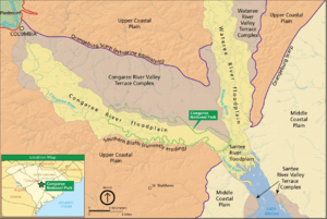
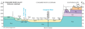
The park is located in the Congaree River Floodplain. This area is made up of sand, silt, and clay that the river has deposited over time. When plants decay, they create muck and peat. The river also creates interesting U-shaped lakes called oxbow lakes as it changes its path.
To the north of the park, there's a large crack in the Earth's crust called the Augusta Fault. To the south, there are eroding bluffs. To the west, you'll find the Fall Line, which is where the harder rocks of the Piedmont region meet the softer rocks of the coastal plain.
Documentary About the Park
In 2008, a TV station called South Carolina Educational Television (SCETV) made a documentary about Congaree National Park. It was called Roots in the River: The Story of Congaree National Park. The film included interviews with people who helped make the area a national monument. It also showed how important the park is to the local community. The documentary first aired in September 2009.
See also
 In Spanish: Parque nacional Congaree para niños


