Coosawhatchie, South Carolina facts for kids
Quick facts for kids
Coosawhatchie, South Carolina
|
|
|---|---|

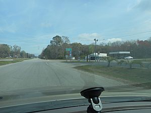
Former US 17 as it approaches the intersection with SC 462 in Coosawhatchie
|
|
| State | South Carolina |
| County | Jasper |
| Area | |
| • Total | 0.60 sq mi (1.55 km2) |
| • Land | 0.59 sq mi (1.52 km2) |
| • Water | 0.01 sq mi (0.03 km2) |
| Elevation | 203 ft (62 m) |
| Population
(2020)
|
|
| • Total | 57 |
| • Density | 97.10/sq mi (37.47/km2) |
| Time zone | UTC-5 (Eastern (EST)) |
| • Summer (DST) | UTC-4 (EDT) |
| ZIP Code |
29912
|
| Area code(s) | 843 |
| FIPS code | 45-16675 |
Coosawhatchie (koo-saw-HATCH-ee) is a small community in Jasper County, South Carolina. It's located near the start of the Broad River. In 2020, about 57 people lived here. It's easy to reach from Interstate 95.
Contents
A Look Back in Time
How Coosawhatchie Got Its Name
The name Coosawhatchie comes from the Native Americans who first lived here. They were called the Coosaw band. The word hatchie means "river" in their language. These people were part of the Muskogee group. They spoke a mix of Muskogee and Koasati languages.
Early Days and Growth
Coosawhatchie was settled by trappers in the 1740s. It was located on the King's Highway. This important road stretched from Boston all the way to Charleston. The town grew around a store owned by brothers Henry and Daniel DeSaussure. They were rice planters.
During the American Revolutionary War, British forces burned much of the town in 1779. Later, in 1788, Coosawhatchie became the main town for the Beaufort District.
A Center for Law and Decline
In 1810, a local court moved to Coosawhatchie. Seven years later, a new courthouse was built. It was designed by a British architect named William Jay. This building was used until 1840. That's when the county seat moved to a nearby town called Gillisonville. After this, Coosawhatchie became less important. People thought its marshy land was unhealthy.
Coosawhatchie in the Civil War
During the Civil War, Coosawhatchie was the site of several small battles. General Robert E. Lee made his headquarters here. This was in late 1861 and early 1862. He was working to strengthen the defenses along the coasts of South Carolina and Georgia.
To protect the railroad bridge in Coosawhatchie, Lee's soldiers dug large earthworks. These were big dirt walls along the riverbanks. They helped guard against Federal gunboats coming up the Broad River. It was also in Coosawhatchie that Lee bought his famous horse, Traveller.
Becoming Part of Jasper County
In 1912, Coosawhatchie became part of the newly formed Jasper County.
Population Information
| Historical population | |||
|---|---|---|---|
| Census | Pop. | %± | |
| 2020 | 57 | — | |
| U.S. Decennial Census 2020 |
|||
In 2020, the population of Coosawhatchie was 57 people. Most residents were Black or African American (70.18%). White people made up 10.53% of the population. About 8.77% were of mixed races. Another 10.53% identified as Hispanic or Latino.
Getting Around
Roads
- Interstate 95 (I-95) is a major highway. It runs north and south along the Eastern Seaboard. I-95 goes right through Coosawhatchie. You can get to the community from Exit 28.
- U.S. Route 17 (US 17) is another important road. It connects cities like Charleston and Savannah. US 17 shares the road with I-95 for a bit. Before the 1970s, it ran along a road now called Nuna Rock Road.
- South Carolina Highway 462 (SC 462) is known as Morgandollar Road here. It starts in Robertville and heads east. In Coosawhatchie, it crosses Nuna Rock Road. Then it goes over I-95/US 17 at Exit 28. It continues east towards Okatie.
Rail
The CSX Railway's Charleston Subdivision runs through Coosawhatchie. This line carries both cargo trains and passenger trains (like Amtrak). However, the trains do not stop in Coosawhatchie. The railway runs west of Nuna Rock Road. It crosses Morgandollar Road (SC 462). Then it goes over the Coosawhatchie River through the swampy areas.
People from Coosawhatchie
- William F. Colcock, a politician
- Mary Gordon Ellis, a politician and the first woman elected to the South Carolina legislature (she lived nearby)
- James L. Petigru, a politician and judge
 | Roy Wilkins |
 | John Lewis |
 | Linda Carol Brown |


