
Cope Butte facts for kids
Quick facts for kids Cope Butte |
|
|---|---|
.jpg)
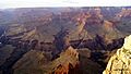
(view due-north)-Cope Butte on Granite Gorge, opposite Ninetyfour Mile Creek & Canyon, and Tower of Set
|
|
| Highest point | |
| Elevation | 4,528 ft (1,380 m) |
| Prominence | 388 ft (118 m) |
| Isolation | 2.02 |
| Parent peak | Whites Butte |
| Naming | |
| Etymology | Edward Drinker Cope |
| Geography | |

Cope Butte
Location in Arizona
|
|
| Location | Grand Canyon Coconino County, Arizona. U.S. |
| Topo map | USPS Grand Canyon |
| Geology | |
| Age of rock | Mesoproterozoic down to Proterozoic |
| Mountain type | sedimentary rock |
| Type of rock | Unknown?-prominence- (Temple Butte Formation?) Shinumo Quartzite Hakatai Shale? Bass Formation-(Bass Limestone) Vishnu Basement Rocks-(at Granite Gorge) |
Cope Butte is a cool natural landmark in the famous Grand Canyon in Arizona, USA. It's a tall, isolated hill, or "butte," that stands about 3,754-foot (1,144 m) high. You can find it right next to the mighty Colorado River, on the south side of a rocky area called Granite Gorge.
This butte is shaped a bit like a triangle. It has a long, slightly curved ridge that points towards the northwest. Cope Butte is about 4.5 miles (7.2 km) northwest of Grand Canyon Village, which is a popular spot for visitors in the central Grand Canyon. The top part of the butte is made of a white rock called Surprise Canyon Formation.
Contents
Where is Cope Butte?
Cope Butte is located deep inside the Grand Canyon National Park. It's part of Coconino County, Arizona. This butte is an important feature of the Grand Canyon's amazing landscape. It helps show how the canyon was formed over millions of years.
How Water Shapes the Land
Water plays a big role in shaping the area around Cope Butte. The west side of the butte drains into a stream called Hermit Creek. This creek flows through Hermit Canyon. The east side of Cope Butte is near the end of Monument Creek Canyon.
Because Cope Butte sits right on the edge of Granite Gorge, a famous walking path called the Tonto Trail goes around its base. This trail stretches from the northwest to the southeast.
Trails Near the Butte
Another well-known trail, the Hermit Trail, comes from the south. It starts at a viewpoint called Hermits Rest on the South Rim of the Grand Canyon. This trail goes down through red rock layers known as the Supai Group. It then continues along the southwest side of Cope Butte, leading into Lower Hermit Canyon. These trails offer amazing views of the butte and the surrounding canyon.


What is a Butte?
A butte is a type of hill with steep, often vertical, sides and a small, flat top. They are smaller than plateaus and mesas. Buttes are created when softer rock around them erodes away, leaving behind a harder core. The word "butte" comes from a French word meaning "small hill."
How Cope Butte Got Its Name
Cope Butte was named after Edward Drinker Cope. He was a famous American scientist who studied ancient life, like dinosaurs and other fossils. He was a paleontologist, which means he studied fossils to learn about life from long ago. Naming natural features after important scientists is a way to honor their contributions to knowledge.
Images for kids
-
(view due-north)-Cope Butte on Granite Gorge, opposite Ninetyfour Mile Creek & Canyon, and Tower of Set
