
Coral Way facts for kids

Coral Way is a neighborhood in Miami, Florida. It gets its name from Coral Way, a main road. This road was created in the 1920s by George E. Merrick, who also founded Coral Gables. The neighborhood is part of Miami-Dade County.
You can get to the Coral Way neighborhood using the Miami Metrorail. The Vizcaya and Coconut Grove stations serve this area.
Contents
History of Coral Way
The buildings in Coral Way show what architecture was like in the early 1900s. Some older parts have a mix of Mission Revival Style architecture and bungalow homes from the 1920s. You can also see Art Deco styles from the 1930s and simpler homes built after World War II.
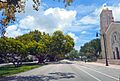
The Coral Way area is famous for its beautiful street, SW 22nd Street (Coral Way). This road is a main path between Coral Gables and the City of Miami. It runs through Miami from SW 37th Avenue to Brickell Avenue.
The Coral Way Corridor started in 1922 with streets lined with citrus trees. Later, streetcar tracks were added down the middle of the road. These tracks connected Downtown Miami to Coral Gables. In 1929, a special program began to make the roadsides prettier. As part of this, 1,200 banyan trees were planted along the middle of the boulevard. Today, Coral Way is still one of the most beautiful roads in South Florida.
Exploring Coral Way's Geography
The Coral Way neighborhood includes several smaller areas. These are Shenandoah, Silver Bluff, Vizcaya-Roads, Coral Gate, Parkdale-Lyndale, South Miami, Bryan Park, and Golden Pines.
Coral Gate: A Quiet Corner
Coral Gate is a smaller part of the Coral Way neighborhood. It is generally found south of SW 16th Street and east of SW 37th Avenue. It is also north of Coral Way and west of SW 32nd Avenue. Coral Gate is next to Coral Gables on its west side and Golden Pines to the south. Walls or barriers block cars from entering or leaving Coral Gate from its north and east sides.
Golden Pines: East of Coral Gables
Golden Pines is another small neighborhood within Coral Way. It is located east of Coral Gables. Its borders are SW 22nd Street to the north and South Dixie Highway to the south. To the east is 27th Avenue, and to the west is 37th Avenue. This area is about 10 feet (3.0 m) above sea level. 25°44′02″N 80°14′31″W / 25.734°N 80.242°W
Shenandoah: Historic Homes
Shenandoah is an important neighborhood in Miami. It has many houses built in the 1920s and 1930s. These homes show off revivalist Architecture styles. Shenandoah is just south of Little Havana. It is located between SW 9th Street (north) and Coral Way (south). Its western border is SW 27th Avenue, and its eastern border is SW 12th Avenue. This area is about 10 feet (3.0 m) above sea level. 25°45′36″N 80°13′19″W / 25.76°N 80.222°W
Silver Bluff: Annexed into Miami
Silver Bluff is a smaller area inside the Coral Way neighborhood. It is south of Coral Way (SW 22nd Street). It is west of SW 17th Avenue, east of SW 27th Avenue, and north of South Dixie Highway. Much of this land was once called the "City of Silver Bluff." It became part of the City of Miami in 1926. This area is about 10 feet (3.0 m) above sea level. 25°44′56″N 80°14′10″W / 25.749°N 80.236°W
People of Coral Way
In 2000, about 69,000 people lived in the Coral Way neighborhood. Most people living here are of Hispanic or Latino background. The zip codes for Coral Way include 33129, 33133, 33135, and 33145. The neighborhood covers about 6.697 square miles (17.35 km2).
Many people in Coral Way speak Spanish. In 2000, about 35% of the population said they did not speak English well or at all. About 19% of residents were born in Florida. Another 8% were born in other U.S. states. A large number, about 70%, were born outside the U.S.
Economy in Coral Way
The Consulate-General of Costa Rica in Miami is located in Coral Way. It is found at 2730 SW 3rd Avenue, in Suite 401.
Getting Around Coral Way
You can travel around Coral Way using the Miami Metrobus. The Miami Metrorail also serves the area at these stations:
- Vizcaya (SW 32nd Road and U.S. 1)
- Coconut Grove (SW 27th Avenue and U.S. 1)
- Douglas Road (SW 37th Avenue and U.S. 1)
Schools in Coral Way
Miami-Dade County Public Schools runs the public schools in the area.
Public Schools
Elementary Schools
- Silver Bluff Elementary School
- Frances S. Tucker Elementary School
- Coral Way K-8 Center
- Merrick Educational Center
Middle Schools
- Coral Way K-8 Center
Adult Education
- The English Center
Private Schools
- José Martí Schools
- Lincoln Martí School
- Brito Miami Private School
Parks in Coral Way
- Douglas Park
- Coral Gate Park
- Cuban Memorial Boulevard Park
- Woodlawn Park Cemetery
Images for kids
-
Coral Way with St. Sophia Orthodox Church

