
Transportation in South Florida facts for kids
The Greater Miami area, often called South Florida, includes three counties: Miami-Dade, Broward, and Palm Beach. This large area has many ways to get around, both public and private. You can find heavy trains (Metrorail), commuter trains (Tri-Rail), automated people movers (Metromover), highways, two big airports (Miami International Airport and Fort Lauderdale – Hollywood International Airport), and busy seaports (Port of Miami and Port Everglades). There are also bus networks in each county: Miami-Dade Metrobus, Broward County Transit (BCT), and Palm Tran.
Miami has the highest number of people using public transportation in Florida. About 17% of people in Miami use public transport regularly. Most public transportation in Miami is run by Miami-Dade Transit (MDT). This is the largest transit system in Florida.
South Florida is a very crowded area. It's bordered by the Atlantic Ocean on one side and the Everglades on the other. This means there isn't much space to build new things. In 2010, over 5.5 million people lived in an area of about 1,116 square miles. This makes it one of the most crowded areas in the United States. The city of Miami itself is even more crowded, especially areas like Brickell.
A big challenge for planning transportation in Miami is that people rely a lot on cars. There are many medium-sized buildings spread out, instead of being grouped together. This means it's harder for public transport to connect people to their jobs and other places easily.
Contents
How People Travel in South Florida
Transportation in South Florida mostly depends on roads and highways. Even though trains helped the area grow a long time ago, many roads were built when cars became popular.
Trains and People Movers
The Metrorail is Miami's main train system. It's about 24 miles long and only runs in Miami-Dade County. It was built after people wanted less highway expansion in the 1970s. At first, it didn't have many riders and was expensive. But over time, more people started using it.
Tri-Rail is a commuter train that connects Miami-Dade, Broward, and Palm Beach counties. It runs west of the main city areas. There are plans to add another train line, called the Coastal Link, closer to the cities, but this will take many years.
The Metromover is a free, automated train system in Greater Downtown Miami. It has about 4 miles of track. It connects to the Metrorail system. When the Metromover became free in 2002, many more people started using it. It's now a very important part of downtown life.
Roads and Tolls
Florida doesn't have a state income tax, but it has more toll roads than any other state. South Florida has many of these toll roads. Some roads also have "express lanes" where the price changes depending on how busy the road is. These tolls can get very expensive during rush hour. Even with all these road improvements, traffic is still a big problem in Miami.
Miami-Dade Transit, Broward County Transit, and Palm Tran together carry less than half a million passengers each day. This means less than 5% of the population uses public transport regularly.
Miami International Airport (MIA) is one of the busiest airports in the United States. It's especially busy with international flights. It's a huge part of Miami-Dade County's economy. In 2012, the Metrorail system connected to the airport with the AirportLink. This made it easier for people to get to and from the airport using public transport.
Traffic, train ridership, and flight numbers are usually higher in the winter season.
Highways in Miami

Miami-Dade County has many major highways. The main north-south highway is I-95. I-95 and the Palmetto Expressway are the busiest roads in South Florida. They can have over 250,000 vehicles each day. I-95 ends just south of downtown Miami.
There are three east-west highways that connect to I-95 in the Miami area: I-395, I-195, and I-595.
- I-395 goes east from I-95 to the MacArthur Causeway, which leads to South Beach. West of I-95, this road is called the Dolphin Expressway.
- A few miles north, State Road 112 (Airport Expressway) and I-195 go east over the Julia Tuttle Causeway to Miami Beach.
- In Broward County, I-595 connects I-95 to Fort Lauderdale in the east. To the west, it's known as Alligator Alley.
Many highways meet at the Golden Glades Interchange near North Miami Beach.
Several expressways in Miami-Dade County have tolls. These include the Dolphin, Airport, Don Shula, Snapper Creek, and Gratigny Parkways. They are managed by the Miami-Dade Expressway Authority (MDX). The Florida Department of Transportation (FDOT) operates most other major roads.
Toll Roads and Express Lanes

Many highways use an electronic toll system called SunPass. You can't pay with cash anymore. On the Dolphin and Airport expressways, you are charged as soon as you enter the highway.
I-95 also has express lanes that run north and south. The price for these lanes changes based on how much traffic there is. It can be very expensive during busy times. This has led to some people calling them "Lexus lanes," suggesting they are only for richer drivers.
Florida's Turnpike is a major north-south toll road. It runs from Orlando to Homestead. The Homestead Extension of Florida's Turnpike (HEFT) goes through Miami-Dade County. There are plans to add express lanes to parts of the Turnpike.
Other toll roads include the Venetian Causeway, Rickenbacker Causeway, and Broad Causeway.
The Florida Department of Transportation plans to add toll express lanes to almost every major highway in Miami-Dade and Broward counties. Many of these projects are still being built.
Other Roads

Most roads in Miami-Dade County follow a simple numbered grid pattern. Flagler Street divides north from south, and Miami Avenue divides east from west. So, streets run east-west, and avenues run north-south. Numbers increase as you move away from these dividers. Most roads have a prefix like NW, NE, SW, or SE to show their location. Some busy roads also have common names, like West 42nd Avenue, which is also called LeJeune Road.
A few areas, like Coral Gables, Hialeah, and Miami Beach, don't follow this grid. Okeechobee Road (U.S. Route 27) cuts diagonally through the urban area. U.S. Route 1, also known as South Dixie Highway, Brickell Avenue, and Biscayne Boulevard, also don't follow the grid.
Most surface roads in Broward and Palm Beach Counties also follow a grid.
Causeways
Miami has many waterways and Biscayne Bay separating the mainland from the coastal islands. This means there are many causeways and drawbridges. Three drawbridges are located close together over the Miami River in downtown Miami. The Brickell Avenue Bridge can cause long traffic delays.
| Name | Connects | Year built |
|---|---|---|
| Rickenbacker Causeway (toll) | Brickell and Key Biscayne | 1947 |
| MacArthur Causeway / I-395 | Downtown and South Beach | 1920 |
| Venetian Causeway (toll) | Downtown and South Beach | 1912–25 |
| Julia Tuttle Causeway / I-195 | Midtown and Miami Beach | 1959 |
| 79th Street Causeway | Upper East Side and North Beach | 1929 |
| Broad Causeway (toll) | North Miami and Bal Harbour | 1951 |
| William Lehman Causeway | Aventura and Sunny Isles Beach | 1983 |
Miami has six main causeways that cross Biscayne Bay. They connect the mainland to the islands along the Atlantic Ocean. The Rickenbacker Causeway is the furthest south. The Venetian and MacArthur causeways connect downtown Miami with South Beach. The Julia Tuttle Causeway connects Midtown and Miami Beach. The 79th Street Causeway connects the Upper East Side with North Beach. The Broad Causeway is the smallest and connects North Miami with Bal Harbour.
Broward and Palm Beach counties also have many causeways.
Taxis and Ride-Sharing

Taxis are very common in Miami, especially near the airport and South Beach. They usually charge a starting fee plus a fee for each part of a mile. Waiting time also costs money. A trip from the airport to South Beach can cost around $30 to $35. Toll road fees are added to this.
Companies like Uber and Lyft also operate in Miami. Zipcar offers on-demand car rentals.
Why Cars are So Important Here

The Miami area is known for how much people rely on cars. This causes a lot of traffic. People here spend almost 20% of their income on transportation.
Even though people voted for public transportation in the 1970s, the Metrorail system wasn't ready until 1984. It didn't grow as much as promised. At first, very few people used it. Some critics even joked that it would have been cheaper to buy everyone a limousine. However, ridership did increase over time.
A special tax was approved in 2002 to fund public transportation, including new Metrorail lines. But the money was used for other things. This made people lose trust in local government and public transit plans.
Because of this, Miami still relies heavily on cars. The city has a grid system with many wide roads and some toll highways. Office buildings and communities are spread out, leading to long commutes. Many buildings in downtown Miami have large parking garages, sometimes over 10 stories high.
Traffic Jams


With more people and more cars, traffic jams are common in South Florida. Highways are constantly being widened, but this often just encourages more people to drive, making traffic worse. Miami-Dade is often ranked as one of the worst places for traffic in the country. Parts of the Dolphin and Palmetto expressways, I-95, and Florida's Turnpike often have gridlock during rush hour.
Miami also often ranks high for bad drivers and accidents. This means car insurance is very expensive in Florida.
Parking
_Transit_Oriented_Planning_(6973342309).jpg)
Parking in Miami can be expensive and hard to find. Most public parking is metered or has a daily flat rate. The Miami Parking Authority manages thousands of parking spaces in the city. They issue tickets for parking violations.
Free parking at businesses is often strictly enforced. Many businesses have no free parking or only for a short time. Even in suburban areas, parking security is common. In some residential areas, people don't have private garages, so they need parking passes for their buildings, which often cost extra.
Some newer parking garages in South Florida use robots to park cars. However, some of these have had problems, even damaging cars.
Underground Parking

Unlike many big cities, underground parking is rare in South Florida. This is because the land is very low above sea level, and the ground is porous (like a sponge). The water underground is often close to sea level.
However, some newer buildings are starting to include underground parking. For example, Downtown Dadeland and Brickell City Centre have underground parking levels. Building these is much more expensive because they need special waterproof walls to keep the water out.
Air Travel
South Florida has three international airports: Miami International Airport, Fort Lauderdale–Hollywood International Airport, and Palm Beach International Airport. There are also smaller, regional airports.
Miami International Airport (MIA)

Miami International Airport is the main international airport for the Miami area. It's one of the busiest international airports in the world, serving over 40 million passengers each year. It's a major hub for American Airlines. MIA has direct flights to many cities in North and South America, Europe, Asia, and the Middle East.
The airport is connected to the Metrorail system by the MIA Mover and the AirportLink. The Miami Intermodal Center is a large center that brings together different ways to get to and from the airport, including rental cars, buses, and trains.
Airport Transportation

The MIA Mover is a free, automated train that connects the airport's main terminal to the new Miami Central Station and the Miami Intermodal Center. It's about 1.27 miles long and runs on an elevated track.
The AirportLink connects the Metrorail system to Miami Central Station. It's an elevated line that opened in 2012.
Miami Central Station is a new transportation hub. It connects the MIA Mover, Metrorail, Amtrak, Tri-Rail, Metrobus, rental cars, and personal vehicles.
Fort Lauderdale–Hollywood International Airport (FLL)
Located north of Miami in Broward County, FLL is another large airport. It's connected to the Tri-Rail system by a shuttle bus.
Palm Beach International Airport (PBI)
PBI is in West Palm Beach and mainly serves Palm Beach County. You can get to it directly from I-95 and other major roads.
Sea Travel
South Florida is located along the Atlantic Ocean. PortMiami in Miami-Dade and Port Everglades in Broward County are the two main seaports. Port of Palm Beach is a smaller port.
PortMiami

PortMiami is one of the busiest cruise ship ports in the world. It also handles a lot of cargo. It's located on an island next to downtown Miami. For a long time, you could only reach it by car or train. The train service was fixed in 2014 after being damaged by a hurricane. Also, a new $1 billion Port Miami Tunnel was completed in 2014. This tunnel connects the port directly to the highway system, helping to reduce traffic in downtown Miami.
Port Everglades

Port Everglades is in Fort Lauderdale. It's also a very busy seaport for both cruises and cargo. It hosts some of the largest cruise ships in the world.
Boating
South Florida has many marinas and waterways for boats and yachts. The Miami River goes through downtown Miami and leads to inland marinas. Fort Lauderdale is known as "Venice of America" because it has over 165 miles of inland canals. Biscayne Bay is popular for fishing, sailing, and kayaking. There are also water taxis that offer sightseeing tours.

Public Transportation

Metrorail, Metrobus, and Metromover are all run by Miami-Dade Transit. They are the main public transportation options in Miami-Dade County. Miami-Dade Transit also has a special service for people with disabilities called STS paratransit. Broward County and Palm Beach County mainly have bus systems run by Broward County Transit and Palm Tran. Tri-Rail is a train system that connects all three counties. There are also local bus systems and trolley networks in smaller cities.
South Florida's long and spread-out shape makes it hard to design public transit systems that serve everyone. Miami is also a relatively new city that grew mostly when cars were popular. This means it's very car-focused. About 17% of people in the city of Miami use public transportation regularly.
The University of Miami is the only major university with a direct train station (University Station).
A survey in 2014 found that people in Miami-Dade County cared most about trains and buses being on time.
From 2010 to 2015, Metrorail ridership grew a lot. However, Metrobus ridership went down when gas prices were low.
Miami-Dade Transit (MDT)
_system_map.svg)

Miami-Dade Transit runs most of the public transport in Miami-Dade County. This includes Metrorail, Metromover, Metrobus, and STS paratransit.
Metrorail

Metrorail is Florida's only heavy train system. It has two lines. The original Green Line is about 22.4 miles long with 22 stations. It started in 1984. There were plans for many more lines, but only the 2.4-mile AirportLink was built. This line opened in 2012 and connects to Miami International Airport.
A standard fare for Metrorail and Metrobus is $2.25. Since 2009, you need an EASY Card or EASY Ticket to enter stations.
Metrorail runs from 5 a.m. until midnight every day. During busy weekday hours, trains arrive every five minutes. On weekends, they come every 15 minutes. Many stations have parking lots or garages, which cost $4.50.
New Metrorail cars are being built in Miami-Dade County. They are expected to be ready by 2018.
Metromover
Metromover is a free, automated train system. It runs on three loops in downtown Miami. It has about 4.4 miles of elevated track and 21 stations. The main loop opened in 1986, and extensions opened in 1994.
The Metromover became very popular when it became free to ride in 2002. Ridership has doubled since then. It's used by people who live, work, or visit downtown. It's also used by people who come into the city using Metrorail and Tri-Rail. Metrorail and Metromover connect at the Government Center and Brickell stations. Trains arrive every two to five minutes.
Metromover Stations
The Metromover has 21 stations. Combined with Metrorail, the whole system has 45 stations. Metromover stations are about two blocks apart in downtown Miami. Metrorail stations are about a mile apart.
Some new buildings are being built with direct connections to Metromover stations, like Brickell City Centre. This makes it easier for people to live and work near public transport. There are also ideas to extend the Metromover to the Port of Miami and South Beach.
Metrobus
The Metrobus network provides bus service throughout Miami-Dade County every day of the year. It has over 100 routes and about 817 buses. It connects most places in the county and even parts of southern Broward County. The standard fare is $2.25. Some routes run 24 hours a day. All Metrobuses are wheelchair accessible.
South Miami-Dade Busway

The South Miami-Dade Busway is a special bus system that started in 1997. It has 28 stops that look like train stations. A walking and biking path, called the South Dade Rail Trail, runs alongside the Busway.
Broward County Transit (BCT)
Broward County Transit (BCT) runs the bus system in Broward County. It's the second largest transit system in Florida. It also serves parts of Palm Beach County and Miami-Dade County.
Palm Tran
Palm Tran is the bus system for Palm Beach County. A standard one-way fare is $1.50. You can also buy daily or monthly passes. All Palm Tran buses have bike racks on the front.
Other Buses and Trolleys

South Beach has its own local bus system called the South Beach Local, which costs only 25 cents. Many cities in Miami-Dade and Broward counties have trolley-replica buses. These are often free. For example, the Coral Gables Trolley has been very successful since 2003, moving many commuters. Miami started its own trolley system in 2012, with routes around downtown and to places like Marlins Park.
Universities like the University of Miami and Florida International University also have free shuttle bus services for their students.
Walkability
A 2011 study ranked the city of Miami as the eighth most walkable large city in the United States. This ranking looks at how close restaurants, food stores, transit stops, and entertainment are. However, some people say this ranking doesn't fully consider safety for pedestrians.
Transit-Oriented Development (TOD)
Recently, there's been more focus on building homes and businesses near public transportation lines. This is called transit-oriented development. For example, new affordable housing projects have been built near Metrorail stations like Brownsville and Santa Clara.
Historically, some buildings were built with connections to the Metromover and Metrorail systems in the 1980s. The Knight Center Metromover station is built into the Miami Tower. The Omni International Mall was connected to the Adrienne Arsht Center station by a bridge. The area around the Dadeland North and Dadeland South Metrorail stations has also grown a lot, becoming a busy area with many businesses and homes.
Downtown Miami and Brickell have also become very dense, with many tall buildings near Metromover lines. This has helped Metromover ridership double. However, many of these new buildings are expensive and don't always focus on affordable housing.
Metromover and Development

During the building boom of the 2000s, many new condo buildings were built in downtown Miami. This, along with the Metromover becoming free, led to a big increase in ridership. Large projects like Brickell City Centre and Miami Worldcenter are now including Metromover stations directly into their designs.
Some buildings, like The Loft 2 and Centro Lofts, were allowed to have less parking because they are so close to public transport. Downtown and Brickell are sometimes compared to New York City because of their tall buildings and access to transit.
Future Plans for Transportation

Many transportation projects have been planned for Miami-Dade County, but some have been canceled due to money problems. In the 1970s, people voted to fund public transit instead of building more highways. Building new heavy train lines can be very expensive.
MDT Orange Line (Metrorail)

The Orange Line was a big plan for three new Metrorail lines. Only one part was built: the short connection to Miami International Airport from the Earlington Heights station. This part, called the AirportLink, opened in 2012. The other two planned lines were canceled, partly because of how the tax money was used.
Even though only a small part was built, the entire line from the airport to Dadeland South is now called the Orange Line.
Coastal Link (Tri-Rail)
The "Coastal Link" is a long-proposed project to move or expand Tri-Rail service to a different train line closer to the cities. This would bring the train closer to more people and into Downtown Miami. It could also extend north to Jupiter. This project would require big upgrades to the train line and new stations.
Plans for this "Coastal Link" came up again with the building of All Aboard Florida's new train system. This project would require building new stations and possibly a third track.
BayLink
BayLink is a long-proposed plan for a streetcar, light rail, or Metrorail extension that would connect Downtown Miami to South Beach. Miami Beach officials have preferred a less intrusive option like a streetcar. This project is still being considered.
SMART Plan (2016)
In 2016, a new plan called the Strategic Miami Area Rapid Transit (SMART) was introduced. It identified six areas that need better public transit. These lines could use different types of transit, like bus-rapid transit or light rail. The total cost for these projects would be very high.
Downtown Streetcars
There have been proposals for new streetcar lines in downtown Miami. Miami used to have an extensive streetcar system in the 1920s. Some lines were very fast. However, hurricanes and other factors led to the streetcar system closing by 1940, replaced by buses.
Fort Lauderdale also had plans for a downtown streetcar system called The Wave. This project has faced delays.
Transit to PortMiami

A study was proposed in 2011 to see if a Metromover extension to PortMiami was possible. This would connect the airport to the seaport using public transit, though it would require multiple transfers. This idea is still being considered.
The train track to PortMiami was fixed in the early 2010s for freight service. New train projects could also bring passenger train service to the port in the future.
Geography and Environment


South Florida's urban area is limited by the Atlantic Ocean to the east and the protected Everglades wetlands to the west. Miami-Dade County has a special boundary called the Urban Development Boundary (UDB). This boundary is changed carefully to allow new development, but it usually focuses on low-density housing. This is different from downtown Miami, where very tall buildings are allowed.
Hurricanes are a big threat to Miami's buildings and roads. Miami is considered one of the most at-risk cities for financial loss due to storms and climate change. Miami is also very vulnerable to sea level rise. Miami Beach already experiences annual tidal flooding (flooding from high tides).
Dealing with Sea Level Rise


Some areas of South Florida, especially Miami Beach, are starting to build things specifically to deal with sea level rise. This includes installing pumps, building taller sea walls, and raising the level of roads. Miami Beach sees sunny day flooding during very high tides, called "king tides." Some streets and sidewalks have been raised by about 2.5 feet.
Traditional ways to fight sea level rise, like sea walls, might not work well in South Florida. This is because the ground is porous limestone, so water can seep through it. More than half of South Florida is less than 6 feet above sea level.
History of Transportation

Even though Miami is a relatively young city that grew with cars, it had an extensive early transit system in the 1920s. The first electric streetcar operated around 1906. A more widespread electric streetcar system started in 1922. It even had a high-speed line from Miami to Coral Gables. However, hurricanes and other factors led to the streetcar system closing by 1940, replaced by buses.
Henry Flagler's Florida East Coast Railway passenger service reached Miami in 1896, the same year the city was founded.
The modern Miami-Dade Transit agency was created in 1960. Studies for a mass transit system in Miami-Dade County began in 1964. In 1969, a 67-mile train system was proposed. It aimed to connect Miami Beach to Miami International Airport through downtown. While the AirportLink finally connected the airport in 2012, a direct link to Miami Beach is still missing.
Images for kids
-
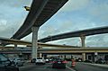
The Dolphin—Palmetto Interchange being built in early 2015.
-
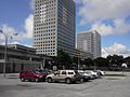
The headquarters of Miami-Dade Transit next to the Historic Overtown-Lyric Theater Metrorail station.
-
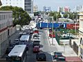
Traffic in Downtown Miami caused by trucks leaving the port. The Port Miami Tunnel helped with this.
-

The Loft 2 condominium, built around the First Street Metromover station, has no parking on site.
-
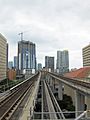
Metrorail tracks running over Metromover tracks at Government Center.
-
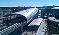
The new Miami Central Station being built in December 2011.
-

Critical Mass Miami gathering in Government Center.
-
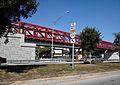
The MetroPath bridge over the Snapper Creek Expressway entrance, finished in January 2012.
-
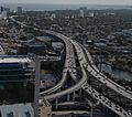
The southernmost part of Interstate 95 near Downtown Miami is often very busy.
-
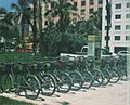
A DecoBike BikeShare rack in South Beach.
-
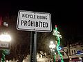
A sign on Hollywood Boulevard in 2011.
-

The unused east-west platform at Government Center station, built in 1984 but never completed.
-
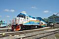
A Tri-Rail train and experimental coach in the CSX Hialeah Yard.
-
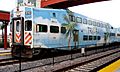
A Tri-Rail passenger car.


