Corn Springs facts for kids
Quick facts for kids |
|
|
Corn Springs
|
|

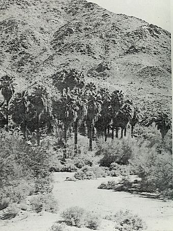
Washingtonia filifera trees at Corn Springs
|
|
| Nearest city | Desert Center, California |
|---|---|
| NRHP reference No. | 98001286 |
| Added to NRHP | October 30, 1998 |
Corn Springs is a special place in the Chuckwalla Mountains of the Colorado Desert in Riverside County, California. It's an oasis with many palm trees, located about seventeen miles southeast of Desert Center, California.
Long ago, Native Americans depended on the water from these springs. They carved many pictures, called petroglyphs, into the rocks nearby. Later, in the late 1800s, miners also used the springs. They even created the Corn Springs Mining District in 1897.
In 1998, Corn Springs was added to the United States National Register of Historic Places. This means it's an important historical site.
Contents
A Look Back: History of Corn Springs
Corn Springs has been used for thousands of years by different Native American groups. These groups, like the Chemehuevi, Desert Cahuilla, and Yuma, often visited the spring.
They left behind amazing petroglyphs carved into the rocks. Some of these rock carvings are over 10,000 years old! Sometimes, there was enough water for them to grow some plants. The Native Americans also used the fruit from the palm trees.
How Corn Springs Got Its Name
When early European visitors came to the area, they found wild corn plants growing near the spring. This is how the spring got its name, "Corn Springs."
Miners and Gus Lederer
In the late 1800s, miners arrived in the area. They used the spring's water to help them find gold. A well-known person who lived at the spring was Gus Lederer. He called himself the "Mayor of Corn Springs."
Gus Lederer lived there until 1932, when he passed away. After his death, the land became public property. The Bureau of Land Management (BLM) then set up a campground there.

Today, the BLM runs a campground at Corn Springs. There's a well where visitors can get water from the spring. A little further past the campground, you can find an old miner's cabin and what's left of a mill. A family named Wodetzki mined in this area until the early 1980s. They had claims for gold, silver, and iron ore. More old mines and cabins are located further up the road.
Nature and Location
Corn Springs is located at coordinates 33°37′34″N 115°19′31″W / 33.62611°N 115.32528°W. Over 60 California Fan Palm trees grow around the spring. Usually, you won't see water flowing on the surface. However, the stream bed that drains the area is called Corn Springs Wash.
The amount of water at the spring changes a lot over time. Scientists don't fully know where the water comes from. Not much rain falls in this desert area. The closest large body of water is the Colorado River, which is over 40 miles away to the east.
You can reach Corn Springs by taking Corn Springs Road. This road connects to Chuckawalla Valley Road, which is just off Interstate 10. It's about halfway between the towns of Indio and Blythe.

