
Coronel Fabriciano facts for kids
Quick facts for kids
Coronel Fabriciano
|
|||
|---|---|---|---|
|
Municipality
|
|||
| The Municipality of Coronel Fabriciano | |||

Partial view of Coronel Fabriciano seen from Timóteo
|
|||
|
|||
| Nicknames:
"Fabri" "Fabriciano" "Terra mãe do Vale do Aço" |
|||
| Motto(s):
Deus, Pax Et Prosperitas, Deus, Paz e Prosperidade God, Peace and Prosperity |
|||
 |
|||

Coronel Fabriciano
Location in Brazil
|
|||
| Country | |||
| Region | Southeast | ||
| State | Minas Gerais | ||
| Founded | January 20, 1949 | ||
| Area | |||
| • Total | 221.252 km2 (85.426 sq mi) | ||
| Elevation | 250 m (820 ft) | ||
| Population
(2020)
|
|||
| • Total | 110,290 | ||
| • Density | 498.5/km2 (1,291/sq mi) | ||
| IBGE | |||
| Demonym(s) | Fabricianense | ||
| Time zone | UTC-3 (UTC-3) | ||
| Postal Code |
35170-000
|
||
| HDI (2010) | 0.755 – high | ||


Coronel Fabriciano is a city in the state of Minas Gerais, Brazil. It is located in the Southeast part of the country. The city is about 200 km (124 miles) from Belo Horizonte, the state capital.
In 2020, about 110,290 people lived here. The city covers an area of about 221 square kilometers (85 square miles).
Coronel Fabriciano became its own city in 1948. It was named after Lieutenant colonel Fabriciano Felisberto Carvalho de Brito. The city is part of the Vale do Aço (Steel Valley) area. This area is known for its large steel industries. These industries helped the city grow a lot.
The city is also home to many natural spots in the Serra dos Cocais mountains. You can find cool places like "Pedra Dois Irmãos" (Two Brothers Stone) and "Cachoeira do Escorregador" (Slide Waterfalls). People enjoy outdoor sports here, such as hiking, mountain biking, and even parachute jumping!
Coronel Fabriciano also has important historical buildings. These include the "Catedral de São Sebastião" (Saint Sebastian Cathedral) and the "Colégio Angélica" (Angélica College). The city's Human Development Index (HDI) is 0.755, which is considered high.
Contents
History

The area where Coronel Fabriciano is now was once a forest. Its first name was Barra. Later, it was called Calado, then Raul Soares, and then Calado again.
In 1926, the area became a district. The first houses were built after the Calado Train Station opened. In 1928, the first proper house with a ceramic roof was built.
In August 1938, the district was named Coronel Fabriciano. This was to honor Colonel Fabriciano Felisberto de Brito. Ten years later, it officially became a municipality.
On December 27, 1948, Coronel Fabriciano became a city. The first mayor, Dr. Rubem Siqueira Maia, took office on March 15, 1949. Even though the city was created in December, its birthday is celebrated on January 20. This is the day of the city's patron saint, São Sebastião.
Geography


Quick Facts
- Elevation: 240 meters (787 feet)
- Climate: Sub-tropical
- Average yearly temperature: 22 °C (72 °F)
- Latitude: 19°31'07" South
- Longitude: 42°37'44" West
Main Streets and Avenues
Many streets in Coronel Fabriciano are named after important people. Some of the main ones include:
- Avenida Julita Pires Bretas
- Avenida José de Magalhães Pinto
- Avenida Geraldo Inácio
- Avenida Tancredo de Almeida Neves
- Rua Pedro Nolasco
Districts
- Senador Melo Viana
- Coronel Fabriciano (the main city area)
Distances to Other Cities
Here are some distances from Coronel Fabriciano to other major cities:
- Belo Horizonte: 198 km (123 miles)
- Rio de Janeiro: 560 km (348 miles)
- São Paulo: 765 km (475 miles)
- Vitória: 420 km (261 miles)
- Ipatinga: 13 km (8 miles)
- Timóteo: 6 km (4 miles)
Economy

Coronel Fabriciano is located between Ipatinga and Timóteo. These cities have some of the biggest steel industries in Minas Gerais. Coronel Fabriciano is the second largest city in this "Steel Valley" area.
The main activities in Coronel Fabriciano are:
- Trading (buying and selling goods)
- Services (like hotels and shops)
- Growing eucalyptus trees
- Small and medium-sized factories
Commerce and Services
The city has many shops and businesses. There are over 3,500 registered shops. There are also more than 3,200 service businesses. This includes many hotels, with about 1,800 rooms available for visitors.
Agriculture
Eucalyptus trees are grown in the countryside around the city. These trees are used to make cellulose for paper. They are also used to make charcoal.
Industry
Many factories are located in Coronel Fabriciano. Some of them are in the city's Industrial District.
Sports

Extreme Sports
The Serra dos Cocais mountains are great for extreme sports. People enjoy riding motorcycles and bikes on the trails. You can also take calm walks or horse rides to see the beautiful waterfalls.
Auto Racing
The city has a Jeep Club called Jipe Clube Vale do Aço. They often organize jeep trips and competitions. In 2008, Coronel Fabriciano hosted a big 4x4 Regularity rally race.
Football
The city's main professional football team is Social. They play in the state's top league, the Campeonato Mineiro.
Climate
| Climate data for Coronel Fabriciano (1981–2010) | |||||||||||||
|---|---|---|---|---|---|---|---|---|---|---|---|---|---|
| Month | Jan | Feb | Mar | Apr | May | Jun | Jul | Aug | Sep | Oct | Nov | Dec | Year |
| Mean daily maximum °C (°F) | 32.3 (90.1) |
33.0 (91.4) |
32.3 (90.1) |
31.0 (87.8) |
29.0 (84.2) |
27.9 (82.2) |
28.1 (82.6) |
28.6 (83.5) |
29.6 (85.3) |
30.1 (86.2) |
30.9 (87.6) |
31.2 (88.2) |
30.3 (86.5) |
| Daily mean °C (°F) | 25.3 (77.5) |
25.5 (77.9) |
25.0 (77.0) |
23.5 (74.3) |
21.4 (70.5) |
19.5 (67.1) |
19.1 (66.4) |
19.9 (67.8) |
22.0 (71.6) |
23.3 (73.9) |
24.2 (75.6) |
24.7 (76.5) |
22.8 (73.0) |
| Mean daily minimum °C (°F) | 20.6 (69.1) |
20.5 (68.9) |
20.1 (68.2) |
18.5 (65.3) |
16.2 (61.2) |
14.1 (57.4) |
13.1 (55.6) |
13.9 (57.0) |
16.4 (61.5) |
18.6 (65.5) |
19.4 (66.9) |
20.2 (68.4) |
17.6 (63.7) |
| Average precipitation mm (inches) | 239.8 (9.44) |
137.1 (5.40) |
162.5 (6.40) |
66.6 (2.62) |
40.6 (1.60) |
15.2 (0.60) |
7.4 (0.29) |
18.1 (0.71) |
48.7 (1.92) |
108.0 (4.25) |
258.1 (10.16) |
312.8 (12.31) |
1,414.9 (55.70) |
| Average precipitation days (≥ 1.0 mm) | 13 | 8 | 10 | 6 | 5 | 3 | 2 | 2 | 5 | 8 | 14 | 16 | 92 |
| Average relative humidity (%) | 80.0 | 77.8 | 79.8 | 81.1 | 82.2 | 82.4 | 79.2 | 76.3 | 74.5 | 75.5 | 79.9 | 81.3 | 79.2 |
| Source: Instituto Nacional de Meteorologia | |||||||||||||
Images for kids
-

City Hall
-
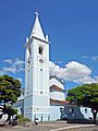
Saint Sebastian Parish Church (1949)
-
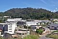
Industrial District
-
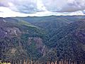
Hills of the Serra dos Cocais


See also
 In Spanish: Coronel Fabriciano para niños
