County of Stettler No facts for kids
Quick facts for kids
County of Stettler No. 6
|
|
|---|---|
|
Municipal district
|
|

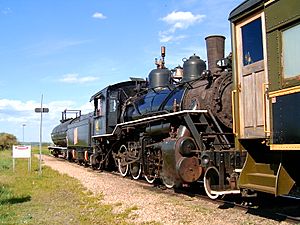
Alberta Prairie Railway, engine 41
|
|
| Country | |
| Province | |
| Region | Central Alberta |
| Census division | No. 7 |
| Established | 1943 |
| Incorporated | 1955 (County) |
| Area
(2016)
|
|
| • Land | 4,018.84 km2 (1,551.68 sq mi) |
| Population
(2016)
|
|
| • Total | 5,322 |
| • Density | 1.3/km2 (3/sq mi) |
| Time zone | UTC-7 (MST) |
The County of Stettler No. 6 is a special kind of local government area, like a big rural county, located in the middle of Alberta, Canada. It's a place where many people live and work, often on farms or in small towns.
Contents
Who Lives Here?
In 2016, about 5,322 people lived in the County of Stettler No. 6. These people lived in about 1,850 homes. This number was a little bit higher than in 2011.
The county is quite large, covering about 4,018 square kilometers (about 1,551 square miles). This means that, on average, there were only about 1.3 people living in each square kilometer. This shows it's a very spread-out area, not crowded like a big city!
Towns and Communities
The County of Stettler No. 6 surrounds several towns and villages. It also contains many smaller communities called hamlets and localities.
Urban Areas
These are places with more people living closer together, like towns and villages.
Towns
Villages
Summer Villages
These are small communities, often near lakes, where people might live mostly in the summer.
Rural Communities
These are smaller places, often with fewer people, located in the countryside.
Hamlets
Localities
These are even smaller places, sometimes just a few houses or a specific area.
- Anderson Addition
- Bolin Subdivision
- Caprona
- Fenn
- Gopher Head
- Hackett
- Hartshorn
- Heart Lake
- Leahurst
- Leo
- Nevis Junction
- Oberlin
- Repp Addition
- Repp Subdivision
- Sabine
- Scollard
- Warden
- Warden Junction
- Willowglen Estates
Other Places
- Cordel


