
Cove Lake State Park facts for kids
Quick facts for kids Cove Lake State Park |
|
|---|---|

Cove Lake
|
|
| Type | Tennessee State Park |
| Location | Caryville, Campbell County, Tennessee |
| Area | 673 acres (2.72 km2) |
| Created | 1937 |
| Operated by | Tennessee Department of Environment and Conservation |
| Website | Cove Lake State Park |
Cove Lake State Park is a beautiful state park located in Campbell County, Tennessee. It covers about 673 acres (2.7 km²) of land. The park is built around Cove Lake, which was formed when the Caryville Dam was finished in 1936. You can find the park right next to the town of Caryville.
Cove Lake is actually connected to a much larger body of water called Norris Reservoir. This park was one of several parks created in the 1930s as part of the big Norris Dam Project. Today, Cove Lake State Park offers a large campground for visitors. It also has several short walking trails and a special area to watch wildlife. A part of the Cumberland Trail even runs close to the park's northern edge. This trail connects the park to nearby mountains.
Contents
Exploring the Park's Location

Cove Lake State Park is found at the western end of Powell Valley. This valley is about 50 miles (80 km) long. It separates the Cumberland Mountains to the north and west from the Appalachian Ridge-and-Valley range to the south and east. When you look west, you'll see Cross Mountain. It's the tallest mountain in Tennessee west of the Blue Ridge Mountains, standing at 3,534 feet (1,077 m).
Just north of the park, you can see the southern tip of Fork Mountain. A long, narrow ridge called Cumberland Mountain stretches for almost 40 miles (64 km). Its rocky western tip is called Devil's Racetrack. You can see it from almost anywhere in the park.
Cove Creek starts in the mountains to the northwest. It flows southeast for about 25 miles (40 km). Then it empties into the Clinch River. The Caryville Dam was built across this creek. The lake created by the dam stretches for about 2 miles (3.2 km) upstream. It also covers a 1-mile (1.6 km) stretch of Dog Creek. This forms a U-shape around the park. The whole lake covers about 210 acres (0.85 km²).
Interstate 75 runs along the western side of the park. This highway connects the area to Kentucky in the north and Knoxville in the south. U.S. Route 25W goes through the southern and eastern parts of the park. It links the park with Caryville to the west and the Norris Dam area to the east.
A Look Back in Time
Early Days of the Area

In the 1930s, scientists dug up old sites near where US-25W now crosses Cove Lake. They found proof of a Mississippian period village. This was a Native American village that existed between 1000 and 1500 AD. The site is known as the Irvin Mound Site. It had a large mound and a village that covered almost 15 acres (6.1 ha).
Researchers found that the houses were made of small logs. These logs were stuck into the ground and tied together with cane and grass. They also found human burials, pieces of pottery, and tools. These tools and weapons were made from stone, animal antlers, and bone.
The first European-American settlers came to Powell Valley in the early 1800s. A community called Wheelerville started as a train stop in 1867. By 1880, its name changed to "Caryville." Most early settlers were subsistence farmers. This means they grew just enough food for themselves and their families. Later, large logging companies moved into the area. In the 1890s, coal mining began near Cross Mountain. The Stone Mill, built around 1900, was a community hub. It was bought in 1934 as part of the Norris Project.
The Norris Project and the Park's Creation

In the 1920s, many groups wanted a dam built on the Clinch River. This dam would help control floods and provide electricity. The project was first called the "Cove Creek Project." But in 1933, the Tennessee Valley Authority (TVA) took over. It became known as the "Norris Project." The project was named after Senator George Norris, who helped create the TVA. Building Norris Dam started in 1934. Its gates closed in 1936, creating the Norris Reservoir.
The TVA built Caryville Dam to protect Caryville from the new Norris Reservoir. Even so, some buildings in the town had to be moved or torn down. Two highways also had to be rerouted. Cove Lake State Park was planned by the TVA as one of three special recreation areas. The other two were Norris Dam State Park and Big Ridge State Park.
The Civilian Conservation Corps (CCC) started working on Cove Lake State Park in 1937. The CCC was a program during the Great Depression that put young men to work. They built the park office, a restaurant, stone cabins, a boat dock, and park roads. The park office and part of the restaurant are still standing today. In 1950, the park was given to the state of Tennessee. Since then, more modern facilities have been added.
Cove Lake State Park Today

Cove Lake State Park has a campground with 106 sites. It also has an indoor building for events, a restaurant, and several sports fields and courts. There are many small walking trails throughout the park. One paved trail is 3.5 miles (5.6 km) long and follows the lakeshore. Another trail leads to Wheeler Cemetery and Caryville Dam. The park also has a wildlife observation area. It's in the northwest part of the park and includes a 15-foot (4.6 m) observation tower.
The Cumberland Trail is a long hiking trail that will eventually connect Cumberland Gap to Prentice Cooper State Forest. A section of this trail, called the Cumberland Mountain Segment, will go along the top of Cumberland Mountain. It will connect Cumberland Gap and Cove Lake State Park. Currently, an 11-mile (18 km) part of this segment is finished. It connects Cove Lake State Park with Tank Springs in LaFollette.
Another part of the trail, the 36-mile (58 km) Smoky Mountain Segment, will connect Cove Lake State Park with Frozen Head State Park. You can get onto the Cumberland Trail from Cove Lake State Park on Bruce Gap Road. If you go east from here, the trail climbs Fork Mountain. If you go west, the trail goes under I-75 and up Cross Mountain.
Photo gallery
-
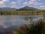
Looking across Cove Lake to Fork Mountain
-
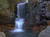
Bruce Creek Falls on the Cumberland Trail
-
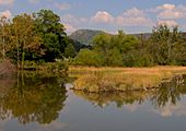
An inlet along Cove Lake, with Devil's Racetrack rising in the distance
-
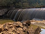
Caryville Dam


