
Frozen Head State Park facts for kids
Quick facts for kids Frozen Head State Park |
|
|---|---|

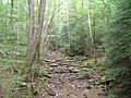
The Judge Branch on the west side of Frozen Head
|
|
| Type | Tennessee State Park |
| Location | Wartburg, Tennessee |
| Area | 24,000 acres (97.12 km2; 37.50 sq mi) |
| Operated by | Tennessee Department of Environment and Conservation |
| Open | Year round |
| Website | Frozen Head State Park |
Frozen Head State Park and Natural Area is a special place in Morgan County, Tennessee. It's a state park located in the Crab Orchard Mountains, between the towns of Wartburg and Petros. This park is home to some of the tallest mountains in Tennessee west of the Blue Ridge.
Frozen Head State Park covers about 24,000 acres (97 km2) of land. Most of this area, except for about 330 acres (1.3 km2), is a protected natural area. The land here changes a lot, from 1,300 ft (400 m) high valleys to mountains over 3,000 ft (910 m) tall. There are 14 peaks that reach or go above 3,000 feet (910 m). The highest peak is called Frozen Head, which is 3,324 feet (1,013 m) high. It gets its name because its top often looks "frozen" with snow in colder months. From the highest points in the park, you can see amazing views of East Tennessee's main land features: the Cumberland Plateau, the Tennessee Valley, and the Great Smoky Mountains far away.
Contents
What is the Geography of Frozen Head?

The Crab Orchard Mountains are part of the larger Cumberland Mountains range. They are made mostly of sandstones and shales from about 300 million years ago. Even though these rocks are younger than the rocks in the Appalachian Mountains to the east, both mountain systems were formed when two huge land plates, the North American and African plates, crashed into each other.
Frozen Head State Park is mostly found in the Flat Fork Valley. This valley is a flat area between Bird Mountain and Old Mac Mountain. A stream called Flat Fork starts on the southern side of Bird Mountain and flows through the valley. It eventually joins Crooked Fork near Wartburg. Flat Fork and most other streams in the park flow into the Emory River, which also starts near Bird Mountain.
Frozen Head mountain, the park's tallest peak, is in the middle of the park. It's part of a long ridge that goes from State Highway 62 up to the peak and then continues north. Most of the park's other big mountains stretch out from this main ridge.
What is the Frozen Head State Natural Area?

In 1988, most of Frozen Head State Park was made into a state natural area. This means that 330 acres (1.3 km2) of land, where the park offices and campground are, is the only part that can be developed. Because of this special protection, the park has a very old and healthy forest.
In the lower parts of Frozen Head, you'll find a mixed forest with many types of trees. These include hemlock, maple, tulip poplar, oak, and hickory trees. As you go higher up the mountains, the forest changes to mostly oak trees, especially white oak and tulip poplar. On the very tops of the mountains and along the ridges, you'll mostly see chestnut oak and shortleaf pine.
What are the Park's Features?
Mountains in the Park

Frozen Head is the highest mountain at 3,324 feet (1,013 m). It's in the middle of the park and has a long ridge that looks like a natural amphitheater.
Chimney Top Mountain is 3,120 feet (950 m) tall and is in the park's southwest corner. It has cool, steep sandstone caprocks at its top. The highest one is about 15–20 feet tall. There's also a rock shelter at the base of this caprock.
Bird Mountain is 3,142 feet (958 m) high and is in the northwest part of the park. It stretches for about 7 miles (11 km). The Emory River starts on the northern slopes of Bird Mountain.

Old Mac Mountain is 3,132 feet (955 m) tall and is near the park's center. It rises from the Flat Fork Valley and stretches for almost 5 miles (8.0 km).
Mart Fields is also 3,132 feet (955 m) high and is in the southwest part of the park. It's a thinly forested knob where Chimney Top Mountain and Frozen Head meet.
Some other important mountains near the park, but outside its borders, include Big Brushy Mountain, Big Fodderstack, Fork Mountain, and Buffalo Mountain (known for its windmills).
Waterfalls to See
Emory Gap Falls is a 25-foot (7.6 m) tall waterfall. You can find it where Flat Fork begins, on the southeast side of Bird Mountain.
DeBord Falls is a 12-foot (3.7 m) tall waterfall. It's located on Panther Branch, just before the creek joins Flat Fork.
Other Interesting Features
You'll find many rock outcroppings throughout the park, especially on the higher mountains. Some of these rocks form natural shelters. The biggest rock shelter is near the top of Frozen Head and you can reach it by a short trail. You can also see old mine entrances from a former prison and a building used by the Civilian Conservation Corps (CCC) along the South Old Mac Mountain Trail.
How Did Frozen Head Become a Park?

Long ago, the area that is now Frozen Head State Park was a hunting ground for the Cherokee people. In 1805, this land became part of the United States. Early European settlers arrived soon after, but they mostly stayed in the fertile valleys, avoiding the rugged mountains.
Over the years, businesses sometimes bought the Frozen Head area for its natural resources. However, it stayed mostly untouched until 1894. That's when the state of Tennessee bought the land to use for mining coal. In 1911, a company called Emory River Lumber Company bought the Frozen Head area and cut down most of the trees for timber. Big logging operations continued until 1925.

In 1933, Tennessee Governor Hill McAlister set aside a large part of this land to create Morgan State Forest. The Civilian Conservation Corps (CCC), a group of young men who worked on public projects during the Great Depression, arrived that same year. They built roads and facilities to help manage the forest. The CCC worked here until 1941.
A large part of Morgan State Forest was burned in a forest fire in 1952. Eighteen years later, in 1970, the land was given to the parks division to create Frozen Head State Park. In 1988, most of the park became a state natural area. This means that development is limited to a 330-acre (1.3 km2) area where the Flat Fork and Judge Branch streams meet.
What Facilities Does the Park Offer?

Frozen Head has a developed area with a campground that has 20 campsites. There's also a larger group campsite for up to 75 people. The park has an amphitheater that can hold 240 people, plus several picnic areas and sports fields. Most of these main facilities are in the 330 acres (1.3 km2) area set aside for development in the Flat Fork Valley.
There are also eleven backcountry campsites spread throughout the park. Most of these are between 1 and 4 miles (6.4 km) from the parking lot. Popular backcountry spots include Tub Springs, Mart Fields, Chimney Tops, Panther Gap, and Bird Mountain.
The Frozen Head Observation Platform

In 2006, the park built a new observation deck at the top of Frozen Head. It replaced an old fire tower. This deck rises above the trees, giving you an amazing 360-degree view of everything around you. You can see the Great Smoky Mountains and the Tennessee Valley to the east. Walden Ridge, where the Tennessee Valley meets the Cumberland Plateau, is visible to the south.
To the north and northeast, you'll see Fork Mountain. You might even spot the 360-foot (110 m) tall windmills of the Tennessee Valley Authority's Buffalo Mountain Wind Park beyond the mountain. These windmills were built in 2004 to create "Green Energy."
Big Fodderstack is right to the east, and Big Brushy Mountain stands tall above the community of Petros to the southeast. You can also see the former Brushy Mountain State Prison through the trees at the base of Frozen Head. Like Fork Mountain, Big Fodderstack and Big Brushy have marks from strip mining, a way of getting coal from the ground.
Indian Knob, a smaller peak of Frozen Head Mountain, is right to the south. You can sometimes see parts of the Watts Bar Lake on the Tennessee River, about 20 miles (32 km) to the south.
Mart Fields and Chimney Top Mountain are visible to the southwest. To the west, you'll see the Flat Fork Valley and the slopes of Bird Mountain. In the distance, you can spot the Wartburg area and the Obed River watershed.
Hiking Trails for Exploration

Frozen Head State Park has about 80 miles (130 km) of hiking trails that connect all its different parts. Most trails start near the park offices. Some other trailheads are at Armes Gap (above Petros) and off Highway 62. Most trails are just for hiking, but you can ride mountain bikes on the Lookout Tower Trail, which goes to the top of Frozen Head.

The Chimney Top Trail connects the park offices to Frozen Head by way of Chimney Top Mountain. This trail goes up Rough Ridge, down into the Taylor Branch Valley, and then up Chimney Top Mountain. From the top, it goes east across the ridge to Mart Fields. The caprocks on Chimney Top are steep, about 15–20 feet high, but you can climb them without special gear.
Hiking trails also go up the north and south sides of Old Mac Mountain and Bird Mountain. These trails meet the main ridge trails. The Bird Mountain trails start at the campground. The Old Mac Mountain trails start near the parking lot, along a short interpretive trail.
A part of the Cumberland Trail goes along the south side of Bird Mountain. When this trail is finished, the Frozen Head section of the Cumberland Trail will be about 20-mile (32 km) long. It will connect to the Smoky Mountain section to the northeast and the Obed River section to the southwest.
The Barkley Marathons
The Barkley Marathons is a very unusual and tough ultramarathon race held in the park every year since 1984. Runners try to complete a 100-mile (160 km) course in less than 60 hours. The course isn't marked, and it goes through very rough and wild terrain. As of 2017, only fifteen people have ever finished this incredibly difficult race!
Images for kids
-
The Judge Branch on the west side of Frozen Head
- Frozen Head landforms
- Frozen Head tower
