Wartburg, Tennessee facts for kids
Quick facts for kids
Wartburg, Tennessee
|
|
|---|---|
|
City
|
|

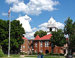
Morgan County Courthouse in Wartburg
|
|

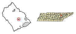
Location of Wartburg in Morgan County, Tennessee.
|
|
| Country | United States |
| State | Tennessee |
| County | Morgan |
| Established | 1840s |
| Incorporated | 1968 |
| Named for | Wartburg Castle |
| Area | |
| • Total | 1.13 sq mi (2.92 km2) |
| • Land | 1.13 sq mi (2.92 km2) |
| • Water | 0.00 sq mi (0.00 km2) |
| Elevation | 1,312 ft (400 m) |
| Population
(2020)
|
|
| • Total | 848 |
| • Density | 752.44/sq mi (290.50/km2) |
| Time zone | UTC-5 (Eastern (EST)) |
| • Summer (DST) | UTC-4 (EDT) |
| ZIP code |
37887
|
| Area code(s) | 423 |
| FIPS code | 47-78100 |
| GNIS feature ID | 2405678 |
Wartburg is a small city in Morgan County, Tennessee, USA. It is also the county seat, which means it's where the county government is located. In 2020, about 848 people lived here.
Contents
History of Wartburg
In 1805, the Cherokee people gave up the land that is now Morgan County to the United States. They did this by signing a treaty. Soon after, the first settlers started to arrive in the area.
Wartburg was started in the mid-1840s by Georg Friedrich Gerding. He was a land speculator, which means he bought large areas of land hoping to sell them for more money later. Gerding planned to create German settlements in the Cumberland Plateau region. He formed a company called the East Tennessee Colonization Company to help with this plan.
Georg Friedrich Gerding was born in Germany in 1800. He became a successful businessman in New York. He even received an award from the King of Belgium for starting the first shipping line between Antwerp and New York. He bought 300,000 acres of land and founded Wartburg in 1844. He gave land for the town square, a church, and a cemetery.
German and Swiss immigrants came to Wartburg to escape difficult economic times in their home countries. They traveled from New Orleans up the Mississippi River and Cumberland River to Nashville. From there, they used ox carts to reach the Cumberland Plateau. The first of these settlers arrived in 1845. New groups of immigrants continued to arrive until 1855.
The new settlement was named after Wartburg Castle in Germany. This castle is famous because Martin Luther translated parts of the Bible there. The first six streets in Wartburg were named after European cities. However, these names were changed a few years later to Rose, Church, Maiden (originally Maidenland), Kingston, Mill, and Cumberland.
Wartburg grew slowly because most immigrants lived on farms outside the town. By 1850, the town had Gerding's house and store, a church, a school, a doctor's office, and a few small homes. Some early residents were skilled professionals from Europe. These included an architect, a musician, a painter, and doctors.
During the American Civil War, Morgan County generally supported the Union. However, Wartburg itself was divided. Georg Gerding, the city's founder, supported the Confederacy. Other important people in town supported the Union. In January 1862, Confederate soldiers fought with the Union Home Guard near Wartburg. By March 1862, Confederate citizens were reportedly expelled from the area. In June 1863, Union General William P. Sanders marched through Wartburg. He captured 104 Confederate soldiers nearby.
In 1870, Morgan County decided to move its county seat to Wartburg. The old county seat, Montgomery, was very small. A new courthouse was built in Wartburg in 1871. The current courthouse, which looks like a castle, was built in 1904.
By the early 1900s, Wartburg had grown to about 500 people by 1920. At that time, the city had a bank, a school, a newspaper, several stores, and a billiard hall. In 1968, Wartburg officially became an incorporated city. Roy McNeal was elected as its first mayor.
Geography and Location

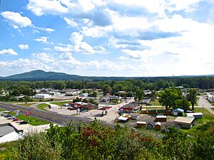
Wartburg is located in the Crab Orchard Mountains. These mountains are part of the Cumberland Mountains, near the eastern edge of the Cumberland Plateau. Bird Mountain is a large mountain east of Wartburg. It rises from the edge of the city and stretches for about 10 miles (16 km). Its highest point is at Frozen Head State Park.
The Emory River starts near the top of Bird Mountain. It flows west along the north side of the mountain, passing just north of Wartburg. The river then turns south and flows into Watts Bar Lake, which is part of the Tennessee River. The Obed River flows from Cumberland County through a beautiful gorge. It then joins the Emory River just west of Wartburg.
Wartburg is located where two main roads meet. U.S. Route 27 connects the city to Kentucky to the north. It also connects to Harriman and Interstate 40 to the south. State Route 62 connects Wartburg to Oak Ridge to the east. It also leads to rural areas of Morgan and Fentress County to the west.
The city covers a total area of about 1.0 square mile (2.6 square kilometers). All of this area is land.
Population Information
Wartburg's population has changed over the years:
- 1880: 150 people
- 1890: 206 people
- 1970: 541 people
- 1980: 761 people
- 1990: 932 people
- 2000: 890 people
- 2010: 918 people
- 2020: 848 people
In 2020, there were 848 people living in Wartburg. There were 377 households and 218 families.
Fun Things to Do
Wartburg is a great place for outdoor activities. It is the main office for the Obed Wild and Scenic River. This area is managed by the National Park Service. Frozen Head State Park and Lone Mountain State Forest are also nearby.
The Catoosa Wildlife Management Area is just west of Wartburg. The Big South Fork National River and Recreation Area is a few miles north. These places offer many opportunities for hiking, fishing, and enjoying nature.
Famous People from Wartburg
- Joseph Knaffl (1861–1938), a well-known photographer.
See also
 In Spanish: Wartburg (Tennessee) para niños
 | Charles R. Drew |
 | Benjamin Banneker |
 | Jane C. Wright |
 | Roger Arliner Young |

