Crittenden, Kentucky facts for kids
Quick facts for kids
Crittenden, Kentucky
|
|
|---|---|

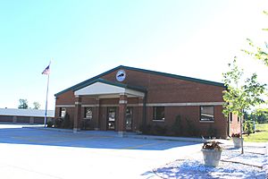
Crittenden City Hall
|
|

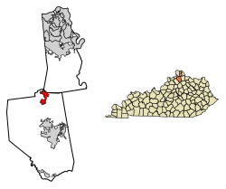
Location of Crittenden in Grant and Kenton counties.
|
|
| Country | United States |
| State | Kentucky |
| County | Grant |
| Area | |
| • Total | 3.43 sq mi (8.89 km2) |
| • Land | 3.40 sq mi (8.82 km2) |
| • Water | 0.03 sq mi (0.07 km2) |
| Elevation | 925 ft (282 m) |
| Population
(2020)
|
|
| • Total | 4,023 |
| • Estimate
(2022)
|
4,091 |
| • Density | 1,181.50/sq mi (456.18/km2) |
| Time zone | UTC-5 (Eastern (EST)) |
| • Summer (DST) | UTC-4 (EDT) |
| ZIP code |
41030
|
| Area code(s) | 859 |
| FIPS code | 21-18568 |
| GNIS feature ID | 2404156 |
Crittenden is a city in Kentucky, United States. It is located in both Grant and Kenton counties. In 2020, the city had a population of 4,023 people. This number has grown quite a bit over the years. For example, in 2000, there were 2,401 people living there.
Where is Crittenden Located?
Crittenden is found in the northern part of Grant County. A small part of the city also reaches into Kenton County. It is close to the border of Boone County.
A major highway called Interstate 75 goes right through Crittenden. This highway makes it easy to travel. You can drive north about 27 miles to reach Cincinnati. If you head south, you can get to Lexington in about 56 miles.
Another important road, U.S. Route 25, also runs through the center of Crittenden. This road is parallel to Interstate 75. It connects Crittenden to nearby towns. For instance, you can go north 7 miles to Walton. Or, you can go south 11 miles to Williamstown, which is the main town of Grant County.
The city of Crittenden covers a total area of about 3.43 square miles (8.9 square kilometers). Most of this area is land. Only a very small part, about 0.03 square miles (0.07 square kilometers), is water.
The Story of Crittenden
People might have started living in the area that is now Crittenden as early as 1812. For many years, the community had a different name: "Pin Hook."
In 1834, the name was changed to Crittenden. This was done to honor a famous person from Kentucky. His name was John J. Crittenden. He was a very important leader in Kentucky and later became the state's governor.
How Many People Live Here?
| Historical population | |||
|---|---|---|---|
| Census | Pop. | %± | |
| 1850 | 250 | — | |
| 1860 | 290 | 16.0% | |
| 1870 | 295 | 1.7% | |
| 1880 | 323 | 9.5% | |
| 1890 | 440 | 36.2% | |
| 1900 | 199 | −54.8% | |
| 1910 | 189 | −5.0% | |
| 1920 | 185 | −2.1% | |
| 1930 | 265 | 43.2% | |
| 1940 | 232 | −12.5% | |
| 1950 | 287 | 23.7% | |
| 1960 | 287 | 0.0% | |
| 1970 | 359 | 25.1% | |
| 1980 | 597 | 66.3% | |
| 1990 | 731 | 22.4% | |
| 2000 | 2,401 | 228.5% | |
| 2010 | 3,815 | 58.9% | |
| 2020 | 4,023 | 5.5% | |
| 2022 (est.) | 4,091 | 7.2% | |
| U.S. Decennial Census | |||
The population of Crittenden has grown a lot over time. In 2000, there were 2,401 people. By 2010, this number increased to 3,815. The latest count in 2020 showed 4,023 residents. In 2022, it was estimated to be around 4,091 people.
In 2000, about 32.5% of the people living in Crittenden were under 18 years old. The average age of people in the city was 28 years. This means it is a relatively young community.
Most households in Crittenden in 2000 were families. About 46.7% of households had children under 18 living with them. The average household had about 2.76 people.
See also
 In Spanish: Crittenden (Kentucky) para niños
 | Toni Morrison |
 | Barack Obama |
 | Martin Luther King Jr. |
 | Ralph Bunche |


