Crittenden County, Kentucky facts for kids
Quick facts for kids
Crittenden County
|
|
|---|---|

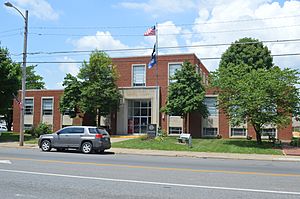
Crittenden County Courthouse in Marion
|
|

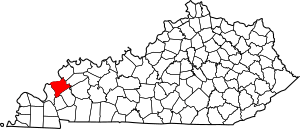
Location within the U.S. state of Kentucky
|
|
 Kentucky's location within the U.S. |
|
| Country | |
| State | |
| Founded | 1842 |
| Named for | John J. Crittenden |
| Seat | Marion |
| Largest city | Marion |
| Area | |
| • Total | 371 sq mi (960 km2) |
| • Land | 360 sq mi (900 km2) |
| • Water | 11 sq mi (30 km2) 3.0%% |
| Population
(2020)
|
|
| • Total | 8,990 |
| • Estimate
(2023)
|
8,974 |
| • Density | 24.23/sq mi (9.356/km2) |
| Time zone | UTC−6 (Central) |
| • Summer (DST) | UTC−5 (CDT) |
| Congressional district | 1st |
Crittenden County is a place in Kentucky, a state in the United States. In 2020, about 8,990 people lived there. The main town and county seat is Marion. The county was started in 1842. It was named after John J. Crittenden, who was a senator and later a governor of Kentucky.
Contents
History of Crittenden County
Crittenden County is located near the Ohio and Tradewater Rivers. It was created on April 1, 1842. This area became Kentucky's 91st county. It was named after John J. Crittenden, a famous U.S. senator and governor. The first county seat was in Crooked Creek, but it moved to Marion two years later.
Early Settlers and Trails
Long ago, the Chickasaw Road crossed Crittenden County. This old path was used by Native Americans. They used it to hunt animals that crossed the Ohio River. The animals were going to find salt licks in Illinois.
The first settler in the area was James Armstrong. He came from South Carolina in 1786. He built a log cabin. His family joined him five years later. Other families also came to live there. In the early 1800s, Flynn's Ferry was started. This was where the trail crossed the river.
Crittenden County During the Civil War
During the American Civil War, many people in Crittenden County supported the Confederate side. Not much fighting happened here. However, both armies often passed through the county. Some small battles did take place.
In December 1864, a Confederate general named Hylan B. Lyon led a raid. His men burned the county courthouse. They burned seven courthouses in total across western Kentucky. The Union Army was using these buildings as barracks. The Confederates let local people save important records before burning the buildings.
Industries and Economy
Crittenden County has many valuable natural resources. These include fluorspar, zinc, coal, and limestone. Marion was a big industrial town in the 1840s. It was known for its large fluorspar mining industry. This industry was biggest in 1947. It has slowly become smaller since then.
Iron production was also important in the mid-1800s. Several iron furnaces were built in the county. One of them was owned by Andrew Jackson. Other things made here included lumber and glass. Today, farming is a very important part of the county's economy. In 1992, many people in the county lived on farms.
Geography of Crittenden County
Crittenden County covers about 371 square miles. Most of this area is land, about 360 square miles. About 11 square miles is water. The Ohio River forms the county's northwestern border with Illinois.
Major Highways in Crittenden County
 U.S. Route 60
 U.S. Route 641
 Kentucky Route 70
 Kentucky Route 91
 Kentucky Route 120
 Kentucky Route 295
Counties Next to Crittenden County
- Hardin County, Illinois (to the northwest)
- Union County (to the north)
- Webster County (to the northeast)
- Caldwell County (to the southeast)
- Lyon County (to the south)
- Livingston County (to the west)
Population Information
| Historical population | |||
|---|---|---|---|
| Census | Pop. | %± | |
| 1850 | 6,351 | — | |
| 1860 | 8,796 | 38.5% | |
| 1870 | 9,381 | 6.7% | |
| 1880 | 11,688 | 24.6% | |
| 1890 | 13,119 | 12.2% | |
| 1900 | 15,191 | 15.8% | |
| 1910 | 13,296 | −12.5% | |
| 1920 | 13,125 | −1.3% | |
| 1930 | 11,931 | −9.1% | |
| 1940 | 12,115 | 1.5% | |
| 1950 | 10,818 | −10.7% | |
| 1960 | 8,648 | −20.1% | |
| 1970 | 8,493 | −1.8% | |
| 1980 | 9,207 | 8.4% | |
| 1990 | 9,196 | −0.1% | |
| 2000 | 9,384 | 2.0% | |
| 2010 | 9,315 | −0.7% | |
| 2020 | 8,990 | −3.5% | |
| 2023 (est.) | 8,974 | −3.7% | |
| U.S. Decennial Census 1790-1960 1900-1990 1990-2000 2010-2021 |
|||
In 2000, there were 9,384 people living in Crittenden County. There were 3,829 households. The population density was about 26 people per square mile. The median age in the county was 40 years old.
Towns and Communities
City
- Marion (This is the main town and where the county government is.)
Smaller Towns (Census-designated places)
Other Small Communities
- Centerville
- Dycusburg
- Frances
- Irma
- Levias
- Mattoon
- Mexico
- Midway
- Nunn
- Piney
- Piney Fork
- Repton
- Shady Grove
- Sheridan
- Tribune
- View
- Weston
Old or Abandoned Towns
Education
Students in Crittenden County go to schools run by Crittenden County Schools. These schools are located in Marion.
Famous People from Crittenden County
- Lee Cruce: He was the second Governor of Oklahoma.
- William J. Deboe: He was a U.S. Senator for Kentucky.
- Ollie M. James: He was a U.S. Representative and later a U.S. Senator for Kentucky.
- Walter Walker: He was a U.S. Senator for Colorado.
- Kenneth W. Winters: He is a member of the Kentucky State Senate.
- Forrest Pogue: He was a famous military historian. He wrote about General George C. Marshall.
- Shelby Hearon: She was a well-known author.
See also
 In Spanish: Condado de Crittenden (Kentucky) para niños
 | Madam C. J. Walker |
 | Janet Emerson Bashen |
 | Annie Turnbo Malone |
 | Maggie L. Walker |

