
Crofton, London facts for kids
Quick facts for kids Crofton |
|
|---|---|
 208 bus route at Crofton junction |
|

Crofton
|
|
| Population | 14,632 (2011 Census) |
| OS grid reference | TQ445658 |
| • Charing Cross | 13.6 mi (21.9 km) NW |
| London borough | |
| Ceremonial county | Greater London |
| Region | |
| Country | England |
| Sovereign state | United Kingdom |
| Post town | ORPINGTON |
| Postcode district | BR5, BR6 |
| Police | Metropolitan |
| Fire | London |
| Ambulance | London |
| EU Parliament | London |
| UK Parliament |
|
| London Assembly |
|
Crofton is a friendly neighborhood in southeast London, England. It's part of the London Borough of Bromley. Before 1965, it was in the old county of Kent. Crofton is about 13.6 miles (21.9 km) southeast of central London. It is located near other areas like Orpington, Petts Wood, and Bromley Common.
Contents
Crofton's Past: A Journey Through Time

Did you know people lived in Crofton a very long time ago? A Roman settlement was here from about 140 AD to 400 AD. You can still see the remains of a Roman villa, which is now a small museum. It's right next to the Orpington train station!
The name Crofton comes from an old English word. It means 'farm on a rounded hill'. For many years, Crofton was a quiet, rural area. Things started to change after 1868 when the Orpington train station opened. This made it easier for people to travel.
St Paul's Church on Crofton Road was built in 1887. It was later rebuilt in 1958. Between World War I and World War II, many new houses were built. Crofton grew and became a part of the larger town of Orpington.
What's in Crofton?
Crofton has two small areas with shops. You can find them on Crofton Lane and Kelvin Parade. These are great places to pick up everyday items.
To the northwest of Crofton, you'll find Crofton Wood. This is a special natural area. It's protected because it has important plants and animals. It's a lovely place to explore nature.
Getting Around Crofton
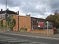
Crofton doesn't have its own train station. However, Orpington railway station is very close by. It's just to the east of Crofton. From Orpington station, you can catch trains on the South Eastern Main Line.
Buses are a great way to travel in Crofton. There are many bus routes that run during the day. There's even a night bus and a school bus route. You can take buses like the 61, 208, 353, and R2. These buses connect Crofton to many nearby towns and areas. You can easily reach places like Bromley town centre, Catford, and Petts Wood.
Images for kids
-
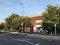
Shops on Crofton Lane
-
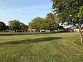
Oregon Square Open Space, with the Kelvin Parade shops at the far end
-
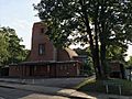
St Paul's Church, built in 1958 by AB Knapp-Fisher
-
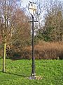
Crofton village sign
-
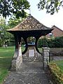
Crofton War Memorial at St Paul's Church
-
Crofton Roman Villa Museum


