Croton River watershed facts for kids
This page is about the Croton River watershed, a natural area. For the part of New York City's water system, see Croton Watershed

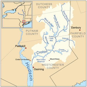
The Croton River watershed is a large natural area where all the rain and snow eventually drain into the Croton River and its seven smaller rivers. It's like a giant bowl that collects water in southwestern New York State.
This watershed covers a huge area of over 350 square miles (906 square kilometers) in Putnam and Westchester counties. It holds an amazing 115 billion US gallons (435 billion liters) of fresh water! This water comes from many places.
The Croton River watershed includes seven rivers, twelve reservoirs, three special controlled lakes, a big natural lake called Lake Mahopac, and countless smaller lakes and ponds.
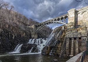
Most of this water travels through pipes to the Jerome Park Reservoir in the Bronx. From there, it is sent to homes and businesses in New York City. If there's too much water for the city, the extra water flows over the New Croton Dam at the New Croton Reservoir. This water then goes into the Croton River and eventually reaches the Hudson River. This happens near Croton-on-Hudson, New York, about 30 miles (48 kilometers) north of New York City.
Contents
What is the Croton River Watershed?

The Croton River watershed is a natural area that collects water. It is a 361 square mile (935 square kilometer) basin where all the water drains into the Croton River and its smaller streams.
It is important to know that this watershed is not the same as the Croton Watershed. The "Croton Watershed" is a term for the specific rivers, reservoirs, dams, and pipes that are part of the New York City water supply system.
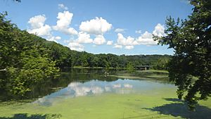
Many small natural lakes and ponds, including the large Lake Mahopac, are part of the river's natural watershed. However, New York City does not own or control these specific lakes, even though their water eventually flows into the city's system.
The Croton River (pronounced KROH-tən) is a river in southern New York State. It has three main branches: the West Branch, Middle Branch, and East Branch. The water from these branches, along with their connected reservoirs, forms the northern part of New York City's water system.
After the three branches meet, the Croton River and its tributary, the Muscoot River, flow into the Muscoot Reservoir. Then, the water goes into the New Croton Reservoir. From there, the New Croton Aqueduct carries the water to New York City through the Jerome Park Reservoir in the Bronx.
Any water that New York City does not need flows over a spillway at the New Croton Dam. This water then empties into the Hudson River at Croton-on-Hudson, New York. This spot is about 30 miles (48 kilometers) north of New York City.
Parts of the Croton River Watershed
The Croton River watershed is made up of many different waterways and bodies of water.
Rivers and Streams
Natural Lakes and Ponds
- Lake Mahopac
- Lake Carmel
- Long Pond (Carmel)
Reservoirs
These are large, artificial lakes built to store water.
- Boyds Corner
- West Branch
- Middle Branch
- Croton Falls and Diverting
- East Branch and Bog Brook
- Titicus
- Cross River
- Amawalk
- Muscoot
- New Croton
Controlled Lakes
These are natural lakes whose water levels can be managed.
The New Croton Aqueduct
The New Croton Aqueduct is a long underground tunnel. It was finished in 1890. This aqueduct carries water from the New Croton Reservoir in Westchester and Putnam counties all the way to New York City.
Fun Activities in the Watershed
Some fun outdoor activities are allowed in certain parts of the Croton Watershed. You can find rules and information about these activities on the official website here.
 | William M. Jackson |
 | Juan E. Gilbert |
 | Neil deGrasse Tyson |


