Crowe River facts for kids
Quick facts for kids Crowe River |
|
|---|---|

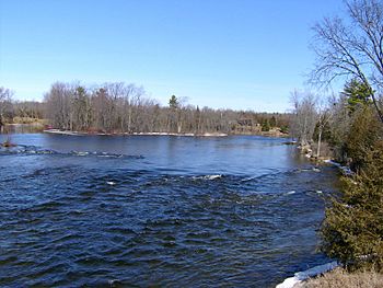
Crowe River north of Crowe Bridge
|
|
|
Location of the mouth of the Crowe River in southern Ontario
|
|
| Country | Canada |
| Province | Ontario |
| Region | Southern Ontario |
| Counties |
|
| Physical characteristics | |
| Main source | Paudash Lake Paudash, Faraday township, Hastings County 341 m (1,119 ft) 44°58′50″N 77°58′25″W / 44.98056°N 77.97361°W |
| River mouth | Trent River Trent Hills, Northumberland County 159 m (522 ft) 44°22′23″N 77°45′49″W / 44.37306°N 77.76361°W |
| Basin features | |
| River system | Lake Ontario drainage basin |
| Basin size | 2,000 km2 (770 sq mi) |
| Tributaries |
|
The Crowe River is a cool river in southern Ontario, Canada. It flows through four different counties: Haliburton, Hastings, Northumberland, and Peterborough. This river is part of the huge Lake Ontario drainage basin. It eventually flows into the Trent River.
Contents
Where the Crowe River Flows
The Crowe River starts its journey at Paudash Lake. It flows southeast from the lake, going under Ontario Highway 28. It also goes over the Paudash Lake Dam near the town of Paudash. This is in Faraday township, which is in Hastings County.
The River's Path
The river then turns southwest. It passes through a small part of Highlands East in Haliburton County. After that, it heads south into North Kawartha in Peterborough County. The Crowe River then turns south-southeast. It goes back into Hastings County, flowing through Wollaston township.
The Gut and Lakes
In Wollaston, the river flows through a narrow, deep gorge called The Gut Conservation Area. This gorge is about 230 metres (750 ft) long and 30 metres (98 ft) high. It's only 5 to 10 metres (16 to 33 ft) wide! The Green River joins the Crowe River here. Then, the Crowe River reaches Tangamong Lake.
The river continues south from Tangamong Lake, flowing over a waterfall. Copeway Creek, another small river, joins it. The Crowe River then enters Marmora and Lake township at Mud Turtle Lake. This is east of the town of Vansickle.
Through More Lakes
Next, the river goes back into Peterborough County. It flows through Havelock-Belmont-Methuen township. It passes through Cordova Lake and over the Cordova Lake Dam. Then it reaches Belmont Lake. Here, a big river called the North River joins it.
The Crowe River leaves Belmont Lake from Crowe River Bay. It flows over Belmont Dam into Crowe Lake. It enters Marmora and Lake township again. The Beaver Creek joins the Crowe River here. Finally, the river reaches the community of Marmora on Ontario Highway 7.
Final Stretch to the Trent River
In Marmora, the Crowe River flows over the Marmora Dam. It then heads southwest into Stirling-Rawdon township. It passes over two waterfalls at Callaghan's Rapids Conservation Area. These falls are about one metre (3 ft 3 in) high and 40 to 60 metres (130 to 200 ft) wide.
The river then enters Trent Hills in Northumberland County. It flows over the Allan Mills dam. It also passes over several waterfalls at Crow Bridge Conservation Area. The Crowe River finally reaches its mouth at Crowe Bay on the Trent River. This is just upstream from the Trent–Severn Waterway Crowe Bay lock and dam. The Trent River then flows into the Bay of Quinte on Lake Ontario at Trenton.
The River's Surroundings
The northern part of the Crowe River's area is mostly wild Canadian Shield land. Not many people live there. When the river reaches Marmora, it enters a flat area made of Paleozoic limestone. But even here, you can see unusual rocky parts of the Canadian Shield sticking out. The river drains an area of about 2,000 square kilometres (770 sq mi).
How the River is Used
Long ago, the Crowe River was used to float logs down to sawmills in Marmora. Today, the river helps make electricity. It powers several small hydroelectric power stations. The waterfalls at Callaghans Rapids Conservation Area and Crowe Bridge Conservation Area are popular spots. People love to go kayaking there in the spring and swimming in the summer.
Rivers Joining the Crowe River
- Beaver Creek (joins from the left)
- North River (joins from the right)
- Copeway Creek (joins from the left)
- Green River (joins from the left)
Towns Along the River
- Marmora
 | Isaac Myers |
 | D. Hamilton Jackson |
 | A. Philip Randolph |


