
Paudash Lake facts for kids
Quick facts for kids Paudash Lake |
|
|---|---|

Sunset over Lower Paudash
|
|

Paudash Lake
Location in Ontario
|
|
| Location | Haliburton County, Ontario |
| Coordinates | 44°58′N 78°03′W / 44.967°N 78.050°W |
| Type | Glacial lake, oligotrophic, dimictic |
| Primary inflows | Natural springs, Silent Lake, Deer Lake, Anderson Lake, and Centre Lake |
| Primary outflows | Crowe River |
| Basin countries | Canada |
| Max. length | 14.2 km (8.8 mi) |
| Max. width | 5.1 km (3.2 mi) |
| Surface area | 7.55 km2 (1,870 acres) |
| Max. depth | 46 m (151 ft) |
| Residence time | 3 years |
| Surface elevation | 343.5 m (1,127 ft) |
| Frozen | Mid-December to Late April |
| Islands | Mullet, Johnston, Ross, Moulds, Burnt, Stringer, Big, and Birch |
| Settlements | (None on lake) |
Paudash Lake is a beautiful lake located in south-central Ontario, Canada. It's found in Haliburton County, near Silent Lake Provincial Park, and not too far from Algonquin Provincial Park. The small communities of Cardiff and Paudash are close by.
What people call Paudash Lake is actually two connected lakes: 'Paudash' and 'Lower Paudash'. These lakes are part of the Crowe River system, which eventually flows into the Trent River.
Contents
- Exploring Paudash Lake's Geography
- Water and Climate Conditions
- History of Paudash Lake
- Ojibwa People and Paudash Lake
- Wildlife Around Paudash Lake
- Trees of Paudash Lake
- Protecting Paudash Lake's Environment
- Roads and Services at Paudash Lake
- Summer Fun at Paudash Lake
- Winter Activities at Paudash Lake
- Marinas, Food, and Places to Stay
- Images for kids
Exploring Paudash Lake's Geography
Paudash Lake has several distinct areas. These include Lower Paudash Lake (also called Outlet Bay) to the east, North Bay to the north, Joe Bay to the southwest, and Inlet Bay to the northeast. The lake covers an area of about 7.5 km2 (1,900 acres). It can get as deep as 46 m (151 ft), which is like a 15-story building!
Fish Species in Paudash Lake
The lake is home to many different kinds of fish. You can find largemouth bass, smallmouth bass, walleye, and lake trout. Other fish include perch, pumpkinseed, northern cisco, white sucker, and various small bait fish.
How Glaciers Shaped the Lake
The area around Paudash Lake has over 10,000 lakes. These were formed about 11,000 years ago by huge sheets of ice called glaciers. These glaciers scraped away a thick layer of soil, revealing the ancient rock underneath. This area is part of the Canadian Shield, which is a very old and rocky part of North America.
The Canadian Shield often has thin soil, sometimes less than 30 cm (0.98 ft) deep. You can also see a lot of exposed rock, like the amazing pink granite cliffs in North Bay. These cliffs rise hundreds of feet out of the lake! Most of the lake's shore is covered with trees and thick plants. The glaciers carved out all the lakes in this region, giving them their rocky shorelines.
Paudash Lake's local rock includes limestone (now marble). This helps to naturally balance the water and protect it from acid rain.
Water and Climate Conditions
The water in Paudash Lake is very clear. In the summer, the top six feet of water usually warms up to 27 to 28 °C (81 to 82 °F). The lake gets its water from many small streams that feed into the Crowe River. These streams come from four smaller lakes: Silent Lake, Deer Lake, Anderson Lake, and Centre Lake. Experts estimate that all the water in Paudash Lake is replaced every three years.
The lake typically freezes completely from mid-December until the third week of April. That's when the ice usually breaks up.


History of Paudash Lake
Paudash Lake was named after Chief George Paudash. He was a member of the Crane-doodem (clan) from the Chippewa (Ojibwa) Nation of the Hiawatha Reserve at Rice Lake.
The first pioneer families settled in this area in the early 1870s. One of these original families, the McGillivrays, are still part of the Paudash Lake community today. In 1875, Malcolm McGillivray Sr. received a large piece of land that jutted into Paudash Lake. He later built the first bridge over the narrow section between the upper and lower lakes.
The first summer cottage on the lake was built on Big Island in North Bay in the early 1920s by the Johnson family. However, not much building happened on the lake until the late 1930s. This is when two main highways, Highway 28 and Highway 35, were built, making it easier to reach the area. After World War II, in the late 1940s, more development began.
Cottage Life Today
Major cottage building on Paudash Lake really took off in the 1950s and 1960s. Today, the lake is mostly developed with about 640 properties. Many new buildings involve replacing older 50 or 60-year-old cottages with modern ones. About 15% of the land around the lake, including one large island, is still untouched "Crown land" (government-owned land).
Ojibwa People and Paudash Lake
On November 5, 1818, six Chiefs of the Chippewa (Ojibwa) Nation, including Chief Paudash, sold a large area of southern Ontario to the Crown. This area included Paudash Lake. Chief Paudash's "mark" on the treaty was a small drawing of a Crane, which represented his Crane-doodem (clan).
Even though the lake is named after an Ojibwa Chief, experts believe the Ojibwa tribe did not have permanent settlements in most of Haliburton. This was partly because they were nomadic, meaning they moved from place to place to hunt, fish, and gather food. They would stay in one spot only as long as needed, much like modern sports fishermen move from one lake to another.
The Ojibwa tribe did use the Haliburton area as a summer hunting ground. In the 1870s and 1880s, small hunting parties would still pass through the Paudash Lake area during the summer. While they didn't have a permanent camp on the lake, they would sometimes spend the night at Wolf Point on Joe Bay or at the north end of Silent Lake.
Paudash Lake likely had an earlier name in the Anishinaabe language spoken by the Ojibwa. However, many lakes were named by early settlers after the main Indigenous family or chief who seemed to use that lake. This suggests that the Paudash family often visited Paudash Lake and considered it their hunting and fishing territory.
Wildlife Around Paudash Lake
Paudash Lake is surrounded by a lot of semi-wilderness. This means that right behind the cottages, you can find wild areas.
Mammals
Larger mammals living here include the American black bear, moose, white-tailed deer, and the eastern Canadian wolf. Smaller mammals are also common, such as the red fox, beaver, raccoon, muskrat, mink, otter, and various squirrels, rabbits, and chipmunks.
Reptiles and Amphibians
You can find several types of turtles, including snapping, spotted, and painted turtles. There are also many frogs like the American toad, spring peeper, and bullfrog. There are no poisonous snakes in Haliburton, but you might see non-poisonous ones like the common garter snake or common water snake.
Birds
The unofficial symbol of this region is the loon, which is also Ontario's provincial bird. You'll often see loons on the lake. Other water birds include the great blue heron, the great egret, and the hooded merganser. Many types of ducks, gulls, and other water birds also live here.

Trees of Paudash Lake
Paudash Lake is located in the Great Lakes-St. Lawrence Forest region. This means it has a mix of trees found in both northern and southern forests.
Native trees in the area include different kinds of maple (silver, red, sugar), pine (jack, red, white), and aspen (largetooth, trembling). You'll also see yellow and white birch, black and white spruce, and various types of oak and ash. Other trees include cherry, balsam fir, eastern tsuga (hemlock), tamarack, balsam poplar, white cedar, American beech, ironwood, and speckled alder.

Protecting Paudash Lake's Environment
For the past 40 years, a lot of effort has gone into keeping Paudash Lake as natural and clean as possible. Rules are in place for installing septic tank systems, making sure they are far from the lake to prevent pollution. Regular checks are done to ensure no sewage leaks into the lake.
While Paudash is a natural lake, its water level is controlled by a small dam at the east end, where the Crowe River flows out. This dam helps keep the lake at a steady level.
To build a boat dock, you need a special permit and plan. This ensures the dock won't harm the lake's plants and animals. Property owners are also encouraged to keep their shorelines natural with native plants and avoid using fertilizers on their lawns.
Today, Paudash Lake is a great example of successful conservation. A local watershed conservation authority works to continue protecting the lake. Efforts have been made to keep the natural wetland areas undisturbed. These wetlands act like natural filters for the water and provide safe homes for wildlife.
The Paudash Lake Conservation Association, started in 1973, works hard to maintain and improve the lake's water quality. They test the water each year for things like phosphorus and clarity, and the results are usually normal. The lake has 33 wetlands, and some of these are very important for the environment. The association educates the public about how these wetlands help filter water and control floods.
The association has also led projects to plant native plants along the shoreline and offers advice to residents on how to protect water quality, manage septic tanks, and prevent erosion. In 2004, they started developing a Paudash Lake Management Plan, which was published in 2006. This plan includes many recommendations for protecting the lake's water quality, water levels, and fish.

Roads and Services at Paudash Lake
Most properties on Paudash Lake have electricity from Hydro One and phone service from Bell Telephone. Cell phone service is also available. While high-speed internet is available through satellite, cable TV is not. You can get TV channels over the air or by satellite.
Some areas, like Joe Bay and parts of Lower Paudash Lake and Inlet Bay, have roads that are open all year. However, many shoreline areas in North Bay, Outlet Bay, and Inlet Bay can only be reached by boat. North Bay, in particular, is mostly inaccessible by car in the winter, only by snowmobile. The land around the lake is mostly wilderness, except for the narrow strip of cottages along the shore.
Mail service is available five days a week, either at your property or at central mailboxes on the lake access roads. Delivery services like FedEx and UPS also serve the area.

Summer Fun at Paudash Lake
North Bay has a public sandy beach with restrooms. You can get to it by car or by boat. The beach also has a boat launching ramp. An annual regatta (boat race event) takes place at the beach.
You can enjoy water-skiing and wakeboarding on the lake. Many different types of boats are seen, from classic ski boats to modern wakeboard boats and small sailboats. Boat traffic on the lake is usually not too busy, even on holiday weekends.
The lake has many fish species, and there's an annual Rock Bass Derby for children, organized by the Conservation Association. The Bancroft Village Playhouse, a theater built in the 1920s, is about 20 minutes away from the lake.


Winter Activities at Paudash Lake
Like other freshwater lakes in Ontario, Paudash Lake freezes over in winter. The ice can be 46 to 61 centimetres (18 to 24 in) thick, strong enough to support a fully loaded dump truck! During this time, people often travel across the lake on snowmobiles, and ice fishing is very popular.
Just over 1.6 km (0.99 mi) away, Silent Lake Provincial Park offers over 40 km (25 mi) of cross-country ski trails. These trails have cozy, wood-fired warming huts along the way.
The Paudash Trail Blazers Snowmobile Club maintains snowmobile trails throughout the region in winter. Central Ontario has over 5,500 km (3,400 mi) of connected, groomed snowmobile trails. These trails link up to Ontario's huge system of 43,000 km (27,000 mi) of maintained snowmobile trails. This system is regularly checked by snowmobile clubs and the Ontario Provincial Police.


Marinas, Food, and Places to Stay
There are three marinas on Paudash Lake that offer boat services:
- The Anchorage Resort: Located on McGillivray Road, on the channel between the upper and lower lake.
- The Paudash Lake Marina: Found on the lower lake, off McGillivray Road.
- Landing Point Marine: Also on the lower lake, off Highway 28.
If you're looking for a place to stay or eat, here are some options:
- The Somerset Inn: Located on the lower lake, off Highway 28.
- The Anchorage Resort: Off McGillivray Road, on the channel between the upper and lower lake.

Images for kids
-
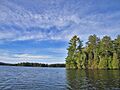
Towards North Bay
-
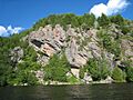
200 Foot Cliffs in North Bay
-
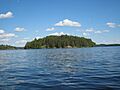
BIG Island in North Bay
-
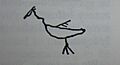
The Mark of Chief Paudash (a crane), used on the treaty of 1818 which deeded to the Crown the area of Paudash Lake, et al.


