Cumanayagua facts for kids
Quick facts for kids
Cumanayagua
|
|||
|---|---|---|---|

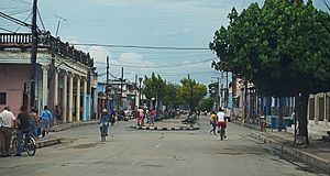
A road in the town centre
|
|||
|
|||

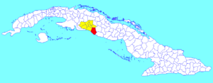
Cumanayagua municipality (red) within
Cienfuegos Province (yellow) and Cuba |
|||
| Country | Cuba | ||
| Province | Cienfuegos | ||
| Town rights | 1804 | ||
| Area | |||
| • Total | 1,099 km2 (424 sq mi) | ||
| Elevation | 60 m (200 ft) | ||
| Population
(2022)
|
|||
| • Total | 47,118 | ||
| • Density | 42.874/km2 (111.04/sq mi) | ||
| Time zone | UTC-5 (EST) | ||
| Area code(s) | +53-432 | ||
| Website | https://cumanayagua.gob.cu/ | ||
Cumanayagua is a lively town and a special area (called a municipality) in Cuba. It's part of the Cienfuegos Province. This town sits in a beautiful valley, close to the Guamuhaya Mountains. These mountains are also known as the Escambray Mountains. Cumanayagua is about 23 kilometers (14 miles) east of Cienfuegos. Cienfuegos is the main city of the province.
Contents
History of Cumanayagua
Long ago, Cumanayagua was home to the Taíno people. They were the native people of Cuba before the Spanish arrived. The name "Cumanayagua" comes from their language, Arawak. Its exact meaning is a bit of a mystery.
Some people think it means "The place filled with flowers of Royal Palms." Others believe it means "The place of Cuma and Anayagua." Cuma was a leader of the area. Anayagua was his daughter and would have become the next leader.
The town was first started by Spanish settlers and Cubans during colonial times. It had a longer name back then. On May 3, 1804, it officially became a town. Its name was San Felipe de Cumanayagua. Later, in 1878, the name changed to Santa Cruz de Cumanayagua. Finally, around the year 1900, it got its shorter Taino name, which it still has today.
Geography and Nature
Cumanayagua is in the southeastern part of the Cienfuegos province. It is right by the Caribbean Coast. It also borders the provinces of Villa Clara and Sancti Spíritus.
The area includes part of the Escambray Mountain Range. You can find beautiful nature reserves here. These include Topes de Collantes and Pico San Juan. The town is south of the Avilés Reservoir. The Hanabanilla River flows through the area.
Cumanayagua shares its borders with other towns. These include Cienfuegos, Palmira, Cruces, Manicaragua, and Trinidad. The municipality also has many smaller villages and places. Some of these are Arimao, Barajagua, and Camilo Cienfuegos. Others are Entronque de Minas, Gavillán, and Guajimico. You can also find Hoyo de Padilla, La Clara, and La Sierrita. Finally, there are Las Moscas, Playa El Inglés, Playa Yaguanabo, San Blas, San Francisco, and San Juan.
People and Population
In 2022, about 47,118 people lived in Cumanayagua. The total area of the municipality is 1,099 square kilometers (424 square miles). This means there are about 43 people living in each square kilometer. This number tells us how crowded or spread out the population is.
What They Produce
The land in Cumanayagua is good for farming. Farmers in the municipality grow many different crops. Two important crops are citrus fruits and coffee. These products are important for the local economy.
See also
 In Spanish: Cumanayagua para niños
 | Selma Burke |
 | Pauline Powell Burns |
 | Frederick J. Brown |
 | Robert Blackburn |


