Currahee Mountain facts for kids
Quick facts for kids Currahee Mountain |
|
|---|---|

Currahee Mountain
|
|
| Highest point | |
| Elevation | 1,735 ft (529 m) NAVD 88 |
| Geography | |
| Location | Stephens County, Georgia, U.S. |
| Parent range | Blue Ridge Mountains |
| Topo map | USGS Ayersville 34083-E |
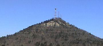
Currahee Mountain is a famous mountain located in Stephens County, Georgia. It is found near the town of Toccoa. The name "Currahee" comes from the Cherokee word quu-wa-hi. This word means "stand alone," which perfectly describes the mountain.
Currahee Mountain is part of the Georgia Piedmont region. It rises sharply about 800 feet (240 meters) above the land around it. This makes it the highest point in Stephens County. Part of the mountain is also within the Chattahoochee National Forest. On clear days, you can see its 1,735-foot (529-meter) summit from far away. It is a well-known landmark southeast of Georgia's Blue Ridge Mountains.
Contents
History of Currahee Mountain
Currahee Mountain has played a role in history for a long time.
Early History
The mountain was one of the important landmarks mentioned in the Treaty of Hopewell. This treaty was signed between the United States and the Cherokee Nation. It helped define land boundaries. Later, Benjamin Hawkins used the mountain to mark the "Hawkins Line." This line also helped to set land borders.
Civil War Battle
During the American Civil War, a battle took place near the mountain. On October 12, 1864, Confederate troops fought Union troops. This event is known as the Battle of Narrows or the Battle of Currahee. The Confederate soldiers won this battle. Their victory is said to have protected the local area from being damaged by Union troops.
Training Site for Soldiers
Currahee Mountain became very famous because of its use as a training site.
Band of Brothers
The mountain gained international fame from the TV miniseries Band of Brothers. This show was created by Tom Hanks and Steven Spielberg. It showed how American paratroopers trained at Camp Toccoa, Georgia. These soldiers ran up and down Currahee Mountain as part of their tough training. The mountain's name became a motto for these brave paratroopers. They often said, "Three miles up, three miles down." This phrase describes the challenging run they had to do.
Colonel Robert F. Sink Memorial Trail
Today, a special path called the Colonel Robert F. Sink memorial trail follows Currahee Mountain Road. It goes from the old site of Camp Toccoa all the way to the mountain's top. A special plaque marks the start of the trail. It honors "Col. Bob" Sink from the Five-O-Sinks, who were part of the 506th Parachute Infantry Regiment.
This trail is now used for the Annual Currahee Challenge. This event is a race held every fall. People can choose to run three or six miles on the mountain.
Activities and Features
Currahee Mountain is not just for history buffs and runners.
Outdoor Activities
The mountain is also a popular spot for outdoor adventures. Many people enjoy rock climbing and rappelling here. These activities involve climbing up or lowering oneself down steep rock faces.
Weather Radio Station
At the very top of Currahee Mountain, there is a radio tower. This tower holds the NOAA Weather Radio station WWH24. This station broadcasts important weather information. It serves parts of northeast Georgia and upstate South Carolina. The weather reports come from the National Weather Service office in Greer.
 | Claudette Colvin |
 | Myrlie Evers-Williams |
 | Alberta Odell Jones |


