Custer County, Colorado facts for kids
Quick facts for kids
Custer County
|
||
|---|---|---|

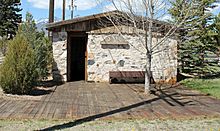
The Westcliffe Jail is listed on the National Register of Historic Places.
|
||
|
||

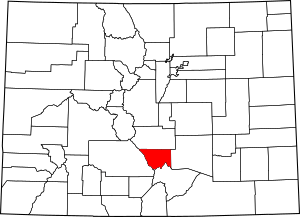
Location within the U.S. state of Colorado
|
||
 Colorado's location within the U.S. |
||
| Country | ||
| State | ||
| Founded | March 9, 1877 | |
| Named for | George Armstrong Custer | |
| Seat | Westcliffe | |
| Largest town | Silver Cliff | |
| Area | ||
| • Total | 740 sq mi (1,900 km2) | |
| • Land | 739 sq mi (1,910 km2) | |
| • Water | 1.3 sq mi (3 km2) 0.2%% | |
| Population
(2020)
|
||
| • Total | 4,704 | |
| • Density | 6.4/sq mi (2.5/km2) | |
| Time zone | UTC−7 (Mountain) | |
| • Summer (DST) | UTC−6 (MDT) | |
| Congressional district | 7th | |
Custer County is a county located in the state of Colorado in the United States. In 2020, about 4,704 people lived there. The main town, or county seat, is Westcliffe.
Contents
History of Custer County
Custer County was formed on March 9, 1877. It was created from the southern part of Fremont County. The county was named after Lt. Colonel George Armstrong Custer. He had passed away the year before. The main town, or county seat, moved a few times. It started in Ula, then moved to Rosita in 1878. Later, it went to Silver Cliff in 1886. Finally, in 1928, it settled in Westcliffe.
The Silver Rush Era
The county was a very busy place in the 1870s. This was during a time called the silver rush. Thousands of people came to the area. They were all hoping to find silver. Some famous mines included the Geyser Mine, near Silver Cliff. There was also the Bassick Mine, close to the old town of Querida. Another big mine was the Bull Domingo, north of Silver Cliff.
Railroads and Ranching
In the late 1800s, a railroad line was built. It went through the Grape Creek Canyon. However, this railroad had to close for good. This was after several big floods damaged it. The old building where the trains stopped is now a historical landmark. You can find it in the town of Westcliffe.
After the silver mines ran out, many people left. The population went down a lot. But new people came in their place: cattle ranchers. They built many irrigation ditches. These ditches helped bring water to the land. Ranching is still an important activity in the Wet Mountain Valley today.
Geography of Custer County
Custer County covers about 740 square miles. Most of this area, 739 square miles, is land. Only a small part, about 1.3 square miles, is water.
Mountains and Valleys
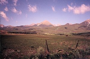
The county has a very rugged landscape. It would be hard to get around without roads. The lowest part of the county is about 6,000 feet high. But most of the area is made of rough mountains. The county seat, Westcliffe, is about 7,800 feet high. Westcliffe and the nearby town of Silver Cliff are in the Wet Mountain Valley. This valley sits at the base of the Sangre de Cristo Mountains.
The peaks of the Sangre de Cristo Mountains are to the west. Some of these mountains are over 14,000 feet tall. Crestone Peak is the highest at 14,294 feet. It is the 7th highest mountain in Colorado that is over 14,000 feet.
Natural Areas
A large part of Custer County is covered by National Forest land. This includes parts of the Sangre de Cristo Mountains to the west. It also includes parts of the Wet Mountains to the east. The only large lake in the county is the DeWeese Reservoir. It is located in the northern part of the Wet Mountain Valley.
Neighboring Counties
Custer County shares borders with these counties:
- Fremont County to the north
- Pueblo County to the east
- Huerfano County to the southeast
- Saguache County to the west
Main Roads
Protected Areas and Trails
- San Isabel National Forest
- Sangre de Cristo Wilderness
- Frontier Pathways National Scenic and Historic Byway
Bicycle Trails
- TransAmerica Trail Bicycle Route
- Western Express Bicycle Route
Population of Custer County
| Historical population | |||
|---|---|---|---|
| Census | Pop. | %± | |
| 1880 | 8,080 | — | |
| 1890 | 2,970 | −63.2% | |
| 1900 | 2,937 | −1.1% | |
| 1910 | 1,947 | −33.7% | |
| 1920 | 2,172 | 11.6% | |
| 1930 | 2,124 | −2.2% | |
| 1940 | 2,270 | 6.9% | |
| 1950 | 1,573 | −30.7% | |
| 1960 | 1,305 | −17.0% | |
| 1970 | 1,120 | −14.2% | |
| 1980 | 1,528 | 36.4% | |
| 1990 | 1,926 | 26.0% | |
| 2000 | 3,503 | 81.9% | |
| 2010 | 4,255 | 21.5% | |
| 2020 | 4,704 | 10.6% | |
| 2023 (est.) | 5,534 | 30.1% | |
| U.S. Decennial Census 1790-1960 1900-1990 1990-2000 2010-2020 |
|||
In 2000, there were 3,503 people living in Custer County. The population density was about 5 people per square mile. Most of the people living in the county were White.
The population has changed a lot over the years. In 1880, there were over 8,000 people. This was during the silver rush. After the mines closed, the population dropped. By 1970, only 1,120 people lived there. Since then, the population has grown steadily. In 2020, it reached 4,704 people.
Communities in Custer County
Towns
- Silver Cliff
- Westcliffe (County seat)
Unincorporated Communities
These are smaller communities that are not officially towns.
- Cold Spring
- Fairview
- Greenwood
- McKenzie Junction
- San Isabel
- Tanglewood Acres
- Wetmore
Ghost Towns
These are places where people used to live, but now they are mostly empty.
See also
 In Spanish: Condado de Custer (Colorado) para niños
 | Charles R. Drew |
 | Benjamin Banneker |
 | Jane C. Wright |
 | Roger Arliner Young |


