
Cyclone Viyaru facts for kids
| Cyclonic storm (IMD scale) | |
|---|---|
| Tropical storm (SSHWS) | |

Cyclonic Storm Viyaru over the Bay of Bengal on May 13
|
|
| Formed | May 10, 2013 |
| Dissipated | May 17, 2013 |
| Highest winds | 3-minute sustained: 85 km/h (50 mph) 1-minute sustained: 95 km/h (60 mph) |
| Lowest pressure | 990 hPa (mbar); 29.23 inHg |
| Fatalities | At least 24 total |
| Areas affected | Sri Lanka, Southeastern India, Thailand, Myanmar, Bangladesh |
| Part of the 2013 North Indian Ocean cyclone season | |
Cyclonic Storm Viyaru, also called Cyclonic Storm Mahasen, was a strong tropical cyclone. It moved across the Bay of Bengal. This storm caused concern for Myanmar and Bangladesh.
Viyaru started as a low pressure area in the Bay of Bengal in early May. It grew slowly. By May 10, it became a depression. This means it was a weak tropical storm. On May 11, it gained strength and became a full cyclonic storm. This was the first storm of that year's season. At first, no one was sure where it would go. But it moved closer to eastern India. On May 14, Viyaru changed direction and headed northeast.
Myanmar asked many people to leave their homes to stay safe from the storm. Some people tried to escape by boat. Sadly, these boats became too crowded. At least one boat sank, and eight people died. The storm had a very large cloud area. This brought bad weather to Sri Lanka, Thailand, and southeastern India. Strong storms in India and Sri Lanka caused a lot of damage. They also led to 15 deaths. One person died in Thailand.
The name Mahasen caused some debate in Sri Lanka. Some people felt the name was wrong. They said Mahasen was a Sinhala king who brought good times to the island. So, they thought naming a destructive storm after him was not right. Because of this, Sri Lankan officials did not use the name Mahasen for the storm.
Cyclone Viyaru hit Southern Bangladesh on May 16, 2013. The wind speed was about 100 kilometers per hour (62 miles per hour).
How Cyclonic Storm Viyaru Formed

A cloudy area first appeared on May 4. It slowly moved east. By May 8, it became a low pressure area. A special weather pattern helped the storm grow. This pattern also helped another storm, Tropical Storm Jamala, form.
On May 10, weather experts saw that the storm was getting more organized. They issued a special alert for a tropical cyclone. Later that day, they officially named it 01B. It then became a depression, and then a deep depression.
Latest Storm Information (May 16, 2013)
On May 16, 2013, at 8:30 AM (local time), Cyclonic Storm Mahasen was near latitude 21°N and longitude 90°E. This was about 240 kilometers (150 miles) south-southeast of Kolkata. It was also about 240 kilometers (150 miles) southwest of Chittagong.
The storm was expected to stay strong. It was moving northeast. Experts thought it would cross the Bangladesh coast near Chittagong by the evening of May 16. The strongest winds were about 85 kilometers per hour (53 miles per hour). Wind gusts could reach 100 kilometers per hour (62 miles per hour). The lowest pressure in the storm's center was about 988 millibars.
Images for kids
-
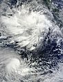
Viyaru (top) as a depression off the coast of Sumatra, along with Moderate Tropical Storm Jamala to its south, on May 10
-
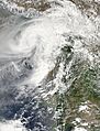
Viyaru making landfall in Feni, Bangladesh on May 16
-
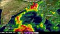
Satellite-estimated rainfall totals across the Bay of Bengal from May 6 to 16 derived from NASA's Tropical Rainfall Measuring Mission. Areas in purple, seen along the Bangladesh–Myanmar border, indicate amounts in excess of 500 mm (20 in); the highest estimated value was 544 mm (21.4 in).
_and_Jamala(south)_May_10_2013_0425Z.jpg)


