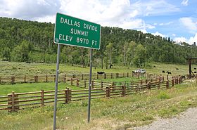
Dallas Divide facts for kids
Quick facts for kids Dallas Divide |
|
|---|---|

The sign at the top of the pass
|
|
| Elevation | 8,983 ft (2,738 m) |
| Traversed by | State Highway 62 |
| Location | Ouray / San Miguel counties, Colorado, U.S. |
| Range | San Juan Mountains/Uncompahgre Plateau |
| Coordinates | 38°05′40″N 107°53′18″W / 38.09444°N 107.88833°W |
| Topo map | USGS Sams |
The Dallas Divide is a high mountain pass in Colorado, United States. It sits at an elevation of about 8,983 feet (2,738 meters) above sea level. This pass is an important route for State Highway 62. It is located about 12 miles (19 kilometers) west of the town of Ridgway.
Contents
What is the Dallas Divide?
A mountain pass is like a low spot or a gap between mountains. It makes it easier to travel from one side to another. The Dallas Divide connects different areas. It is a saddle, meaning it's a dip between two higher landforms. To the south, you'll find the San Juan Mountains. To the north, there's the Uncompahgre Plateau.
Where is Dallas Divide Located?
This pass is in the state of Colorado, United States. It crosses between two counties: Ouray County and San Miguel County. It also separates two important river areas.
The pass divides the Uncompahgre River watershed from the San Miguel River watershed. A watershed is an area of land where all the water drains into a specific river or lake. So, water flowing from one side of the pass goes to the Uncompahgre River. Water from the other side goes to the San Miguel River.
How Did Dallas Divide Get Its Name?
The Dallas Divide gets its name from Dallas Creek. This creek drains the basin on the north side of Mount Sneffels. It then flows into the Uncompahgre River.
The divide is also named after George M. Dallas. He was an important person in American history. George M. Dallas served as the 11th Vice President of the United States. He was Vice President from 1845 to 1849.
A Look Back: Dallas Divide's History
The Dallas Divide has been an important route for travel for a long time. People have used it to move between different towns and areas.
Early Roads and Travel
The first toll road was built over the Dallas Divide in 1880. A toll road is a road where you pay a fee to use it. This road connected the town of Dallas (near Ridgway) with Telluride. This made it easier for people and goods to travel between these places.
The Railroad Era
Later, in 1890, a railroad was built over the divide. This was the Rio Grande Southern Railroad. It also ran from Ridgway to Telluride. Railroads were a very important way to transport things back then. They helped connect mining towns and other communities in the mountains.
 | Bayard Rustin |
 | Jeannette Carter |
 | Jeremiah A. Brown |

