
Damascus, Maryland facts for kids
Quick facts for kids
Damascus, Maryland
|
|
|---|---|
 |
|

Location of Damascus, Maryland
|
|
| Country | United States |
| State | Maryland |
| County | Montgomery |
| Named for | Damascus, Syria |
| Area | |
| • Total | 14.27 sq mi (36.95 km2) |
| • Land | 14.24 sq mi (36.89 km2) |
| • Water | 0.02 sq mi (0.06 km2) |
| Elevation | 712 ft (217 m) |
| Population
(2020)
|
|
| • Total | 17,224 |
| • Density | 1,209.30/sq mi (466.92/km2) |
| Time zone | UTC−5 (Eastern (EST)) |
| • Summer (DST) | UTC−4 (EDT) |
| ZIP code |
20872
|
| Area code(s) | 301, 240 |
| FIPS code | 24-21475 |
| GNIS feature ID | 2389391 |
Damascus is a community in Montgomery County, Maryland, United States. It is called a census-designated place, which means it's an area the government defines for counting people, but it's not an official town with its own local government. In the early 1900s, Damascus was an official town for about 25 years. As of the 2020 census, about 17,224 people live there. Damascus is located where three main roads meet in upper Montgomery County: Ridge Road (Route 27), Damascus Road (Route 108), and Woodfield Road (Route 124).
Contents
How Damascus Got Its Name
The name "Damascus" was first officially used in 1816. This was when the United States Congress approved a mail route through the area. Edward Hughes was in charge of this mail service. He named the community "The Pleasant Plains of Damascus" after the ancient city of Damascus, Syria.
History of Damascus
The land that is now Damascus was given to Nathaniel Pigman by the state of Maryland in 1783. On February 14, 1819, Edward Hughes, who fought in the War of 1812, bought about 40 acres of this land. He started dividing it into smaller pieces to sell.
In 1816, James Madison, who was the fourth U.S. president, made Edward Hughes the postmaster of the growing community. Hughes got permission from Congress to have a mail route go through the town. A newspaper in Frederick wrote about Hughes's new town. It said there were many chances for different types of workers. It mentioned two blacksmith shops, a saddler's shop, and a store. It also said that a tailor, a wheelwright, and a shoemaker were needed and would do well there.
People from Anne Arundel County and Montgomery County moved to the new town. On September 12, 1862, during the American Civil War, U.S. Army troops marched through Damascus. They used what is now Route 27 on their way to Sharpsburg. There, they fought against Confederate troops led by General Robert E. Lee in the Battle of Antietam.
Damascus was an official town from 1890 until 1914. At that time, the people living there asked for it to stop being an official town. They wanted Old Quaker Road, which had been used since the Revolutionary War, to be paved into a state highway. Today, Damascus is still a business center for nearby rural communities. These include Clagettsville, Browningsville, Cedar Grove, Woodfield, King's Valley, Purdum, and Lewisdale. Even though it has grown, many older residents feel it still has a small-town, country feel.
The Damascus Community Fair is an agricultural fair that started in 1940. It happens every year on the first weekend of September and brings in thousands of visitors. Groups like 4-H clubs and horse riding centers are still very popular in the area.
On November 17, 2009, the Damascus Heritage Society Museum opened its doors.
Damascus was the last "dry town" in Maryland until 2013. This means that for a long time, you couldn't buy beer or wine there. In 2013, the people of Damascus voted to allow the sale of beer and wine.
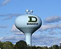
In 2017, parents and teachers in Damascus raised money to paint the town's water tower. They painted it with the green-and-gold "D" logo from the high school football helmets. This was a way to honor the successful football team. It also turned the plain tower into a special landmark for the town. The tower can be seen from all over Damascus and from the high school football field.
Geography of Damascus
Damascus does not have official borders because it is not an incorporated town. However, the United States Census Bureau recognizes it as a census-designated place. The United States Geological Survey also recognizes it as a populated area. The highest point in Damascus is about 847 feet (258 meters) above sea level. Other parts of the area can be as high as 866 feet (264 meters).
Damascus is located west of the fall line, which is where the Piedmont (a hilly area) meets the Atlantic coastal plain (a flatter area near the ocean). Damascus is known for its country scenery and farms owned by families. The area covers about 9.6 square miles (24.9 square kilometers), and it's all land.
The town sits on Parr's Ridge, which is a low ridge made of shale rock. This ridge rises about 300 feet above the land around it. From the open hilltops in the area, you can see far-off views of the Appalachian Mountains. On very clear days, you might even see two tall peaks in the Shenandoah National Park in Virginia, which are about 75 miles away.
Climate in Damascus
Damascus has warm, humid summers and generally cool winters. This type of weather is called a humid subtropical climate.
Because Damascus is higher up, has a rural landscape, and is in the northern part of Montgomery County, it gets the most snow in the county. On average, it gets about 32 inches of snow each winter. In the winter of 2009–2010, a record 98.4 inches of snow fell. The snow was deepest at 37 inches, which was the most ever recorded in the area. Sometimes, strong snowstorms from the coast can cause the area to shut down. In typical winters, snow comes and goes. In very cold winters, ponds might stay frozen, and the ground can stay covered in snow for a month or two.
Rainfall is usually plentiful and spread out throughout the year. On average, about 46 inches of rain falls each year. Thunderstorms are common from June to August. They sometimes bring hail and strong winds, but tornadoes are rare.
Temperatures are moderate. The average temperature in January is 31°F (-0.6°C), and in July, it's 74°F (23.3°C). Sometimes, very cold air from Canada can make temperatures drop below 0°F (-18°C) for a morning or two. In the summer, heat waves can bring a week or two of afternoons with temperatures of 90°F (32°C) or higher. Summer mornings are usually pleasant, with temperatures around the mid-60s°F (18-20°C).
| Climate data for Damascus, Maryland, 1991–2020 normals, extremes 1973–present | |||||||||||||
|---|---|---|---|---|---|---|---|---|---|---|---|---|---|
| Month | Jan | Feb | Mar | Apr | May | Jun | Jul | Aug | Sep | Oct | Nov | Dec | Year |
| Record high °F (°C) | 73 (23) |
78 (26) |
86 (30) |
91 (33) |
93 (34) |
97 (36) |
101 (38) |
102 (39) |
97 (36) |
90 (32) |
81 (27) |
75 (24) |
102 (39) |
| Mean maximum °F (°C) | 61.3 (16.3) |
63.3 (17.4) |
73.8 (23.2) |
83.7 (28.7) |
88.1 (31.2) |
90.9 (32.7) |
93.2 (34.0) |
91.7 (33.2) |
87.8 (31.0) |
80.2 (26.8) |
71.4 (21.9) |
62.6 (17.0) |
93.0 (33.9) |
| Mean daily maximum °F (°C) | 39.1 (3.9) |
42.6 (5.9) |
51.6 (10.9) |
63.9 (17.7) |
72.5 (22.5) |
80.2 (26.8) |
84.3 (29.1) |
82.6 (28.1) |
75.7 (24.3) |
64.5 (18.1) |
53.3 (11.8) |
43.5 (6.4) |
62.8 (17.1) |
| Daily mean °F (°C) | 31.8 (−0.1) |
34.4 (1.3) |
42.4 (5.8) |
53.4 (11.9) |
62.6 (17.0) |
70.9 (21.6) |
75.1 (23.9) |
73.6 (23.1) |
66.7 (19.3) |
55.5 (13.1) |
44.9 (7.2) |
36.5 (2.5) |
54.0 (12.2) |
| Mean daily minimum °F (°C) | 24.5 (−4.2) |
26.1 (−3.3) |
33.1 (0.6) |
42.9 (6.1) |
52.8 (11.6) |
61.5 (16.4) |
66.0 (18.9) |
64.6 (18.1) |
57.6 (14.2) |
46.5 (8.1) |
36.4 (2.4) |
29.5 (−1.4) |
45.1 (7.3) |
| Mean minimum °F (°C) | 5.4 (−14.8) |
9.9 (−12.3) |
16.0 (−8.9) |
28.1 (−2.2) |
36.7 (2.6) |
47.4 (8.6) |
55.3 (12.9) |
53.4 (11.9) |
43.1 (6.2) |
31.3 (−0.4) |
21.9 (−5.6) |
14.3 (−9.8) |
3.8 (−15.7) |
| Record low °F (°C) | −12 (−24) |
−9 (−23) |
3 (−16) |
18 (−8) |
28 (−2) |
38 (3) |
45 (7) |
41 (5) |
35 (2) |
21 (−6) |
9 (−13) |
−5 (−21) |
−12 (−24) |
| Average precipitation inches (mm) | 3.41 (87) |
2.98 (76) |
4.04 (103) |
3.62 (92) |
4.35 (110) |
4.67 (119) |
4.49 (114) |
4.18 (106) |
4.76 (121) |
4.01 (102) |
3.49 (89) |
3.89 (99) |
47.89 (1,218) |
| Average snowfall inches (cm) | 9.4 (24) |
11.1 (28) |
4.8 (12) |
0.2 (0.51) |
0.0 (0.0) |
0.0 (0.0) |
0.0 (0.0) |
0.0 (0.0) |
0.0 (0.0) |
0.0 (0.0) |
0.8 (2.0) |
5.1 (13) |
31.4 (79.51) |
| Average precipitation days (≥ 0.01 in) | 10.4 | 9.8 | 10.1 | 11.1 | 11.4 | 11.1 | 9.8 | 9.5 | 9.0 | 8.8 | 8.2 | 10.0 | 119.2 |
| Average snowy days (≥ 0.1 in) | 5.3 | 4.7 | 2.5 | 0.3 | 0.0 | 0.0 | 0.0 | 0.0 | 0.0 | 0.0 | 0.6 | 2.9 | 16.3 |
| Source: NOAA | |||||||||||||
Education and Athletics
Damascus High School (DHS) is famous for its championship sports teams. They are known as the Swarmin' Hornets. DHS is one of the few schools in Maryland that still holds its graduation ceremonies on the school's football field. It's a special tradition for many graduating students to walk across the field. They receive their diplomas in front of family and friends in the stands. Many townspeople also gather outside the fences to watch the ceremony. If the weather is bad, the graduation is held inside the high school auditorium.
General Colin Powell, who was a former U.S. Secretary of State and Chairman of the Joint Chiefs of Staff, spoke at Damascus High School's graduation in 2000. Billy Ripken, whose brother is famous baseball player Cal Ripken Jr., spoke at the 2013 graduation. Both ceremonies took place at the high school's football stadium.
Community Groups
The American Legion is an active group in Damascus. Since Post 171 was started after World War II, it has done many good things for the community. This includes putting up Christmas decorations downtown and giving scholarships to high school students. Post 171 also holds yearly ceremonies to remember Memorial Day and Veterans Day. These events happen at the Post home. The Post also sponsors a Junior Legion baseball team, which often wins championships.
Montgomery County Fire & Rescue Company 13 is located in Damascus. It is one of the oldest fire companies in Montgomery County. It started in 1940 with only volunteers. Since the late 1980s, the Damascus Volunteer Fire Department-Company 13 has had both full-time professionals and volunteers. Today, the company helps a fast-growing area with many homes and businesses.
Population and People
| Historical population | |||
|---|---|---|---|
| Census | Pop. | %± | |
| 2000 | 11,430 | — | |
| 2010 | 15,257 | 33.5% | |
| 2020 | 17,224 | 12.9% | |
| U.S. Decennial Census 2000–2020 |
|||
In 2000, there were 11,430 people living in Damascus. There were 3,710 households, and 3,079 families. The population density was about 1,187.5 people per square mile. There were 3,773 homes, with about 392 homes per square mile.
The ethnic makeup of the area was mostly white people (89.66%). There were also African American people (6.63%), Native American people (0.24%), Asian people (2.21%), and Pacific Islander people (0.03%). About 1.28% of people were from other races, and 1.95% were from two or more races. People of Hispanic or Latino background made up 4.31% of the population.
Out of the 3,710 households, 52.7% had children under 18 living with them. About 68.0% were married couples. About 11.3% had a female head of household with no husband present. And 17.0% were not families. About 13.1% of all households were single individuals. About 3.3% had someone living alone who was 65 years old or older. The average household had 3.08 people, and the average family had 3.38 people.
About 34.0% of the population was under 18 years old. About 6.0% were from 18 to 24. About 33.6% were from 25 to 44. About 21.1% were from 45 to 64. And 5.3% were 65 years or older. The average age was 34 years. For every 100 females, there were 94.1 males. For every 100 females aged 18 and over, there were 91.6 males.
The average income for a household in Damascus was $71,447. For a family, the average income was $76,462. Males earned an average of $51,590, while females earned $38,731. The average income per person in the area was $26,659. About 4.2% of families and 5.3% of the population lived below the poverty line. This included 6.8% of those under 18 and 0.9% of those 65 or older.
Images for kids
-
Damascus water tower sign
See also
 In Spanish: Damascus (Maryland) para niños
