Dayville, Oregon facts for kids
Quick facts for kids
Dayville, Oregon
|
|
|---|---|

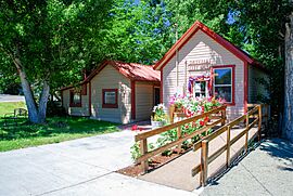
City Hall
|
|

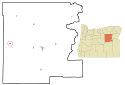
Location in Oregon
|
|
| Country | United States |
| State | Oregon |
| County | Grant |
| Incorporated | 1913 |
| Area | |
| • Total | 0.53 sq mi (1.36 km2) |
| • Land | 0.53 sq mi (1.36 km2) |
| • Water | 0.00 sq mi (0.00 km2) |
| Elevation | 2,346 ft (715 m) |
| Population
(2020)
|
|
| • Total | 132 |
| • Density | 250.95/sq mi (96.96/km2) |
| Time zone | UTC-8 (Pacific) |
| • Summer (DST) | UTC-7 (Pacific) |
| ZIP Code |
97825
|
| Area code(s) | 541 |
| FIPS code | 41-18300 |
| GNIS feature ID | 2412411 |
Dayville is a small city in Grant County, Oregon. It's located along U.S. Route 26. The city was officially started, or incorporated, in 1913. In 2010, about 149 people lived there.
Contents
Dayville's Past: A Look at Its History
Dayville gets its name from the John Day River. The first post office for Dayville was about 3 miles (5 km) west of where the city is now. In the mid-1800s, Dayville was on a wagon road. This road was later called The Dalles Military Road around 1870. It connected The Dalles on the Columbia River to gold mines near Canyon City. Dayville became an official city in 1913.
Exploring Dayville's Location and Nature
Dayville is about 125 miles (201 km) east of Bend. It is also about 233 miles (375 km) southeast of Portland. The city sits where the John Day River and the South Fork John Day River meet. U.S. Route 26 goes through Dayville from east to west. South Fork Road, which runs north and south, also meets the highway here.
Near Dayville, you can find many natural areas. Slightly southeast are the Murderers Creek State Wildlife Area, the Aldrich Mountains, and parts of the Malheur National Forest. To the southwest, you'll find the Black Canyon Wilderness, the Ochoco Mountains, and parts of the Ochoco National Forest.
About 6 miles (10 km) northwest of Dayville is Picture Gorge. This gorge is famous for Native American drawings, called pictographs, on its canyon walls. The Sheep Rock Unit of the John Day Fossil Beds National Monument is also nearby. This monument includes the Thomas Condon Paleontology Center. It also has the James Cant Ranch Historic District and museum. These are about 2 miles (3 km) north of Picture Gorge.
The United States Census Bureau says that Dayville covers about 0.53 square miles (1.36 square kilometers). All of this area is land.
People of Dayville: Population Facts
| Historical population | |||
|---|---|---|---|
| Census | Pop. | %± | |
| 1890 | 120 | — | |
| 1900 | 52 | −56.7% | |
| 1910 | 100 | 92.3% | |
| 1920 | 117 | 17.0% | |
| 1930 | 106 | −9.4% | |
| 1940 | 136 | 28.3% | |
| 1950 | 286 | 110.3% | |
| 1960 | 234 | −18.2% | |
| 1970 | 197 | −15.8% | |
| 1980 | 199 | 1.0% | |
| 1990 | 144 | −27.6% | |
| 2000 | 138 | −4.2% | |
| 2010 | 149 | 8.0% | |
| 2020 | 132 | −11.4% | |
| source: | |||
Dayville's Population in 2010
In 2010, the city had 149 people living in 72 households. About 41 of these were families. The population density was about 281 people per square mile (108 per square kilometer). Most of the people (96%) were White. About 3.4% were Native American. A small number (0.7%) were from two or more races.
About 19.4% of households had children under 18. Many households (47.2%) were married couples. The average household had about 2 people. The average family had about 2.6 people. The average age in Dayville was 50.8 years old. About 14.8% of residents were under 18. About 22.8% were 65 or older.
What Dayville Does: Economy and Community
Dayville is home to the Dayville School District. This school teaches students from kindergarten through 12th grade. In 2007, about 50 students attended the school. In 2002, the biggest employers in Dayville were the school district, the Dayville Merc (a grocery store), a cafe, a lounge, and a gas station.
The Dayville Presbyterian Church has been a welcoming place since the 1970s. It offers hospitality to bicyclists traveling along the TransAmerica Bicycle Trail.
See also
 In Spanish: Dayville para niños
 | William Lucy |
 | Charles Hayes |
 | Cleveland Robinson |


