
Derby Line, Vermont facts for kids
Quick facts for kids
Derby Line, Vermont
|
|
|---|---|
|
Village
|
|

Haskell Free Library and Opera House
|
|

Derby Line, Vermont
Location in Vermont

Derby Line, Vermont
Location in the United States
|
|
| Country | |
| State | |
| County | Orleans County |
| Town | Derby |
| Organized | June 16, 1977 |
| Area | |
| • Total | 0.73 sq mi (1.89 km2) |
| • Land | 0.73 sq mi (1.88 km2) |
| • Water | 0.00 sq mi (0.01 km2) |
| Elevation | 1,056 ft (322 m) |
| Population
(2020)
|
|
| • Total | 687 |
| • Density | 941/sq mi (363.5/km2) |
| Time zone | UTC-5 (EST) |
| • Summer (DST) | UTC-4 (EDT) |
| ZIP code |
05830
|
| Area code(s) | 802 |
| FIPS code | 50-17500 |
| GNIS feature ID | 1457154 |
Derby Line is a small village in Vermont, United States. It's part of the town of Derby in Orleans County, Vermont. What makes Derby Line special is that it sits right on the border between the U.S. and Canada!
The village is connected to a Canadian area called Rock Island in the town of Stanstead, Quebec. In 2020, about 687 people lived in Derby Line. One of its most famous buildings is the Haskell Free Library and Opera House, which is built right on the border itself!
Contents
History of Derby Line
Derby Line became a village in 1791. It's located on a hill in the northern part of Derby. The area was first settled in 1795. By the mid-1800s, people admired its beautiful farms and rich farmland. These farms had amazing views of Lake Memphremagog and the Green Mountains.
How the Border Was Drawn
The border between Canada and the United States was supposed to follow the 45th parallel (a line of latitude). However, when surveyors drew the line in the 1700s, they made a small mistake. The border ended up being slightly north of where it was planned. Derby Line was founded based on this slightly incorrect line. The border was officially confirmed in 1842 by the Webster–Ashburton Treaty.
Life on the Border
Derby Line is famous for its unique location on the Canada–United States border. This means some buildings are literally split between two countries!
The Haskell Free Library and Opera House
The Haskell Free Library and Opera House is a great example of this. It was built right on the international border and opened in 1904. The people who founded it, Carlos F. Haskell (an American businessman) and Martha Stewart Haskell (a Canadian), wanted people from both countries to use it.
Today, it's a historic site. People can visit the library from either side of the border without going through official border security. It's a symbol of friendship between the two countries.
Other Border Buildings
Besides the library, five other homes in Derby Line are split by the border. Most people living in these homes use the U.S. entrance to avoid issues with border officials. Crossing the border inside these buildings doesn't require special permission.
There was also a factory that made tools, which was divided by the border. The Canadian part of the factory closed in 1982. The part in Derby Line is still open and employs about 160 people.
Border Challenges
Living right on the border can have its challenges. For example, the U.S. Border Patrol has sometimes wanted to close streets that run between Derby Line and Stanstead. This is to help control illegal immigration.
In 2007, the village leaders of Derby Line even held a meeting with the Mayor and Council of Stanstead in Canada! This meant the Vermont village's meeting happened in a foreign country, but they still followed Vermont's rules. Interestingly, a phone call between Derby Line, Vermont, and Rock Island, Québec, counts as a local call.
Geography and Climate
Derby Line is a small village, covering about 0.7 square miles (1.8 square kilometers) of land.
Weather in Derby Line
The weather in Derby Line changes a lot throughout the year. Summers are warm, and winters are cold and snowy.
| Climate data for Derby Line, Vermont | |||||||||||||
|---|---|---|---|---|---|---|---|---|---|---|---|---|---|
| Month | Jan | Feb | Mar | Apr | May | Jun | Jul | Aug | Sep | Oct | Nov | Dec | Year |
| Record high °F (°C) | 64 (18) |
62 (17) |
83 (28) |
87 (31) |
92 (33) |
95 (35) |
98 (37) |
95 (35) |
96 (36) |
84 (29) |
74 (23) |
66 (19) |
98 (37) |
| Mean daily maximum °F (°C) | 26 (−3) |
31 (−1) |
41 (5) |
54 (12) |
69 (21) |
77 (25) |
81 (27) |
79 (26) |
70 (21) |
57 (14) |
43 (6) |
31 (−1) |
55 (13) |
| Mean daily minimum °F (°C) | 6 (−14) |
8 (−13) |
19 (−7) |
31 (−1) |
43 (6) |
52 (11) |
57 (14) |
55 (13) |
47 (8) |
37 (3) |
27 (−3) |
13 (−11) |
33 (1) |
| Record low °F (°C) | −38 (−39) |
−38 (−39) |
−32 (−36) |
−2 (−19) |
20 (−7) |
28 (−2) |
36 (2) |
32 (0) |
23 (−5) |
0 (−18) |
−7 (−22) |
−40 (−40) |
−40 (−40) |
| Average precipitation inches (mm) | 2.96 (75) |
2.16 (55) |
2.96 (75) |
2.93 (74) |
3.67 (93) |
3.93 (100) |
4.19 (106) |
4.18 (106) |
3.76 (96) |
3.45 (88) |
3.47 (88) |
3.12 (79) |
40.78 (1,035) |
| Average snowfall inches (cm) | 24.7 (63) |
17.2 (44) |
18.8 (48) |
6.9 (18) |
0.2 (0.51) |
0 (0) |
0 (0) |
0 (0) |
0.1 (0.25) |
1.1 (2.8) |
11 (28) |
23.1 (59) |
103.1 (263.56) |
People of Derby Line
| Historical population | |||
|---|---|---|---|
| Census | Pop. | %± | |
| 1900 | 309 | — | |
| 1910 | 390 | 26.2% | |
| 1920 | 640 | 64.1% | |
| 1930 | 683 | 6.7% | |
| 1940 | 661 | −3.2% | |
| 1950 | 767 | 16.0% | |
| 1960 | 849 | 10.7% | |
| 1970 | 834 | −1.8% | |
| 1980 | 874 | 4.8% | |
| 1990 | 855 | −2.2% | |
| 2000 | 776 | −9.2% | |
| 2010 | 673 | −13.3% | |
| 2020 | 687 | 2.1% | |
| U.S. Decennial Census | |||
In 2000, there were 776 people living in Derby Line. About 31.6% of households had children under 18. The average household had 2.36 people.
The population included people of all ages. About 24.7% were under 18, and 16.1% were 65 or older. The average age was 39 years old.
Economy and Jobs
The average income for a household in Derby Line was about $33,966 in 2000. For families, it was around $37,375.
Local Industry
A company that makes tools has a factory in Derby Line. It employs about 180 people from the area. This factory is a big part of the local economy.
Village Infrastructure
Infrastructure refers to the basic facilities and systems that a place needs to function.
Roads and Highways
Derby Line is at the very northern end of two major roads in the U.S.: Interstate 91 and US 5. These roads continue into Canada as Quebec Autoroute 55 and Quebec Route 143.
Derby Line and its Canadian neighbor, Stanstead, share many services.
- Drinking water for both towns comes from wells in Canada. It's stored in a reservoir in the U.S. and then sent out through pipes maintained by Canadians.
- Derby Line's sewage even travels across the border to Canada for treatment.
- Emergency teams, like fire and ambulance, also work together. They respond to calls on both the U.S. and Canadian sides of the border.
Images for kids
-
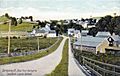
View from the station around 1908
-
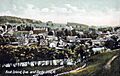
The twin villages around 1906
-
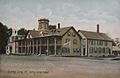
The Derby Line Hotel around 1908
-
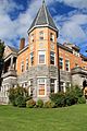
The Haskell Free Library on the US-Canada border, 2012


See also
 In Spanish: Derby Line para niños
