
Derrynasaggart Mountains facts for kids
Quick facts for kids Derrynasaggart Mountains |
|
|---|---|
| Irish: Sliabh Doire na Sagart | |
 |
|
| Highest point | |
| Peak | Mullaghanish |
| Elevation | 694 m (2,277 ft) |
| Geography | |
| Country | Republic of Ireland |
| Provinces of Ireland | Munster |
The Derrynasaggart Mountains are a mountain range in Ireland. They stretch across parts of Cork and Kerry. These mountains are easy to spot from the N22 road if you are heading towards Kerry.
You can also see the Derrynasaggart Mountains from several nearby towns. These include Clondrohid, Macroom, and Ballyvourney (which is Baile Mhuirne in Irish).
Contents
Exploring the Derrynasaggart Mountains
The Derrynasaggart Mountains are a natural landmark in southwestern Ireland. They form a beautiful part of the landscape in the province of Munster. These mountains offer great views and are important to the local area.
What is the Highest Point?
The highest peak in the Derrynasaggart Mountains is a mountain called Mullaghanish. It stands tall at 694 meters (about 2,277 feet) above sea level. Mullaghanish is located close to the town of Ballyvourney.
Mullaghanish: A Hub for Signals
Mullaghanish is not just a high point; it's also a very important place for communication. There are several radio transmitters located on its summit. These transmitters send out signals for many popular Irish broadcasters.
They help you listen to stations like RTÉ, TG4, Today FM, Radio Kerry, and Newstalk. This means Mullaghanish plays a big role in how people get their news and entertainment across the region.
Images for kids
-
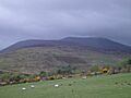
A view of the Derrynasaggart Mountains between Killarney and Macroom.
