
Macroom facts for kids
Quick facts for kids
Macroom
Maigh Chromtha (Irish)
|
|
|---|---|
|
Town
|
|

Macroom Castle entrance and cannons
|
|

Macroom
Location in Ireland

Macroom
Location in Europe
|
|
| Country | Ireland |
| Province | Munster |
| County | County Cork |
| Population
(2022)
|
4,096 |
| Time zone | UTC±0 (WET) |
| • Summer (DST) | UTC+1 (IST) |
| Eircode routing key |
P12
|
| Telephone area code | +353(0)26 |
| Irish Grid Reference | W337729 |

Macroom (/məˈkruːm/; Irish: Maigh Chromtha) is a busy market town in County Cork, Ireland. It sits in the valley of the River Sullane, about halfway between Cork city and Killarney.
Over many centuries, Macroom's population has changed a lot. It has seen times of war, hunger, and people being forced to leave their homes. But it has also had periods of growth and success. In 2022, about 4,096 people lived in Macroom.

Macroom started as a special meeting place for ancient Irish priests called druids. It was first mentioned in records from the 500s. A big battle involving the Irish king Brian Boru happened nearby around the year 987.
During the Middle Ages, different groups fought over the town, including the Murcheatach Uí Briain and Richard de Cogan families. Later, the MacCarthys took control. They built many tower houses, and some of these still stand today. The MacCarthys lost power in the 1690s during the Williamite wars. After that, control of the town's castle changed hands between the MacCarthys and other powerful families.
The town's population dropped a lot in the 1840s because of the Great Famine. You can still see signs of this time in the old workhouse, which is now a hospital. Many large houses belonging to wealthy families were burned down around the time of the Irish War of Independence. This was because the town was caught up in the fighting with the IRA.
Today, Macroom is an important business center for the middle of County Cork. It has a Danone factory that makes baby formula from milk supplied by local farmers.
Contents
What's in a Name? Macroom's Meaning
Macroom's Irish name is Maigh Chromtha. This probably means 'crooked plain', because of the bend in the River Sullane where the old part of the town is.
Some people also think it might mean "meeting place of followers of the god Crom". Another idea is "crooked oak", referring to a large oak tree that supposedly grew in the town square long ago.
Macroom's Past: A Look Back
Ancient Times: Stone Age and Early History

You can find signs of very old human life around Macroom. There are many Iron Age burial sites, like standing stones, dolmens, and stone circles. These are huge stone structures built by people thousands of years ago.
Later, in the early Dark Ages, Macroom was a center for poets and Druids. The first time Macroom is mentioned in history is in the 500s. Back then, the area was called Achad Dorbchon.
The Eóganachta family was very powerful in Munster at that time. They were later replaced by the Uí Floinn, who built a castle in Macroom. This made Macroom an important capital for the area called Muskerry.
Middle Ages: Clans and Castles
In the 1200s, Muscraighe Mitine was invaded three times. The Murcheatach Uí Briain and Richard de Cogan families arrived first. But the MacCarthys eventually became the strongest family. They controlled Macroom Castle until the mid-1600s.
From the 1300s, Macroom became the main town for the Barony of Muskerry. It was a hub for trade, burials, and religious life. It was also one of the first places in Ireland to have mills. By the late 1500s, Macroom grew from a small village into a busy town. The MacCarthys helped the town grow by setting up markets and fairs. In 1620, a market house was built facing the castle.
Modern Times: Changes and Conflicts
By the mid-1600s, wealthy Anglo-Irish families owned a lot of the town. They brought new industries, like butter making. In the 1750s, records show that Macroom had 134 buildings and 300 families. Most of the houses were simple thatched cabins. Later, these were replaced by stronger cottages.
For a while, Macroom Castle was owned by Admiral Sir William Penn. He was the father of William Penn, who the U.S. state of Pennsylvania is named after.
Battle of Macroom
The Battle of Macroom happened in 1650 during the Cromwellian conquest of Ireland. English Parliamentarian forces, led by Roger Boyle, defeated an Irish army. Bishop Boetius MacEgan, who was helping the MacCarthys, could not hold the castle. He was captured and later executed.
Irish War of Independence

Macroom was an important base for the Auxiliary Division of the police during the Irish War of Independence. The IRA was very active in County Cork, especially around Macroom. Police officers in the town said the area was "practically in a state of war."
After some police stations were burned, a curfew was put in place in Macroom. Public meetings and markets were banned. The police felt they had lost control, so the Auxiliaries were called in to help. The people of Macroom did not like the Auxiliaries.
On November 28, 1920, a group of 18 Auxiliaries were attacked near Kilmichael. This was on the road between Macroom and Dunmanway. The IRA volunteers, led by Tom Barry, killed 16 Auxiliaries. The IRA had no casualties. After this attack, the Auxiliaries treated the people of County Cork even worse.

Martial law (military rule) was declared in Cork and other counties. Macroom Castle was burned down five times. The last time was on August 18, 1922, after the Auxiliaries left the town. During the Irish Civil War, IRA volunteers burned the castle before leaving.
Mount Massey was the home of the Massey family in the 1700s and 1800s. It is now a ruin. The family owned a lot of land. Their home was attacked and burned in December 1920 by IRA volunteers.
Michael Collins, an important IRA leader and politician, was killed in 1922 near Béal na Bláth. Lady Olivia Ardilaun, who was related to the MacCarthys, sold the castle grounds in 1924. She sold them to local business people, who put the land in trust for the town to use.
Macroom's Location and Weather
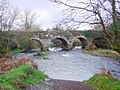
Macroom is built on the River Sullane, which flows into the River Lee. The town is in a valley at the bottom of the Boggeragh Mountains. It stretches for about 2 miles and has two main streets, Main Street and New Street. These are separated by the Ten Arch Bridge.
Like the rest of Ireland, Macroom has a mild, wet climate. It's influenced by the North Atlantic Current, which means mild winters and cool summers. It rains a lot throughout the year, about 1164 mm on average. Snow is rare, usually falling for only 2-3 days a year in January or February. The average temperature is 10.1 °C.
Macroom's Economy

The economy of Macroom is mostly based on farming. Local dairy farmers are part of the Dairygold co-operative. Their milk is processed and sent to the local Danone factory. This factory makes baby formula for sale all over the world.
Fun Things to See and Do

Macroom has several attractions for visitors. You can explore the town center, play at an 18-hole golf course, or walk around the Castle Grounds. You can also go fishing or golfing there.
The area around Macroom has many ancient stone monuments, early Christian holy wells, and churches. Mushera Mountain, a few kilometers north of town, has the old Saint John's Well.
The Castle Arch is a main feature of the old castle grounds. It lets walkers enter the parklands. This park is owned by the people of Macroom. It has lovely riverside walks among old oak and beech trees.
The Gearagh: A Submerged Forest

The Gearagh is a special nature reserve about 1.5 km south of Macroom. It's an inland delta with many small islands and river channels. This area has been wooded since the last Ice Age, about 8,000 BC. It used to have many old oak and ash trees.
In 1954, much of the Gearagh was changed when a hydro-electric power project flooded the area. Many trees were cut down, and old houses became submerged. Today, you can still see some of these submerged houses from certain spots. This project caused the loss of 60% of the oak woodland.

The Gearagh is very important because it has a rare and diverse range of wildlife. It's the only large alluvial woodland left in Western Europe. It's home to many rare plants, including marsh marigold and meadowsweet. It also has 62 types of moss and liverwort.
Today, you'll find willow and alder trees on the higher islands. The Gearagh is also a home for many birds and wildfowl, including mallards, wigeon, Greylag geese, herons, and coots. It also has Atlantic salmon and the rare freshwater pearl mussel. The area is protected by an international agreement called the Ramsar Convention.
Carrigaphooca Castle: A Historic Tower

Carrigaphooca Castle is a ruined five-story tower house. It sits on a steep rock overlooking the River Sullane, about 6 km west of Macroom. This area was once known as Gleann na n-Dearg, meaning 'Valley of the Reds'.
The tower was built as a defense by a MacCarthy clan member around 1336–1351. In 1601, Cormac Teige MacCarthy, the Lord of Blarney, hid in the tower. He had sided with the Irish during the Siege of Kinsale. He stayed there until Elizabeth I forgave him after he wrote her an apology letter. In 1602, the castle was attacked and taken by another MacCarthy family member.
Carrigaphooca is in an area with many ancient monuments. A stone circle is just two fields to the east. The castle is on private land and is not open to the public, but the state maintains it.
Mountain Dew Festival: Music and Fun
From 1976 to 1982, Macroom hosted the yearly Macroom Mountain Dew Festival. Young local business people organized it. These festivals attracted up to 20,000 people each year! Famous bands like Rory Gallagher, Thin Lizzy, and Van Morrison played there.
It was the first festival of its kind in Ireland. It was meant to bring excitement and new life to the town. One of the organizers, Martin Fitzgerald, said the town needed "a bit of shake rattle and roll" to attract people.
Churches in Macroom
According to the 2011 census, most people in Macroom are Roman Catholic. The town's Catholic church, dedicated to St. Coleman, was built in 1841. It was updated in 1893.
Macroom also has a Church of Ireland building, built in 1823. This building is now old and unused, but the graveyard is still used. There are also remains of an old thatched chapel on Lackaduduv mountain, west of the town. It's known locally as "Carrignaspirroge Chapel."
Getting Around Macroom
Macroom is on the N22 road, about 38 km from Cork city and 48 km from Killarney. The closest airport is Cork Airport.
A railway line used to run between Macroom and Cork city from 1866 to 1953. By 1890, there were five trains each way on weekdays and two on Sundays. The trip took just over an hour. Macroom railway station opened on May 12, 1866. It closed for passengers in 1935 and for goods in 1947, finally closing completely in 1953.
Schools in Macroom
Macroom has two primary schools and three secondary schools.
- A De La Salle secondary school for boys.
- St. Mary's Secondary School (Sisters of Mercy) for girls.
- McEgan College, a mixed technical college located in the castle grounds.
The Convent of Mercy school is part of the Sisters of Mercy's complex, which is next to St. Colman's Church. This complex also includes a convent, a primary school, a graveyard, and a grotto.
Coláiste De La Salle opened in 1933. It was first in the Macroom Town Hall until its own building was finished three years later. A new building was built in 2008 for St Colman's Boys National School.
Famous People from Macroom
- Rena Buckley (born 1986/1987), a very successful Gaelic Athletic Association (GAA) player.
- Eibhlín Dubh Ní Chonaill (around 1743–1800), a noblewoman and poet.
- Donal Creed (1924–2017), a politician who was a Member of the European Parliament (MEP) and a Minister.
- Michael Creed (born 1963), a former Minister for Agriculture, Food and the Marine.
- Dermot Desmond (born 1950), a very wealthy businessman.
- Ann Kelleher, a vice-president at Intel.
- Art Ó Laoghaire (1746–1773), a noble and a captain.
- Peadar Ua Laoghaire (1839–1920), a Catholic priest and writer during the Gaelic revival.
- Michael O'Leary (died 1961), received the Victoria Cross for bravery in the First World War.
- Rita Lynch (1914–2009), a singer.
- Jimmy MacCarthy (born 1953), a singer and songwriter.
- Morgan McSweeney (born 1977), a communications director for the British government.
- John A. Murphy (1927–2022), a historian and former senator.
- T. J. Murphy (1893–1949), a Labour Party politician.
- T. C. Murray (1873–1959), a playwright whose works were performed on Broadway.
- Timothy Quill (1901–1960), a Labour Party politician.
- Bambie Thug (born 1993), a singer-songwriter who represented Ireland in the Eurovision Song Contest 2024.
Images for kids
-
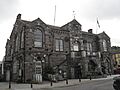
Macroom Town Hall was built for £1,000 in 1900.
-
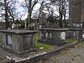
Graveyard in the Church of Ireland churchyard.
-
Street houses on Bridge Street, with the castle ruins in the background.
-
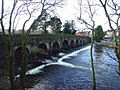
Bridge over the Sullane.
-
Morris's Bridge, Dromduff.
-
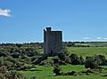
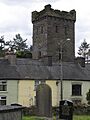
The MacCarthy tower house, Carrigaphooca Castle, built around 1436.


See also
 In Spanish: Macroom para niños
